

View Information About HSR Ratings
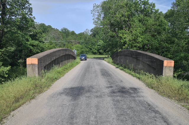
This is one of several rare examples of curved chord through girders found only in Parke County, and no other county in Indiana. The bridge may date to ca. 1920.
Information and Findings From DHPA Historic Bridge SurveyBridge History and Significance The tops of the girders of this structure are arched about 2-feet at center. The girders are about 5-feet high at the ends, about 2-feet wide, and are panelled. The superstructure carries a slab deck and the whole rests upon concrete abutments and flared wingwalls. Parke County has the only arched girders extant in Indiana. The arch was probably introduced to provide unusual girder depth at center for this extraordinarily long span and to eliminate redundant material at the ends. In addition, only a minority of concrete through girders use a slab rather than floor-beams to support the roadway. The girders are also decorated. References Beam, Longest & Neff, Inc., Bridge Inventory Rating and Safety Inspection: Parke County (Indianapolis, 1974, 1979). Congdon Engineering Associates, Bridge Inventory Rating and Safety Inspection: Parke County (Indianapolis, 1986). Farrar, Garvey & Associates, Parke County Bridge Inspection: Phase II, 2002 (Indianapolis, 2002). James L. Cooper, Artistry and Ingenuity in Artificial Stone: Indiana's Concrete Bridges, 1900-1942 (Greencastle, Indiana, 1997), 245-247. Bridge Considered Historic By Survey: Yes |
![]()
![]()
![]()
Coordinates (Latitude, Longitude):
Search For Additional Bridge Listings:
Bridgehunter.com: View listed bridges within 0.5 miles (0.8 kilometers) of this bridge.
Bridgehunter.com: View listed bridges within 10 miles (16 kilometers) of this bridge.
Additional Maps:
Google Streetview (If Available)
GeoHack (Additional Links and Coordinates)
Apple Maps (Via DuckDuckGo Search)
Apple Maps (Apple devices only)
Android: Open Location In Your Map or GPS App
Flickr Gallery (Find Nearby Photos)
Wikimedia Commons (Find Nearby Photos)
Directions Via Sygic For Android
Directions Via Sygic For iOS and Android Dolphin Browser
USGS National Map (United States Only)
Historical USGS Topo Maps (United States Only)
Historic Aerials (United States Only)
CalTopo Maps (United States Only)

© Copyright 2003-2026, HistoricBridges.org. All Rights Reserved. Disclaimer: HistoricBridges.org is a volunteer group of private citizens. HistoricBridges.org is NOT a government agency, does not represent or work with any governmental agencies, nor is it in any way associated with any government agency or any non-profit organization. While we strive for accuracy in our factual content, HistoricBridges.org offers no guarantee of accuracy. Information is provided "as is" without warranty of any kind, either expressed or implied. Information could include technical inaccuracies or errors of omission. Opinions and commentary are the opinions of the respective HistoricBridges.org member who made them and do not necessarily represent the views of anyone else, including any outside photographers whose images may appear on the page in which the commentary appears. HistoricBridges.org does not bear any responsibility for any consequences resulting from the use of this or any other HistoricBridges.org information. Owners and users of bridges have the responsibility of correctly following all applicable laws, rules, and regulations, regardless of any HistoricBridges.org information.
![]()