

View Information About HSR Ratings
This two span through truss bridge continues to carry vehicular traffic in good condition.
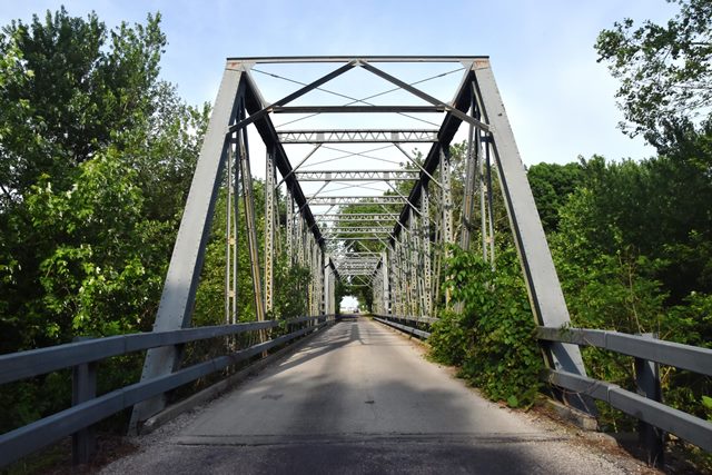
Information and Findings From DHPA Historic Bridge SurveyBridge History and Significance See Cooper's October 1993 report for a detailed discussion of the most-likely construction contractor and bridge designer and fabricator. It appears that the bridge was built as part of a road contract and that Caldwell and Drake did the design and fabrication of the New Hope Bridge superstructure. The National Register nomination relied on the Cooper report. Seated upon a concrete pier, abutments and wing-walls, the riveted Pratt 23.5-foot high trusses have intermediate verticals of two pairs of laced angles. The diagonals, counters, outer verticals, and lower-chord members were fabricated from two pairs of angles riveted together with battens. The diagonal sets in the two most central panels are countered. The I floor-beams are riveted to the verticals and lower chord at chord level. The bridge carries a concrete roadway between latticed hub-guards and with 15 feet of vertical clearance. Riveted Pratt through structures are not plentiful in Indiana, although Bartholomew County retains a few. Aside from the placement of the floor-beams, the design of the spans is rather conventional. Rehabilitated in 1999. References AECON, Inc., Bridge Reinspection Study & Report: Bartholomew County (Nashville, 1978, 1981). United Consulting Engineers, Bridge Inventory Report: Bartholomew County (Indianapolis, 2002, 2004). James L. Cooper, "County Commissioners among Engineers and Industrialists: Bartholomew County's Pugh Ford (#73) and New Hope (#133) Bridges" (October 1993). Anthony Schoettle, "The Bridges of Bartholomew County," The Republic, 11 Sept. 1994, B1. Bridge Considered Historic By Survey: Yes |
![]()
![]()
![]()
Coordinates (Latitude, Longitude):
Search For Additional Bridge Listings:
Bridgehunter.com: View listed bridges within 0.5 miles (0.8 kilometers) of this bridge.
Bridgehunter.com: View listed bridges within 10 miles (16 kilometers) of this bridge.
Additional Maps:
Google Streetview (If Available)
GeoHack (Additional Links and Coordinates)
Apple Maps (Via DuckDuckGo Search)
Apple Maps (Apple devices only)
Android: Open Location In Your Map or GPS App
Flickr Gallery (Find Nearby Photos)
Wikimedia Commons (Find Nearby Photos)
Directions Via Sygic For Android
Directions Via Sygic For iOS and Android Dolphin Browser
USGS National Map (United States Only)
Historical USGS Topo Maps (United States Only)
Historic Aerials (United States Only)
CalTopo Maps (United States Only)

© Copyright 2003-2026, HistoricBridges.org. All Rights Reserved. Disclaimer: HistoricBridges.org is a volunteer group of private citizens. HistoricBridges.org is NOT a government agency, does not represent or work with any governmental agencies, nor is it in any way associated with any government agency or any non-profit organization. While we strive for accuracy in our factual content, HistoricBridges.org offers no guarantee of accuracy. Information is provided "as is" without warranty of any kind, either expressed or implied. Information could include technical inaccuracies or errors of omission. Opinions and commentary are the opinions of the respective HistoricBridges.org member who made them and do not necessarily represent the views of anyone else, including any outside photographers whose images may appear on the page in which the commentary appears. HistoricBridges.org does not bear any responsibility for any consequences resulting from the use of this or any other HistoricBridges.org information. Owners and users of bridges have the responsibility of correctly following all applicable laws, rules, and regulations, regardless of any HistoricBridges.org information.
![]()