

View Information About HSR Ratings
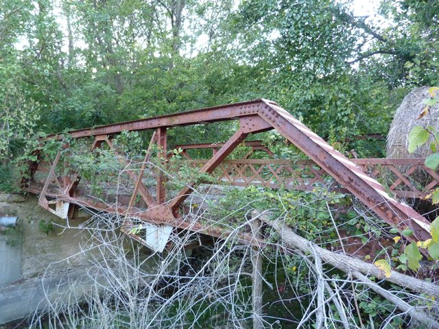
This bridge was reportedly bypassed in 1993. It remains standing abandoned next to its replacement. With a listed construction date of 1917, this bridge's riveted connections and Warren configuration are typical for the period in which the bridge was built. What is not typical is the decorative ball finials mounted on top of the ends of the railing. Decorations of this sort were used more frequently on pre-1900 truss bridges, usually through trusses, and usually mounted on top of the trusses. Such decorations are highly unusual on a 1917 bridge. It is not sure why this bridge had such decorations included. It may be a "trademark" of a particular bridge builder, but it is not known what company might have built this bridge.
Information and Findings From DHPA Historic Bridge SurveyDescription Concrete abutments and wingwalls inscribed with "1917" support the single-span Warren pony truss. The riveted structure extends 40' in three panels. Its all-interior verticals are manufactured from a pair of angles riveted tightly together with stay plates and reinforced with external sway bracing. The diagonals are also made of a pair of angles riveted tightly together with stay plates. The I floor-beams are attached to gussets and carry the asphalt-over-concrete deck with its 15'6" roadway. While the uniform size of the diagonals suggests an early stage in all-riveted Warren pony construction, the use of external sway braces represents a later design development. This bridge is of otherwise standard design and retains its original members, including latticed guardrails. References AECON, Inc., Bridge Inventory & Inspection Report: Dearborn County (Nashville, 1973); Bridge Reinspection Study & Report: Dearborn County (Nashville,1978). Howard J. Barth & Associates, Dearborn County: Bridge Reinspection Report (Greensburg, 1998). Indiana Historic Sites & Structures Inventory, Dearborn County: Interim Report (Indianapolis, 1983). Bridge Considered Historic By Survey: Yes |
![]()
![]()
![]()
Coordinates (Latitude, Longitude):
Search For Additional Bridge Listings:
Bridgehunter.com: View listed bridges within 0.5 miles (0.8 kilometers) of this bridge.
Bridgehunter.com: View listed bridges within 10 miles (16 kilometers) of this bridge.
Additional Maps:
Google Streetview (If Available)
GeoHack (Additional Links and Coordinates)
Apple Maps (Via DuckDuckGo Search)
Apple Maps (Apple devices only)
Android: Open Location In Your Map or GPS App
Flickr Gallery (Find Nearby Photos)
Wikimedia Commons (Find Nearby Photos)
Directions Via Sygic For Android
Directions Via Sygic For iOS and Android Dolphin Browser
USGS National Map (United States Only)
Historical USGS Topo Maps (United States Only)
Historic Aerials (United States Only)
CalTopo Maps (United States Only)

© Copyright 2003-2026, HistoricBridges.org. All Rights Reserved. Disclaimer: HistoricBridges.org is a volunteer group of private citizens. HistoricBridges.org is NOT a government agency, does not represent or work with any governmental agencies, nor is it in any way associated with any government agency or any non-profit organization. While we strive for accuracy in our factual content, HistoricBridges.org offers no guarantee of accuracy. Information is provided "as is" without warranty of any kind, either expressed or implied. Information could include technical inaccuracies or errors of omission. Opinions and commentary are the opinions of the respective HistoricBridges.org member who made them and do not necessarily represent the views of anyone else, including any outside photographers whose images may appear on the page in which the commentary appears. HistoricBridges.org does not bear any responsibility for any consequences resulting from the use of this or any other HistoricBridges.org information. Owners and users of bridges have the responsibility of correctly following all applicable laws, rules, and regulations, regardless of any HistoricBridges.org information.
![]()