

View Information About HSR Ratings
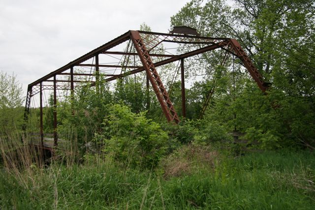
This bridge was built by the Wrought Iron Bridge Company. The prolific bridge builder had several different standardized truss designs it built over the years of its existence. What is most unusual about this example is that it deviates from the standardized design by introducing lattice on top of the top chord and end post in place of the usual cover plate. It is unclear why the Wrought Iron Bridge Company, which while noted for its diversity of standard truss designs, made an unusual deviation from the specifics of one of those standard designs. Otherwise, the bridge retains typical details including the plaque, vertical members and struts with no v-lacing, and the unusual lightweight rod which runs horizontally through the middle of the truss web.
This bridge has been bypassed and left standing next to a replacement bridge.
Normally, HistoricBridges.org would offer nothing other than high praise for Parke County for leaving this historic bridge standing next to its replacement, even in an abandoned condition. Many states refuse to do this even though it is essentially a zero cost preservation option, that is easy to do. However, given the fact that over 30 wooden covered bridges have been preserved in this county, either for continued vehicular use or bypassed and preserved for pedestrian use, it is nothing short of ridiculous that one of the only three metal truss bridges in the county has not been fully restored and maintained for easy pedestrian access in the way so many covered bridges have. Where all the wooden covered bridges have fresh paint, and those which are bypassed have the grass around them cut and maintained, and all have interpretive signage, this iron bridge sits rusted, overgrown and surrounded by weeds, and has no interpretive signage. Nor is the bridge listed on any of the literature and pamphlets that advertise Parke County covered bridges. How many people have come to see the Mansfield Covered Bridge, and never known that less than a mile away they could have also visited this beautiful wrought iron bridge? How hard would it be to simply cut the grass around the bridge? Is there such a bias toward covered bridges and against metal truss bridges that they will cut the grass around a covered bridge, but leave the metal truss bridge surrounded by weeds?! This historic iron truss bridge, far more rare than the covered bridges in the county, and even older than a number of the covered bridges, is of equal or greater historic and technological significance than many of the covered bridges. It deserves at the very minimum the same level of attention and care that Parke County's covered bridges have received.
Information and Findings From DHPA Historic Bridge SurveyStatement of Significance Built by a prolific Ohio firm, this bridge retains its original members, including decoratively latticed portals, portal bracing, and guardrails. As stated above, the design of the endposts is noteworthy. Architectural Description The Wrought Iron Bridge Company of Canton, Ohio, fabricated this single-span, pin-connected Pratt through truss which is seated upon cut stone abutments and wingwalls. Intermediate verticals of reinforced I beams divide the 104' span into most of its seven panels. Eyebars provide the diagonals: pairs stretch toward center span from the top panel point to the bottom of the 2nd, 3rd, 5th, and 6th panels; a cylindrical eyebar with a turnbuckle counters the others in these panels and crosses the 4th or center panel. An adjustable cylindrical eyebar runs through the three most central verticals horizontal to and about midway between the chords, possibly to enhance the truss' stability. U-bolted to the lower pins, rectangular girder floor beams carry the timber deck with its 16'1" roadway and 17' of vertical clearance. The endposts of latticed channels are a quite unusual feature of this bridge. Bibliography Beam, Longest & Neff, Inc., Parke County Bridge Inventory Rating and Safety Inspection (Indianapolis, 1974, 1979). Bridge Considered Historic By Survey: Yes |
![]()
![]()
![]()
Coordinates (Latitude, Longitude):
Search For Additional Bridge Listings:
Bridgehunter.com: View listed bridges within 0.5 miles (0.8 kilometers) of this bridge.
Bridgehunter.com: View listed bridges within 10 miles (16 kilometers) of this bridge.
Additional Maps:
Google Streetview (If Available)
GeoHack (Additional Links and Coordinates)
Apple Maps (Via DuckDuckGo Search)
Apple Maps (Apple devices only)
Android: Open Location In Your Map or GPS App
Flickr Gallery (Find Nearby Photos)
Wikimedia Commons (Find Nearby Photos)
Directions Via Sygic For Android
Directions Via Sygic For iOS and Android Dolphin Browser
USGS National Map (United States Only)
Historical USGS Topo Maps (United States Only)
Historic Aerials (United States Only)
CalTopo Maps (United States Only)

© Copyright 2003-2026, HistoricBridges.org. All Rights Reserved. Disclaimer: HistoricBridges.org is a volunteer group of private citizens. HistoricBridges.org is NOT a government agency, does not represent or work with any governmental agencies, nor is it in any way associated with any government agency or any non-profit organization. While we strive for accuracy in our factual content, HistoricBridges.org offers no guarantee of accuracy. Information is provided "as is" without warranty of any kind, either expressed or implied. Information could include technical inaccuracies or errors of omission. Opinions and commentary are the opinions of the respective HistoricBridges.org member who made them and do not necessarily represent the views of anyone else, including any outside photographers whose images may appear on the page in which the commentary appears. HistoricBridges.org does not bear any responsibility for any consequences resulting from the use of this or any other HistoricBridges.org information. Owners and users of bridges have the responsibility of correctly following all applicable laws, rules, and regulations, regardless of any HistoricBridges.org information.
![]()