

View Information About HSR Ratings
This is one of an impressive number of concrete arch bridges documented in Fort Wayne.

Above: Historical photo showing original railing.

Above: Photo From 1988 by James Cooper showing bridge with first replacement railing.

Above: Photo From 1988 by James Cooper showing bridge with first replacement railing.
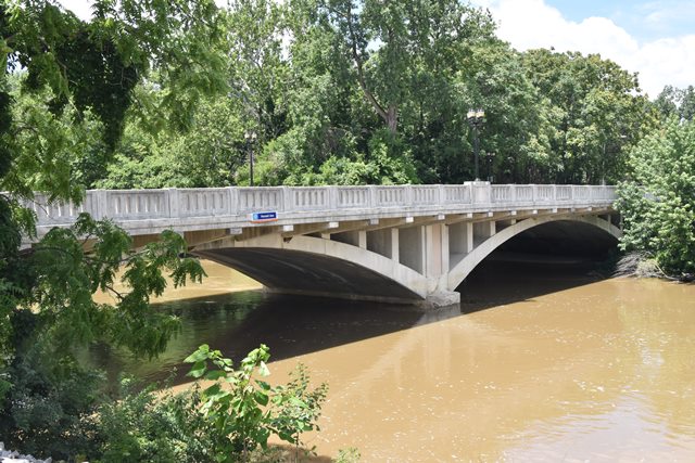
Information and Findings From DHPA Historic Bridge SurveyBridge History and Significance Where the distance between the roadway and the stream and the volume carried by the watercourse are both considerable, the weight of the fill and the required side-to-side width of the structure reduces the economic advantages of filled-spandrel reinforced concrete arches. The open-spandrel arch, which requires a good bit of formwork and is therefore an expensive alternative, may then become the form of choice. In large open-spandrel structures, the arch ring is often composed of two or more longitudinal ribs. A series of columns support the deck and transfer the loads to the ribs or ring. Beams and slabs, in turn, carry the floor. Because of their expense, only a couple dozen of these structures have been built in Indiana. The Allen county commissioners appointed A. W. Grosvenor as "Engineer of Construction" in March 1926 and agreed to pay him $100 a day (up to $2,600) for the drafting of plans and specifications for the Parnell Avenue Bridge. Grosvenor filed his plans on 14 June, and Daniel B. Luten added a set of his own at the end of the month. Henry C. Paul and others petitioned the commissioners to submit the bridge plans to the state highway commission for evaluation. At the 9 July letting, the National Concrete Company brought in the lowest bids on two different Luten-designs. The board, however, let a contract to I. E. Smith of Richmond on Grosvenor's plans for $82,900, about $5,000 more than the highest bid on a Luten-design. Each span carries four segmental ribs with two-tier reinforcing plus stirrups and 13-feet and 6-inches of rise. Spandrel columns support the deck which the Moellering Construction Company rebuilt in 1970 under the direction of Karl F. Johnson, Allen County Engineer. The concrete slab deck is cantilevered about 5 feet beyond each outer rib to carry the sidewalks. Hoosier county officials built about a dozen open-spandrel concrete arches before 1930. The deck of this one was replaced in 1970 with a wider one cantilevered beyond the outer ribs. In 1993, this deck was widened still more, this time carried by beams supported on the spandrel columns. The metal rails installed in 1970 were replaced with concrete parapets with open-arch panels more in keeping with the structure's original decor. References Butler, Fairman & Seufert, Inc., Bridge Inspection/Reinspection Report: Allen County (Indianapolis, 1973, 1977, 1981). SIECO, Inc., Bridge Reinspection Report: Allen County (Columbus, 1993, 1995). Farrar, Garvey & Associates, Allen County: Bridge Inspection (Indianapolis, 2002, 2004). Clark Dietz, Inc., Allen County: Bridge Inspection Project (Indianapolis, 2008). bridge nameplate. Allen County, "Commissioners Record," 17: 112, 119, 132-133, 163, 205, 220, 228-229, 232, 242, 255; "Old Bridges" (Surveyor's Office), 13E: 22. "Ft. Wayne," "Contracts Awarded -- Ind., Ft. Wayne," Supplement, Engineering News-Record: 1 July 1926: 67; 22 July 1926: 59. Bridge Considered Historic By Survey: Yes |
![]()
![]()
![]()
Coordinates (Latitude, Longitude):
Search For Additional Bridge Listings:
Bridgehunter.com: View listed bridges within 0.5 miles (0.8 kilometers) of this bridge.
Bridgehunter.com: View listed bridges within 10 miles (16 kilometers) of this bridge.
Additional Maps:
Google Streetview (If Available)
GeoHack (Additional Links and Coordinates)
Apple Maps (Via DuckDuckGo Search)
Apple Maps (Apple devices only)
Android: Open Location In Your Map or GPS App
Flickr Gallery (Find Nearby Photos)
Wikimedia Commons (Find Nearby Photos)
Directions Via Sygic For Android
Directions Via Sygic For iOS and Android Dolphin Browser
USGS National Map (United States Only)
Historical USGS Topo Maps (United States Only)
Historic Aerials (United States Only)
CalTopo Maps (United States Only)

© Copyright 2003-2026, HistoricBridges.org. All Rights Reserved. Disclaimer: HistoricBridges.org is a volunteer group of private citizens. HistoricBridges.org is NOT a government agency, does not represent or work with any governmental agencies, nor is it in any way associated with any government agency or any non-profit organization. While we strive for accuracy in our factual content, HistoricBridges.org offers no guarantee of accuracy. Information is provided "as is" without warranty of any kind, either expressed or implied. Information could include technical inaccuracies or errors of omission. Opinions and commentary are the opinions of the respective HistoricBridges.org member who made them and do not necessarily represent the views of anyone else, including any outside photographers whose images may appear on the page in which the commentary appears. HistoricBridges.org does not bear any responsibility for any consequences resulting from the use of this or any other HistoricBridges.org information. Owners and users of bridges have the responsibility of correctly following all applicable laws, rules, and regulations, regardless of any HistoricBridges.org information.
![]()