

View Information About HSR Ratings
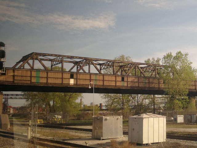
This bridge consists of a through truss main span. Immediately north of this span is a pony truss approach span. Additionally, each end of the bridge has curved approach consisting of a number of riveted through plate girder spans. All these approach spans, which provide the ramp leading up to this overpass's height over the railroad tracks, produce a bridge of reasonable length. There once were several truss bridges that carried a highway over railroad tracks in Lake County, Indiana. Today, this is the last know surviving example. This privately owned bridge crossing privately owned railroad tracks is located deep within a high security area consisting of steel mills. HistoricBridges.org is unaware of any way to properly photo-document this historic bridge. The only way the public can normally view this bridge is to view it from the dirty windows of the Amtrak trains that pass under the bridge. Unfortunately, a few low-quality photos taken under these undesirable circumstances are all that HistoricBridges.org currently has available. If Amtrak would actually wash the windows on its cars once in a while, someone could probably get some decent overview photos of the bridge.
If anyone has better or additional photos of this bridge and is willing to share them, please contact us. We would also be interested if anyone knows how to get permission to visit and photograph this bridge.
![]()
![]()
![]()
Coordinates (Latitude, Longitude):
Search For Additional Bridge Listings:
Bridgehunter.com: View listed bridges within 0.5 miles (0.8 kilometers) of this bridge.
Bridgehunter.com: View listed bridges within 10 miles (16 kilometers) of this bridge.
Additional Maps:
Google Streetview (If Available)
GeoHack (Additional Links and Coordinates)
Apple Maps (Via DuckDuckGo Search)
Apple Maps (Apple devices only)
Android: Open Location In Your Map or GPS App
Flickr Gallery (Find Nearby Photos)
Wikimedia Commons (Find Nearby Photos)
Directions Via Sygic For Android
Directions Via Sygic For iOS and Android Dolphin Browser
USGS National Map (United States Only)
Historical USGS Topo Maps (United States Only)
Historic Aerials (United States Only)
CalTopo Maps (United States Only)

© Copyright 2003-2026, HistoricBridges.org. All Rights Reserved. Disclaimer: HistoricBridges.org is a volunteer group of private citizens. HistoricBridges.org is NOT a government agency, does not represent or work with any governmental agencies, nor is it in any way associated with any government agency or any non-profit organization. While we strive for accuracy in our factual content, HistoricBridges.org offers no guarantee of accuracy. Information is provided "as is" without warranty of any kind, either expressed or implied. Information could include technical inaccuracies or errors of omission. Opinions and commentary are the opinions of the respective HistoricBridges.org member who made them and do not necessarily represent the views of anyone else, including any outside photographers whose images may appear on the page in which the commentary appears. HistoricBridges.org does not bear any responsibility for any consequences resulting from the use of this or any other HistoricBridges.org information. Owners and users of bridges have the responsibility of correctly following all applicable laws, rules, and regulations, regardless of any HistoricBridges.org information.
![]()