

View Information About HSR Ratings
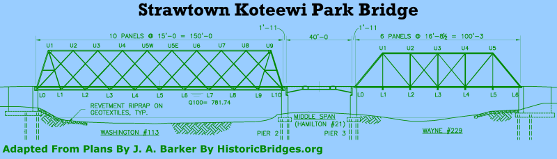
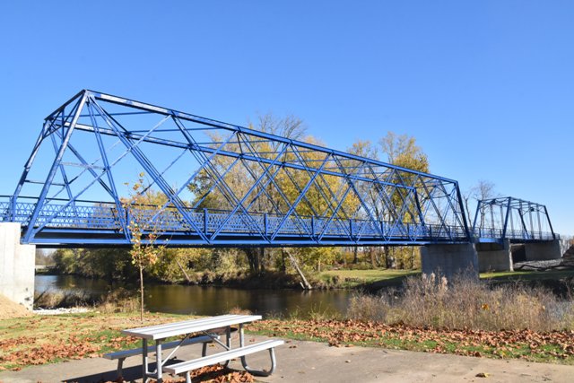
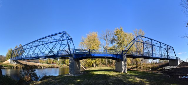
This bridge represents one of the most unique and best historic bridge restoration projects in the entire country. To create this beautiful, signature crossing for non-motorized traffic, two different historic truss bridges from two different counties were relocated, restored, and installed here to create single multi-span bridge crossing. Two two historic bridges were a pin-connected Pratt through truss span from Wayne County, Indiana (Bridge 229) and the rare Triple Intersection Warren (Lattice) through truss span from Washington County, Indiana (Bridge 113). To provide the needed length, a bit more bridge was needed... where most projects would simple add modern, mundane approach spans, this project instead did something truly unique which was to create a replica of a rare type of bridge that was demolished years ago in Hamilton County. Original 19th Century plans for Indiana Bridge Company's unusual "plate leg" girder bridge (Hamilton Bridge 21) were used to fabricate a replica of the bridge, which serves as a short middle span, creating in total a three span bridge consisting of two original historic bridges plus a replica of a rare and demolished bridge.
Visit the Nickelsen Creek Bridge page to see photos of the only known surviving original Indiana Bridge Company plate girders. That page also has a company advertisement and drawing of the girder. Bridgehunter has pages of the Wayne County Bridge and the Washington County Bridge in their previous locations.
The impressive, high-quality restoration of the two through truss spans (both of which had significant deterioration) were designed by James Barker (now with VS Engineering). Restoration was for the most part in-kind, with all rivets replaced in the shop being replaced in-kind with rivets. The only exception to in-kind restoration practice on this project was that bolts were used instead of rivets were for field connections of the Lattice truss span. It is not entirely clear why field riveting was not done here. Historical style (but meeting modern code) riveted lattice railings were installed on the bridge. It is also worth noting that these bridges, with no major alterations or enhancements to the original design, were designed to meet the (rather ridiculously high) AASHTO live load guideline of 85 pounds per square foot (PSF), which is a loading designed to accommodate a situation where the bridge would be packed shoulder-to-shoulder with people, something this bridge almost certainly will never see. It is worth noting this 85PSF rating however, because this heavy load guideline often leads engineers to believe historic bridges cannot be restored for pedestrian use under these loadings. This bridge shows three different historic truss bridge types that meet the 85PSF loading with no noteworthy alterations needed.
It is also worth noting that both of the historic through truss spans were placed into storage for several years before this project came into reality. While Indiana, as part of its bridge marketing program, often places its historic bridges in storage for at least 10 years of availability, other states like Pennsylvania continuously refuse to do so, and instead do short marketing periods and require new owners to be "shovel ready" at the exact same time the bridge is being removed from its previous location, resulting in a nearly complete lack of success in bridge marketing program. The Strawtown Bridge proves that a storage period for bridges being marketed not only works for marketing single spans, it also is the only way a unique project like this one (using multiple spans that were removed from service at different times) could become reality.
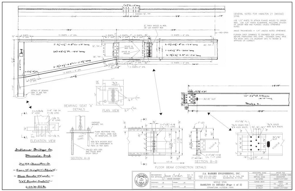
Above: One of the sheets from the contract plans for the Strawtown Bridge project showing the Hamilton 21 cantilever plate girder span. This is one of the most unique, creative, and awesome productions by a 21st Century bridge engineer: Engineer James Barker literally scanned the original 19th Century drawings for the Indiana Bridge Company's plate girder design, pasted them into the CAD program, and added some of his own notations and detail drawings for better clarity to 21st Century contractors, certified it to meet 21st Century AASHTO guidelines, and put his stamp on the end product. It is easy to see which text on the sheet dates to the 19th Century due to the handwritten script. As such, this span is a true replica of a historic bridge design, not the typical fake-looking affairs that usually results from an engineer claiming that a new bridge will be a "replica."
Information and Findings From DHPA Historic Bridge SurveyWashington County Bridge 113 Discussion Carried: County Route #78 Over: Blue River. Built: 1897 by Chicago Bridge and Iron Company of Chicago, Illinois. The 150' triple-intersection Warren of ten all-riveted quite light panels rests upon masonry abutments and wingwalls. The bridge's designers made the endposts nearly vertical and eliminated all interior verticals. The diagonals stretching towards the abutments from the top panel points are made from a pair of laced angles; those inserted toward midspan are simple angles; and all members are riveted to each other where they intersect. The channels of the top chord are laced rather than riveted to a cover plate. Riveted to the truss at and above the lower chord, I floor-beams support the timber deck with its 14'8" roadway and 15'6" of vertical clearance. The significance of this structure is not limited to the fact that it is the single extant triple-intersection Warren through in Indiana. Its design is also unusual. It is both long and light: some standard members are eliminated, and all are simply and minimally constructed. The unadorned structure retains its original members. References Warren T. Hobson and Associates, Bridge Inspection Report: Washington County (Indianapolis, 1974, 1979). Hamilton County Bridge 21 Discussion Carried: Joliet Rd. Over: Finley Creek. 40 foot span, built 1891, demolished and replaced 1991. The Indiana Bridge Company of Muncie designed and fabricated this slightly skewed (c.3'), riveted "plate leg" girder. Seated upon concrete abutments and wingwalls, the single-span girder extends 40' with three plates (one for each panel) per girder. The flange ends are square, and neither top nor bottom has a cover plate. The outer panel plate tapers from 3' at the abutment to 2' where it joins the rectangular center panel. Riveted to the plates, two I floor-beams supported runs of steel stringers and the asphalt-over-metal-pan roadway between latticed rails. This structure was among the oldest plate girders in Indiana and illustrates the design ingenuity of one of the state's most prolific bridge builders. The flaring of the outer girder plates towards the abutment braces the whole. References Beam, Longest and Neff, Hamilton County Bridge Inventory Rating and Safety Inspection (Indianapolis, 1974, 1977, 1981). Indiana Bridge Company, contract #329; drawing #587 (Drawings Archive, School of Architecture, Ball State University). Wayne County Bridge 229 Discussion Carried: Charles Rd. Over: Martindale Creek. Built: 1904. The New Castle Bridge Company of Indianapolis, Indiana, fabricated this single-span, pin-connected Pratt through truss which is seated upon concrete abutments and wingwalls. Intermediate verticals of a single size of laced channels subdivide the 102' span into most of its six panels. Eyebars provide the diagonals: pairs stretch toward center span from the top panel point to the bottom of all except the endpost panels; cylindrical eyebars with turnbuckles counter the others in the two most central panels. U-bolted to the lower pins, I floor-beams carry the timber deck with its 13'7" roadway and 17'6" of vertical clearance. Built by the predecessor of the prolific Central States Bridge Company, this bridge retains its original members. The structure is unadorned except for latticed guardrails. References Butler, Fairman and Seufert, Inc., Bridge Inspection/Reinspection Report: Wayne County (Indianapolis, 1973, 1979). bridge nameplate. Indiana Historic Sites and Structures Inventory, Wayne County: Interim Report (Indianapolis, 1981), 29-30. Bridge Considered Historic By Survey: Yes |
![]()
![]()
![]()
Coordinates (Latitude, Longitude):
Search For Additional Bridge Listings:
Bridgehunter.com: View listed bridges within 0.5 miles (0.8 kilometers) of this bridge.
Bridgehunter.com: View listed bridges within 10 miles (16 kilometers) of this bridge.
Additional Maps:
Google Streetview (If Available)
GeoHack (Additional Links and Coordinates)
Apple Maps (Via DuckDuckGo Search)
Apple Maps (Apple devices only)
Android: Open Location In Your Map or GPS App
Flickr Gallery (Find Nearby Photos)
Wikimedia Commons (Find Nearby Photos)
Directions Via Sygic For Android
Directions Via Sygic For iOS and Android Dolphin Browser
USGS National Map (United States Only)
Historical USGS Topo Maps (United States Only)
Historic Aerials (United States Only)
CalTopo Maps (United States Only)

© Copyright 2003-2026, HistoricBridges.org. All Rights Reserved. Disclaimer: HistoricBridges.org is a volunteer group of private citizens. HistoricBridges.org is NOT a government agency, does not represent or work with any governmental agencies, nor is it in any way associated with any government agency or any non-profit organization. While we strive for accuracy in our factual content, HistoricBridges.org offers no guarantee of accuracy. Information is provided "as is" without warranty of any kind, either expressed or implied. Information could include technical inaccuracies or errors of omission. Opinions and commentary are the opinions of the respective HistoricBridges.org member who made them and do not necessarily represent the views of anyone else, including any outside photographers whose images may appear on the page in which the commentary appears. HistoricBridges.org does not bear any responsibility for any consequences resulting from the use of this or any other HistoricBridges.org information. Owners and users of bridges have the responsibility of correctly following all applicable laws, rules, and regulations, regardless of any HistoricBridges.org information.
![]()