

View Information About HSR Ratings
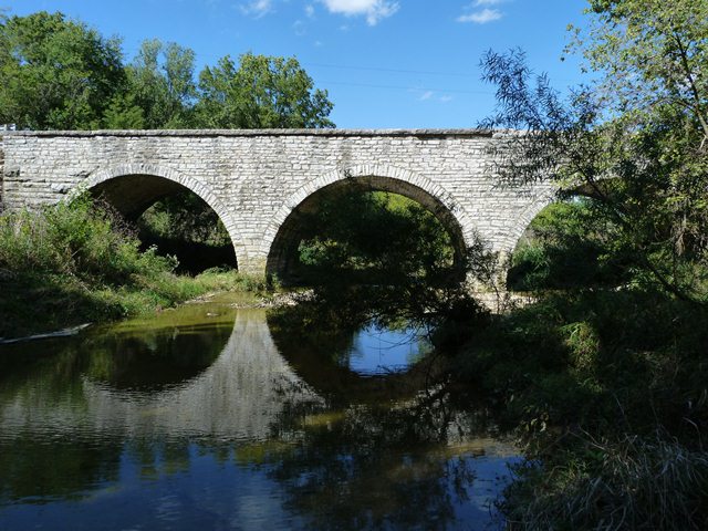
This bridge is one of a substantial number of stone arch bridges in this region. This particular example stands out for its multi-span design with fairly tall arches and noteworthy total length given other surviving examples in the area. The bridge is also noted for its lack of alteration. It is significant as a pre-1900 example, since a number of the stone arch bridges in the area date to after 1900.
Information and Findings From DHPA Historic Bridge SurveyStatement of Significance This bridge follows the conventions used with most of the stone arches built in the state's south-central counties anbd represents one of the nearly two dozen structures of its kind in Decatur County. The structure is unusually long, the spans particularly wide, and the whole remarkably close to its original condition. Architectural Description Local craftsmen built most of Indiana's stone arches from regional materials just before or in the first two decades of the 20th Century. Following a few simple rules of thumb that had evolved since Roman days,
stonemasons erected full-centered or semicircular arches in which the line of pressure passes through the center of each stone in the arch ring until carried vertically into the substructure. Most of the state's stone arches span
streams in south-central counties. With more than two dozen extant, Decatur County built the largest number. By World War I, the growing popularity of concrete, which engineers could readily adjust to the special needs of each
specific bridge site, quietly ended most stone arch construction in the region. Other Information On learning in December 1888 that the Ripley county commissioners were willing to participate in building of a bridge across the Muscatatuck on the Napoleon-Millhousen Road at the county line, the Decatur board begged off until the remodeling of the court house was complete. The Decatur commissioners would stick to their declared no-new-bridges for the duration policy. In mid-May 1892, the Ripley board again expressed its interest in a bridge on the county line, and this time the Decatur board agreed and appointed Samuel L. Anderson to draft plans and specifications. The boards held a joint meeting in Millhousen towards the end of the month and accepted Anderson's proposed specifications for a metal-truss structure. The letting was set for mid-July in Versailles, and the contract was to be awarded to "the lowest and best bidder." After considering 19 proposals, the joint boards accepted the bid of James W. Craig for "a triple arch bridge." Samuel Anderson was appointed superintendent of construction. In mid-October, the joint boards inspected the completed new bridge and accepted it at the contracted price of $2,537.88. In December 1894, the Decatur board took the lead in securing bids on "drywalls to support the fill of the approaches" and contracted with the Layton Brothers & Co. [George Layton] for the work. At the end of 1895, the Decatur commissioners again contracted with Layton Brothers & Co., this time for the erection of a stone wall to be built against the south side of the west approach. The agreed-upon price for the masonry was $1.50 per cubic yard. Bridge Considered Historic By Survey: Yes |
![]()
![]()
![]()
Coordinates (Latitude, Longitude):
Search For Additional Bridge Listings:
Bridgehunter.com: View listed bridges within 0.5 miles (0.8 kilometers) of this bridge.
Bridgehunter.com: View listed bridges within 10 miles (16 kilometers) of this bridge.
Additional Maps:
Google Streetview (If Available)
GeoHack (Additional Links and Coordinates)
Apple Maps (Via DuckDuckGo Search)
Apple Maps (Apple devices only)
Android: Open Location In Your Map or GPS App
Flickr Gallery (Find Nearby Photos)
Wikimedia Commons (Find Nearby Photos)
Directions Via Sygic For Android
Directions Via Sygic For iOS and Android Dolphin Browser
USGS National Map (United States Only)
Historical USGS Topo Maps (United States Only)
Historic Aerials (United States Only)
CalTopo Maps (United States Only)

© Copyright 2003-2026, HistoricBridges.org. All Rights Reserved. Disclaimer: HistoricBridges.org is a volunteer group of private citizens. HistoricBridges.org is NOT a government agency, does not represent or work with any governmental agencies, nor is it in any way associated with any government agency or any non-profit organization. While we strive for accuracy in our factual content, HistoricBridges.org offers no guarantee of accuracy. Information is provided "as is" without warranty of any kind, either expressed or implied. Information could include technical inaccuracies or errors of omission. Opinions and commentary are the opinions of the respective HistoricBridges.org member who made them and do not necessarily represent the views of anyone else, including any outside photographers whose images may appear on the page in which the commentary appears. HistoricBridges.org does not bear any responsibility for any consequences resulting from the use of this or any other HistoricBridges.org information. Owners and users of bridges have the responsibility of correctly following all applicable laws, rules, and regulations, regardless of any HistoricBridges.org information.
![]()