We Recommend:
Bach Steel - Experts at historic truss bridge restoration.
BridgeHunter.com Phase 1 is released to the public! - Visit Now
Lincoln Memorial Bridge
George Rogers Clark Bridge

Primary Photographer(s): Nathan Holth and Rick McOmber
Bridge Documented: May 9, 2010
Vincennes: Lawrence County, Illinois and Knox County, Indiana: United States
1931 By Builder/Contractor: Ferguson Construction of Rockford, Illinois and Engineer/Design: Bennett, Parsons, and Frost of Chicago, Illinois
1992
180.0 Feet (54.9 Meters)
1,020.0 Feet (310.9 Meters)
22 Feet (6.71 Meters)
7 Main Span(s)
32670

View Information About HSR Ratings
Bridge Documentation
View Archived National Bridge Inventory Report - Has Additional Details and Evaluation
View Historical Articles About This Bridge
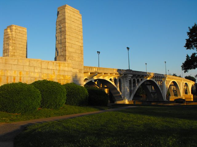
The Lincoln Memorial Bridge is a very special bridge because it so beautifully unites engineering and architecture making it one of the most beautiful concrete arch bridges encountered on today's roads. The arches themselves are beautifully designed with the curves of the arch spans complimented by the decorative arches that run under the deck line. The design of the railings and cantilevered sidewalks also shows an attention to detail, with the stepped design under the deck at the pier points, where the balustrade railings give way to a paneled design as well. Two massive decorative pylons at the Indiana corners of the bridge depict Native Americans and inscribed on these pylons is "Raovl Josset SC" which refers to Raoul Josset, Sculptor, a French artist. Thanks to a good rehabilitation and what appears to be continuing maintenance, the bridge continues to be in good condition.
The bridge is located next to the large and eye-catching George Rogers Clark Memorial which is the centerpiece for the National Historic Park which is adjacent to the bridge. The bridge itself is in a way part of the memorial, thanks to the decorative pylons. The bridge also could be considered a symbol of the other aspect of American heritage being remembered at this historic crossing, specifically a crossing where Abraham Lincoln crossed on a ferry to enter Illinois for the first time in his life. A small plaque on the Indiana side, and a larger monument on the Illinois side commemorates this event.
The Chicago firm Bennett, Parsons, and Frost was involved with the design of this bridge, likely as architects. Reportedly, the Indiana Highway Commission did the actual structural engineering.
Information and Findings From DHPA Historic Bridge SurveyStatement of Significance The IDH built very few open-spandrel arches in the
1930s, and none is as decorated as this bridge. The structure is the
longest of its kind in Indiana and has an unusually wide center span.
The bridge retains its architectural integrity. Architectural Description The Main Street, Vincennes, crossing of the Wabash
dates at least to 1805 when Colonel Francis Vigo received the first
ferry license on the river. In 1868 a timber-truss structure replaced
the ferry. A tornado damaged two spans adjacent to Vincennes in 1869,
leading in 1875 to their replacement with wrought and cast iron
bowstrings of Massillon Iron Bridge Company design and fabrication for
$10,000. In 1926 two Parker through-truss spans replaced the timber
trusses on the Illinois side, and in 1929 a pair of Warren pony trusses
was substituted for the center swing span. Vincennes officials began to
talk about the need for a new bridge as early as 1918 but regarded the
estimated cost of $200,000 as beyond their means. In 1923 the two state
highway departments first announced plans for replacement spans. Then,
by 1925, they decided to build a completely new 1,600 structure at a
cost of $2,000,000. The Indiana legislature appropriated funds for a
memorial to George Rogers Clark on the site of Fort Sackville in 1927,
and the sponsors of the memorial urged that the new bridge harmonize
with the memorial. Bibliography Engineering News-Record, 7 Feb, 7 March 1918, v80, p45, 451: Construction News, 13 Sept 1923, v91, p146; Construction News, 4 June 1925, v94, p320; 21 Jan 1926, v96, p122; 6 Jan 1927, v98, p36; 20 Nov 1930, v105, p811-12; 30 June 1932, v108, p930 Bridge Considered Historic By Survey: Yes |
![]()
Photo Galleries and Videos: Lincoln Memorial Bridge
Bridge Photo-Documentation
Original / Full Size PhotosA collection of overview and detail photos. This gallery offers photos in the highest available resolution and file size in a touch-friendly popup viewer.
Alternatively, Browse Without Using Viewer
![]()
Bridge Photo-Documentation
Mobile Optimized PhotosA collection of overview and detail photos. This gallery features data-friendly, fast-loading photos in a touch-friendly popup viewer.
Alternatively, Browse Without Using Viewer
![]()
Maps and Links: Lincoln Memorial Bridge
Coordinates (Latitude, Longitude):
Search For Additional Bridge Listings:
Bridgehunter.com: View listed bridges within 0.5 miles (0.8 kilometers) of this bridge.
Bridgehunter.com: View listed bridges within 10 miles (16 kilometers) of this bridge.
Additional Maps:
Google Streetview (If Available)
GeoHack (Additional Links and Coordinates)
Apple Maps (Via DuckDuckGo Search)
Apple Maps (Apple devices only)
Android: Open Location In Your Map or GPS App
Flickr Gallery (Find Nearby Photos)
Wikimedia Commons (Find Nearby Photos)
Directions Via Sygic For Android
Directions Via Sygic For iOS and Android Dolphin Browser
USGS National Map (United States Only)
Historical USGS Topo Maps (United States Only)
Historic Aerials (United States Only)
CalTopo Maps (United States Only)


