

View Information About HSR Ratings
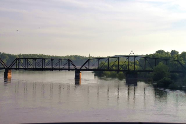
This bridge has a long, complicated history that includes collapses twice in its history. Historical photos of an unknown date show the main swing span of the bridge collapsed. As such, the construction date given for this bridge may refer to the approach spans and not the main swing span, if it was replaced after the collapse rather than repaired. If it was replaced, it was replaced with a bridge of similar design and appearance. The bridge was abandoned in 1996. Over the time of the bridge's active service some spans including an unusual lightweight pin connected pony truss span. In 2005 disaster struck again when the abandoned bridge lost some spans due to flooding. In fact the river appears to have shifted since this bridge was built as the swing span is off to the side in a shallow area with sand. The spans that remain standing today are old, lightweight (for railroad) spans that deserve to perhaps be relocated and preserved elsewhere in a park or on a trail for example.
The spans of the bridge are as follows:
From east to west: Timber stringer approach, One 95ft. through girder span (built post 1945; originally 3-panel, pin-connected Pratt Pony truss), one 238ft pin-connected Pratt through truss swing span, four 157 ft. 8-panel, pin-connected Pratt through truss spans (two westernmost spans destroyed), six steel stringer spans (built 1972; originally timber stringers), timber stringer approach.
Currently only a few photos taken from nearby I-64 are available. See BridgeHunter for additional photos.
Below: Historical photos showing the collapse of the swing span.


This bridge is tagged with the following special condition(s): Unorganized Photos
![]()
![]()
![]()
Coordinates (Latitude, Longitude):
Search For Additional Bridge Listings:
Bridgehunter.com: View listed bridges within 0.5 miles (0.8 kilometers) of this bridge.
Bridgehunter.com: View listed bridges within 10 miles (16 kilometers) of this bridge.
Additional Maps:
Google Streetview (If Available)
GeoHack (Additional Links and Coordinates)
Apple Maps (Via DuckDuckGo Search)
Apple Maps (Apple devices only)
Android: Open Location In Your Map or GPS App
Flickr Gallery (Find Nearby Photos)
Wikimedia Commons (Find Nearby Photos)
Directions Via Sygic For Android
Directions Via Sygic For iOS and Android Dolphin Browser
USGS National Map (United States Only)
Historical USGS Topo Maps (United States Only)
Historic Aerials (United States Only)
CalTopo Maps (United States Only)

© Copyright 2003-2026, HistoricBridges.org. All Rights Reserved. Disclaimer: HistoricBridges.org is a volunteer group of private citizens. HistoricBridges.org is NOT a government agency, does not represent or work with any governmental agencies, nor is it in any way associated with any government agency or any non-profit organization. While we strive for accuracy in our factual content, HistoricBridges.org offers no guarantee of accuracy. Information is provided "as is" without warranty of any kind, either expressed or implied. Information could include technical inaccuracies or errors of omission. Opinions and commentary are the opinions of the respective HistoricBridges.org member who made them and do not necessarily represent the views of anyone else, including any outside photographers whose images may appear on the page in which the commentary appears. HistoricBridges.org does not bear any responsibility for any consequences resulting from the use of this or any other HistoricBridges.org information. Owners and users of bridges have the responsibility of correctly following all applicable laws, rules, and regulations, regardless of any HistoricBridges.org information.
![]()