We Recommend:
Bach Steel - Experts at historic truss bridge restoration.
BridgeHunter.com Phase 1 is released to the public! - Visit Now
Whiting Park Bridge

Primary Photographer(s): Nathan Holth
Bridge Documented: December 12, 2012
Whiting: Lake County, Indiana: United States
By Builder/Contractor: Unknown
Not Available or Not Applicable
Not Available
Not Available
Not Available
1 Main Span(s)
Not Applicable

View Information About HSR Ratings
Bridge Documentation
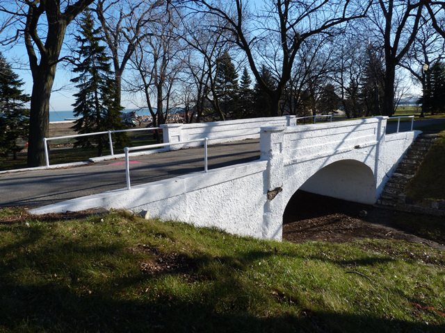
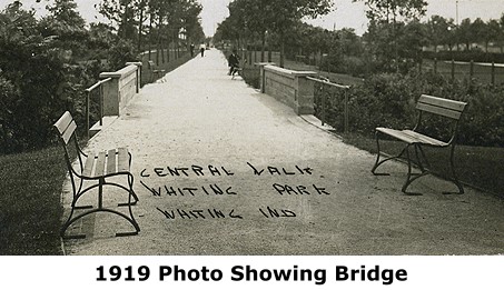
Whiting Park is a large lakeshore park that was created in the early 20th Century. This tiny concrete arch foot bridge was apparently constructed to serve what was known as the "Central Walkway" in the park. The exact year of the bridge's construction is unknown, although it appears in a 1919 photo, so obviously dates to 1919 or before. The bridge crosses over what is today a small depression. Stairs beside the bridge lead down to this depression, which itself leads to the entrance to nearby tennis courts. The exact original purpose of the bridge is unknown. The tiny depression it crosses could easily have been filled in. Perhaps long ago there was a small drain or creek that is today gone. Perhaps the bridge was built simply for the aesthetic value of having a bridge. The historical photo of the bridge from 1919 shows bushes and other growth in the depression, similar to what one might expect along a small creek or drain. Whatever the case, there is nothing of importance going under the bridge aside from the slight depression. Despite this fact, the bridge is a beautiful and historic structure for the park. Not only does it add beauty to the park, it helps identify the park as something that has been a part of Whiting for many decades. The bridge appears to have suffered from isolated deterioration and spalling. It has been protected by a concrete sealant. The bridge retains excellent historic integrity with no alterations noted. The bridge itself has solid concrete parapet style railings, while pipe railings provide an approach to the bridge. The pipe railings are a somewhat unusual addition to a bridge, particularly one in a park setting because they do not harmonize very well with an all-concrete bridge with concrete parapet railings. However, they do appear to be an original detail since they appear in the 1919 photo of the bridge.
Whiting has been working on a plan to bring substantial improvements and changes to the park. It is hoped that this historic bridge will not fall through the cracks and will be retained and restored as needed.
![]()
Photo Galleries and Videos: Whiting Park Bridge
Bridge Photo-Documentation
Original / Full Size PhotosA collection of overview and detail photos. This gallery offers photos in the highest available resolution and file size in a touch-friendly popup viewer.
Alternatively, Browse Without Using Viewer
![]()
Bridge Photo-Documentation
Mobile Optimized PhotosA collection of overview and detail photos. This gallery features data-friendly, fast-loading photos in a touch-friendly popup viewer.
Alternatively, Browse Without Using Viewer
![]()
Maps and Links: Whiting Park Bridge
Coordinates (Latitude, Longitude):
Search For Additional Bridge Listings:
Bridgehunter.com: View listed bridges within 0.5 miles (0.8 kilometers) of this bridge.
Bridgehunter.com: View listed bridges within 10 miles (16 kilometers) of this bridge.
Additional Maps:
Google Streetview (If Available)
GeoHack (Additional Links and Coordinates)
Apple Maps (Via DuckDuckGo Search)
Apple Maps (Apple devices only)
Android: Open Location In Your Map or GPS App
Flickr Gallery (Find Nearby Photos)
Wikimedia Commons (Find Nearby Photos)
Directions Via Sygic For Android
Directions Via Sygic For iOS and Android Dolphin Browser
USGS National Map (United States Only)
Historical USGS Topo Maps (United States Only)
Historic Aerials (United States Only)
CalTopo Maps (United States Only)


