

View Information About HSR Ratings
This is one of an impressive number of concrete arch bridges documented in Fort Wayne. A riveted plate girder railroad overpass is located west of this bridge, and a few photos are included in the gallery.

Above: Historical postcard of bridge.

Above: Historical photo showing previous bridge at location.

Above: Historical photo showing previous bridge at location.
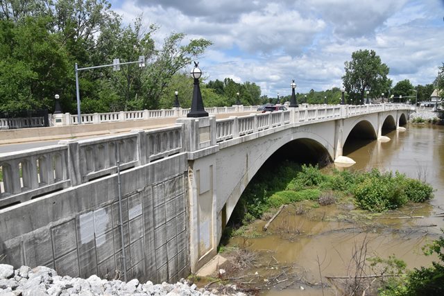
Information and Findings From DHPA Historic Bridge SurveyBridge History and Significance Previous Structures (c. 1812) "A drawing from a woodcut in Lassing's 'Pictorial Fieldbook of the War of 1812' showing the wooden timber trestle and kingpost bridge across the Maumee directly below the confluence of the St. Mary's and the St. Joseph river, which connected the town of Fort Wayne with the present Lakeside, then known as the old apple orchard." (1863 - 1894) S2/T30N/12E Gould reported the presence of a covered timber bridge on East Main Street over the Maumee River of about 300-foot length between 1863 and about 1890. A fire in 1888 badly damaged the superstructure, but repairs were completed within a month. On 15 April 1889, the city decided to construct an iron bridge just north at Columbia Street. The relocated site caused court action which ultimately confirmed the new location and construction was completed in 1890. Camelback through-truss (1894 - 1926) The commissioners received and rejected the first set of bids in February 1889. They opened a second set of 13 proposals in March and selected that of the Milwaukee Bridge Company for a 300-foot span for $23,900. The biggest contest was over the exact location of the bridge. Several locally prominent people who owned property on the east end of Columbia street likely tipped the balance towards a relocation -- extending Columbia street east and Clay street north -- by reporting they would likely put up new commercial buildings if the street were extended. A blue-print drawing of the proposed "Camelback" style of construction hung in the commissioners court. "No bridge of its kind is found in Indiana, but they are not uncommon in other states." Surveyed Structure (1926 - ) A. W. Grosvenor designed the Columbia Street Bridge, and the I. E. Smith Construction Company built it for $188,990. The county commissioners ordered the first set of plans for the bridge in February 1913 from Orin M. Darling at the rate of $100 per day for his services. At the July letting, the board received bids based on the "county plans" from Herman Tapp and from the National Concrete Company. National Concrete also submitted a proposal on a Luten design. Dissatisfied with the crop of proposals, the commissioners rejected all and decided to re-advertise. Whether the county invited it, or Grosvenor moved ahead on his own, the September letting included proposals on two Grosvenor designs. It was on the basis of one of the Grosvenor designs that I. E. Smith won the competition. The letting was not settled in a board meeting. The Allen County Superior Count issued a restraining order and injunction against construction, apparently over the proposed western terminus of the bridge. The Fort Wayne News-Sentinel weighed into this and other bridge issues in 1922 with a series of articles entitled "Building Fort Wayne." The newspaper editors argued for city planning in the context of the City Beautiful movement and suggested in June that "the proposed bridge at Columbia street would be the most important work of its kind ever undertaken by Allen county." In August, the newspaper reported on a town meeting of the Reds and the Whites over "The Anthony Wayne bridge." "The 'Whites,' from the court-house and city hall, were seated on the platform; the 'Reds,' from all over Kekionga, stood up in front of the platform in true Indian style." "'We want that bridge!' cried the Indians in response to a signal from the chairman." All agreed that the Columbia street bridge was unsafe and should be replaced before it collapsed. The Fort Wayne News-Sentinel also called for a City-Beautiful park and parkway to run along the north side of the Maumee River from the new Columbia Street Bridge to the New Haven crossing. Negotiation led over time to a supplementary contract with Smith and the rescheduling of construction for 1925-1926. The county turned to Grosvenor for plans for a footbridge across the Maumee "at the time the old steel bridge is blocked off for construction of the new bridge. I. E. Smith secured a $4,690 contract for construction of the footbridge in February 1926. As originally designed, the bridge carried a 40-foot roadway flanked by an 8-foot sidewalk on each side. The distance between the 20 Melan-system girders in each ring varied. The most central eight were placed 2.5 feet apart. The next two pairs on each side at 3 feet, and the final pair on each side at 3-feet and 2-inches from one to another. The pier-pilaster decor was extended into the parapet rail posts. The parapets were coped and carried open-arch panels. This long and wide structure is of rather standard design. Replacement of the original deck in 1972 with a cantilevered concrete one required the removal of the original parapet rails and lighting without destroying -- while obscuring -- the rest of the structure's architectural integrity. In 2002, the metal replacement rails and lighting (1972) were again replaced -- most recently with open-arch panel concrete rails and period lights. References (1863 - 1894) George Gould, Indiana
Covered Bridges Thru the Years, (Indianapolis, 1977), 20, 28-29, 48.
(1894 - 1926) "The New Bridge," "Bridge Business," "Entered Into
Contract," "Bridge Contracts Let," Ft. Wayne Morning Journal, 30 March
1889: p4 c4; 3 April 1889: p4 c4; 11 April 1889: p4 c4. (1926 - )
Butler, Fairman & Seufert, Inc., Bridge Inspection/Reinspection Report:
Allen County (Indianapolis, 1973, 1977, 1981). SIECO, Inc., Bridge
Reinspection Report: Allen County (Columbus, 1993, 1995). Farrar, Garvey
and Associates, Inc., Bridge Inspection Report: Allen County
(Indianapolis, 1997, 1999, 2004). bridge nameplate. Allen County,
"Commissioners Record," 16: 5-6, 8, 27, 32, 35, 40, 118, 124a, 131-132,
166-170, 462; 17: 59-60, 123, 127-128, 280; "Old Bridges" (Surveyor's
Office), 13E: 10. "Fort Wayne - Bridge - Allen County," Construction
News, Engineering News-Record, 28 June 1923: 382; 23 August 1923: 102;
27 September 1923: 177. James L. Cooper, "A Plea for City-Beautiful
Context-Sensitive Bridge Design, 'Building Fort Wayne,' The Fort Wayne
News-Sentinel (1922)." Bridge Considered Historic By Survey: Yes |
![]()
![]()
![]()
Coordinates (Latitude, Longitude):
Search For Additional Bridge Listings:
Bridgehunter.com: View listed bridges within 0.5 miles (0.8 kilometers) of this bridge.
Bridgehunter.com: View listed bridges within 10 miles (16 kilometers) of this bridge.
Additional Maps:
Google Streetview (If Available)
GeoHack (Additional Links and Coordinates)
Apple Maps (Via DuckDuckGo Search)
Apple Maps (Apple devices only)
Android: Open Location In Your Map or GPS App
Flickr Gallery (Find Nearby Photos)
Wikimedia Commons (Find Nearby Photos)
Directions Via Sygic For Android
Directions Via Sygic For iOS and Android Dolphin Browser
USGS National Map (United States Only)
Historical USGS Topo Maps (United States Only)
Historic Aerials (United States Only)
CalTopo Maps (United States Only)

© Copyright 2003-2025, HistoricBridges.org. All Rights Reserved. Disclaimer: HistoricBridges.org is a volunteer group of private citizens. HistoricBridges.org is NOT a government agency, does not represent or work with any governmental agencies, nor is it in any way associated with any government agency or any non-profit organization. While we strive for accuracy in our factual content, HistoricBridges.org offers no guarantee of accuracy. Information is provided "as is" without warranty of any kind, either expressed or implied. Information could include technical inaccuracies or errors of omission. Opinions and commentary are the opinions of the respective HistoricBridges.org member who made them and do not necessarily represent the views of anyone else, including any outside photographers whose images may appear on the page in which the commentary appears. HistoricBridges.org does not bear any responsibility for any consequences resulting from the use of this or any other HistoricBridges.org information. Owners and users of bridges have the responsibility of correctly following all applicable laws, rules, and regulations, regardless of any HistoricBridges.org information.
![]()