


View Information About HSR Ratings
This bridge is also noted as a rare surviving example of a bridge built by the St. Louis Bridge Company. The bridge was moved off of the old National Road alignment after a concrete arch bridge was built as a new National Road Bridge in 1925. This bridge is just around the corner from the concrete arch bridge on CR-570 South, which is the old National Road alignment prior to US-40's current alignment. At this location on CR-25 East, the truss bridge replaced an 1884 covered bridge.
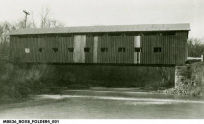
Above: Historical photo showing previous bridge at this location.
Information and Findings From DHPA Historic Bridge SurveyBridge History and Significance Prior Location: the National Road According to anecdotal oral reports, travelers on the National Road forded Deer Creek before the construction of a metal-truss bridge in Section 10 of Warren township. Although George Gould did not suggest the presence of a covered timber-truss bridge here, his findings do not rule out possible simple timber beam structures. In any case, early Putnam county records have not been searched to determine the presence or absence of spans extant before 1890. In 1890, J. C. Cooper petitioned for the construction of a bridge to carry the National Road across Deer Creek, and the county commissioners agreed in early 1891 to have two stone abutments and a single-span superstructure erected under the supervision of J. T. Ohran. In May, the St. Louis Bridge Company proposed to build an "iron superstructure bridge" for $1,827, and John and Timothy Murphy won the contract for its cut-stone abutments at $5 per cubic yard for the masonry. Murphy and Murphy received periodic payments for their stonework from May through September. The limestone for the substructure probably came from a quarry in Putnam county. The St. Louis Bridge Company got its first payment for the superstructure in October, and John M. Hendrix was allowed a small sum for the furnishing of stone and O. W. Bridges for work on the fill in November. It appears that the new bridge was in service before the end of 1891. While the Cooper Bridge sat perpendicular to Deer Creek, the old National Road ran almost perpendicular to the bridge on both ends, making for sharp turns on and off the bridge. The approaches to the bridge did not prove much of an issue in the era of wagon traffic, but the automotive age made new demands on roadways and bridges. In 1913, for example, the owner of a Ford "machine" crossed the Cooper Bridge at too high a speed to negotiate "the sharp turn east of the bridge." The Ford rolled down the 12-foot embankment and turned over two times without hurting any of the three occupants. The county periodically repaired the bridge. In June 1921, for instance, it awarded James Mahoney a $1,484 contract for repair work and named Fred Fisher to superintend the same. The work was satisfactorily completed by October. In 1923 -- after the National Road became a part of the state highway system -- the state straightened the road and bypassed Cooper bridge with an open-spandrel reinforced-concrete arch structure, itself bypassed in less than twenty years #1835 when U.S. #40 was four-laned in preparation for World War II. Surveyed Location: Boesen Road or County Route 25E Putnam County's careful commissioners saw the abandoned iron bridge as an opportunity. They offered and paid the state $1 for the span in 1927 and contracted with Alonzo Day to tear down, remove, and reconstruct on new abutments around the corner on Boesen Road for $4,350. Another generation of the Cooper family, Alfred, superintended the move. The approaches were constructed in October. The designer's intentions were not entirely followed by the bridge movers, for the sizes of all verticals do not now completely match from truss to truss. In addition, the original variable-depth girder floor-beams were replaced with rolled I sections as a part of the relocation. The Cooper Bridge superstructure is the only surviving metal-truss bridge to have once stood on the National Road in Indiana. The Pratt through trusses are conventionally designed, despite the unusual installation of the verticals, likely in the process of relocation. The variously configured original truss members still function, including the latticed portals. References Butler, Fairman and Seufert, Inc., Bridge Inspection/Reinspection Report: Putnam County (Indianapolis, 1974, 1978). Indiana State Highway Commission, Bridge Survey, 2: 10-30; 759: 53-54. George Gould, Indiana Covered Bridges Thru the Years (Indianapolis, 1977), 59-60. Indiana Historic Sites & Structures Inventory, Putnam County: Interim Report (Indianapolis, 1982), 46-47. "Auto Party Has Narrow Escape," "Notice of Bridge Letting," "Notice to Contractors," Greencastle Herald, 2 July 1913: p4 c1-2; 21 March 1927: p2c4; 6 September 1927: p2c1-3. Putnam County, "Commissioners Record," 13: 102, 240, 267-268, 320, 351-352, 357; 23: 501, 515, 527, 550; 25: 243, 309, 332, 376, 428. Bridge Considered Historic By Survey: Yes |
![]()
![]()
![]()
Coordinates (Latitude, Longitude):
Search For Additional Bridge Listings:
Bridgehunter.com: View listed bridges within 0.5 miles (0.8 kilometers) of this bridge.
Bridgehunter.com: View listed bridges within 10 miles (16 kilometers) of this bridge.
Additional Maps:
Google Streetview (If Available)
GeoHack (Additional Links and Coordinates)
Apple Maps (Via DuckDuckGo Search)
Apple Maps (Apple devices only)
Android: Open Location In Your Map or GPS App
Flickr Gallery (Find Nearby Photos)
Wikimedia Commons (Find Nearby Photos)
Directions Via Sygic For Android
Directions Via Sygic For iOS and Android Dolphin Browser
USGS National Map (United States Only)
Historical USGS Topo Maps (United States Only)
Historic Aerials (United States Only)
CalTopo Maps (United States Only)

© Copyright 2003-2025, HistoricBridges.org. All Rights Reserved. Disclaimer: HistoricBridges.org is a volunteer group of private citizens. HistoricBridges.org is NOT a government agency, does not represent or work with any governmental agencies, nor is it in any way associated with any government agency or any non-profit organization. While we strive for accuracy in our factual content, HistoricBridges.org offers no guarantee of accuracy. Information is provided "as is" without warranty of any kind, either expressed or implied. Information could include technical inaccuracies or errors of omission. Opinions and commentary are the opinions of the respective HistoricBridges.org member who made them and do not necessarily represent the views of anyone else, including any outside photographers whose images may appear on the page in which the commentary appears. HistoricBridges.org does not bear any responsibility for any consequences resulting from the use of this or any other HistoricBridges.org information. Owners and users of bridges have the responsibility of correctly following all applicable laws, rules, and regulations, regardless of any HistoricBridges.org information.
![]()