

View Information About HSR Ratings
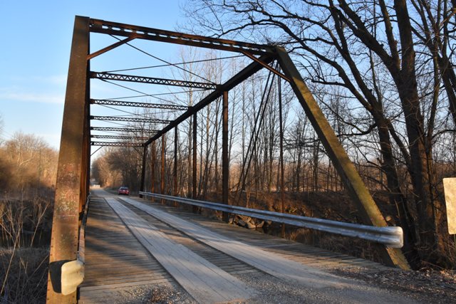
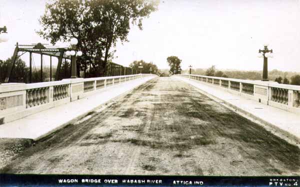
This bridge was originally built in 1886 as part of a seven span highway bridge in Attica, Indiana. In 1924, that bridge was replaced by a concrete arch bridge (see below historical photo). The 1886 truss spans were not demolished however, and instead were relocated and reused in various locations in Indiana. Several of these reused spans remain today, and this is one of them.
The spans have unusual design details including four-prong eyebars for the upper lateral bracing. Another unusual detail is that the fishbelly floorbeams are not hung from the bottom chord by u-bolts (as was typical in 1886), but are instead field bolted to the verticals. It is not known if this is original, or might be an alteration from the relocation.
HistoricBridges.org has documented another one of the Attica Bridge spans, the Hushaw Bridge. Visit that page for a more detailed DHPA history of the bridge.
This particular span had an unfortunate vehicular accident of some sort that damaged the end post, part of the bottom chord, and the hip vertical, all at the southeast corner. It also tore the modern Armco guardrail from the verticals on the south side of the truss. These damaged items were replaced by the county, with work nearly complete when visited by HistoricBridges.org in 2017. The attempt to replicate the endpost of this bridge is truly remarkable, in a bad sense. An attempt was made to replicate the riveted design of the end post. But instead of replicating it in-kind using riveted construction (as is typical in Indiana which is a leading state for good preservation practice), the county hired someone to make a welded end post. What is truly remarkable is that they took genuine rivets, but instead of actually heating and driving the rivets, they stuck them into the holes, cut off the field end, and welded it flat with the end post channel flange. So only the shop head of the rivet is visible on the cover plate. Because the rivets are just decorative in this manner, welding of all the v-lacing and cover plate was required. The end result is an endpost that looks really silly to anyone with a basic knowledge of historic bridges. Furthermore, it is difficult to imagine how incredibly time-consuming it must have been to cut off all the rivets and weld the ends to the channel flange. It would have taken a tiny fraction of the time to simply heat and drive real rivets, avoiding all the welding, and the end product would have looked exactly like the original. So the new welded endpost cost a lot more time (and presumably money) and the end product does not even look all that nice.
Information and Findings From DHPA Historic Bridge SurveyStatement of Significance This single-span, pin-connected Pratt through truss is seated upon concrete abutments and wingwalls. Intermediate verticals of laced channels subdivide the 134' truss into most of its eight panels. Eyebars provide the diagonals: pairs stretch toward center span from the top panel point to the bottom of all except the endpost panels; cylindrical eyebars with turnbuckles counter the others in the two most central panels. The outer two panels of the lower chord use heavy connected channels. Attached to the verticals above the lower pins, girder floor-beams carry the renovated stringers and timber deck with 14'9" of vertical roadway clearance. Except for elements of the deck renovated in 1924, the bridge retains its original members, including decoratively latticed portals. Placing the lower chord below the floor-beams and using channels in some lower chord panels represent some variation from the standard design of the truss. Other Information References H. Stewart Kline & Associates, Inc., Bridge Inspection Report: Fountain County (Lafayette, 1973). Reid, Quebe, et al., Bridge Inventory & Safety Inspection: Fountain County (Indianapolis, 1979). Beam, Longest & Neff, Fountain County: Bridge Inventory Rating and Safety Inspection (Indianapolis, 2002); Fountain County: Fracture Critical Inspection Report (Indianapolis, 2006). Bridge Considered Historic By Survey: Yes |
![]()
![]()
![]()
Coordinates (Latitude, Longitude):
Search For Additional Bridge Listings:
Bridgehunter.com: View listed bridges within 0.5 miles (0.8 kilometers) of this bridge.
Bridgehunter.com: View listed bridges within 10 miles (16 kilometers) of this bridge.
Additional Maps:
Google Streetview (If Available)
GeoHack (Additional Links and Coordinates)
Apple Maps (Via DuckDuckGo Search)
Apple Maps (Apple devices only)
Android: Open Location In Your Map or GPS App
Flickr Gallery (Find Nearby Photos)
Wikimedia Commons (Find Nearby Photos)
Directions Via Sygic For Android
Directions Via Sygic For iOS and Android Dolphin Browser
USGS National Map (United States Only)
Historical USGS Topo Maps (United States Only)
Historic Aerials (United States Only)
CalTopo Maps (United States Only)

© Copyright 2003-2025, HistoricBridges.org. All Rights Reserved. Disclaimer: HistoricBridges.org is a volunteer group of private citizens. HistoricBridges.org is NOT a government agency, does not represent or work with any governmental agencies, nor is it in any way associated with any government agency or any non-profit organization. While we strive for accuracy in our factual content, HistoricBridges.org offers no guarantee of accuracy. Information is provided "as is" without warranty of any kind, either expressed or implied. Information could include technical inaccuracies or errors of omission. Opinions and commentary are the opinions of the respective HistoricBridges.org member who made them and do not necessarily represent the views of anyone else, including any outside photographers whose images may appear on the page in which the commentary appears. HistoricBridges.org does not bear any responsibility for any consequences resulting from the use of this or any other HistoricBridges.org information. Owners and users of bridges have the responsibility of correctly following all applicable laws, rules, and regulations, regardless of any HistoricBridges.org information.
![]()