

View Information About HSR Ratings
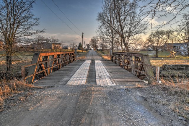
This is a traditional riveted pony truss bridge in a rural agricultural setting.
Information and Findings From DHPA Historic Bridge SurveyStatement of Significance This bridge looks a lot like an Indiana Department of Highways' Warren pony span design for the early 1930s. Its trusses are half-hip, five-paneled, and riveted. They span 60' between concrete abutments and wingwalls. The diagonals are heavier at the endposts than at center span. They are made from two pairs of angles and battens for each outer panel and a single, increasingly lighter pair towards midspan. The lower-chord members are also varied in size, each being fabricated from a pair of angles and battens at the endpost panels and from two pairs for the inner ones. The verticals consist of two pairs of angles and some battens shared with the external braces. The I floor-beams are riveted to gussets and the verticals above the lower chord and carry a timber deck with an 18'8" roadway. Narrow-channel guardrails protect the trusses. The design of this structure suggests some transition from patterns which the IDH established for its Warren pony truss spans in the 1920s. The stiffening of the outer diagonals and inner lower-chord members reflect bits of evolutionary change, although the deck is more narrow and built for slower traffic than typically found on a state highway of the 1930s. Other Information References H. Stewart Kline & Associates, Inc., Bridge Inspection Report: Fountain County (Lafayette, 1973). Reid, Quebe, et al., Bridge Inventory & Safety Inspection: Fountain County (Indianapolis, 1979). Crowder & Darnall, Inc., Bridge Inventory & Safety Inspection: Fountain County (Columbus, 1986). Beam, Longest & Neff, Fountain County: Bridge Inventory Rating and Safety Inspection (Indianapolis, 2002); Fountain County: Fracture Critical Inspection Report (Indianapolis, 2006). Bridge Considered Historic By Survey: Yes |
![]()
![]()
![]()
Coordinates (Latitude, Longitude):
Search For Additional Bridge Listings:
Bridgehunter.com: View listed bridges within 0.5 miles (0.8 kilometers) of this bridge.
Bridgehunter.com: View listed bridges within 10 miles (16 kilometers) of this bridge.
Additional Maps:
Google Streetview (If Available)
GeoHack (Additional Links and Coordinates)
Apple Maps (Via DuckDuckGo Search)
Apple Maps (Apple devices only)
Android: Open Location In Your Map or GPS App
Flickr Gallery (Find Nearby Photos)
Wikimedia Commons (Find Nearby Photos)
Directions Via Sygic For Android
Directions Via Sygic For iOS and Android Dolphin Browser
USGS National Map (United States Only)
Historical USGS Topo Maps (United States Only)
Historic Aerials (United States Only)
CalTopo Maps (United States Only)

© Copyright 2003-2025, HistoricBridges.org. All Rights Reserved. Disclaimer: HistoricBridges.org is a volunteer group of private citizens. HistoricBridges.org is NOT a government agency, does not represent or work with any governmental agencies, nor is it in any way associated with any government agency or any non-profit organization. While we strive for accuracy in our factual content, HistoricBridges.org offers no guarantee of accuracy. Information is provided "as is" without warranty of any kind, either expressed or implied. Information could include technical inaccuracies or errors of omission. Opinions and commentary are the opinions of the respective HistoricBridges.org member who made them and do not necessarily represent the views of anyone else, including any outside photographers whose images may appear on the page in which the commentary appears. HistoricBridges.org does not bear any responsibility for any consequences resulting from the use of this or any other HistoricBridges.org information. Owners and users of bridges have the responsibility of correctly following all applicable laws, rules, and regulations, regardless of any HistoricBridges.org information.
![]()