
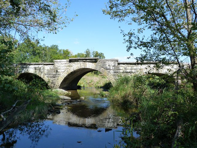

View Information About HSR Ratings
This bridge is largely unaltered, something that cannot be said for all of the many stone arch bridges in this area. Its multi-span configuration, along with a center span that is a foot longer with a two foot higher rise, gives the bridge an attractive, appearance that is varied yet symmetrical. Historic bridge survey research found information that indicated that one of three bridges over Sand Creek dates to 1872. If it turned out to be this one, this bridge would be among the older of the stone arch bridges in this area, since a fair number date to as late as the early 20th Century. The generic 1890 date in the National Bridge Inventory is used for a bunch of the stone arch bridges in this area and is almost certainly incorrect.
Information and Findings From DHPA Historic Bridge SurveyStatement of Significance Although all three arches are segmental, the central one comes close to being a semicircular one. The bridge's design, therefore, moved cautiously away from the standard. Very few of Decatur County's segmental arches are multispan. Architectural Description Local craftsmen built most of Indiana's stone arches from regional materials just before or in the first fifteen years of the twentieth century. Most stonemasons preferred full-centered or semicircular arches in
which the line of pressure passes through the center of each stone in the arch ring until carried vertically into the substructure. In some cases, though, masons erected segmental arches in which the intrados is less than half a
circle. To function successfully, segmental arches require the substructure to accommodate some horizontal as well as some vertical pressure. Other Information In March 1872, the Decatur board appropriated $500 as a contribution to the Sand Creek Turnpike Company to aid in "constructing a bridge across Sand Creek on their road." The appropriation could have applied to #114, #118, or #190. Bridge Considered Historic By Survey: Yes |
![]()
![]()
![]()
Coordinates (Latitude, Longitude):
Search For Additional Bridge Listings:
Bridgehunter.com: View listed bridges within 0.5 miles (0.8 kilometers) of this bridge.
Bridgehunter.com: View listed bridges within 10 miles (16 kilometers) of this bridge.
Additional Maps:
Google Streetview (If Available)
GeoHack (Additional Links and Coordinates)
Apple Maps (Via DuckDuckGo Search)
Apple Maps (Apple devices only)
Android: Open Location In Your Map or GPS App
Flickr Gallery (Find Nearby Photos)
Wikimedia Commons (Find Nearby Photos)
Directions Via Sygic For Android
Directions Via Sygic For iOS and Android Dolphin Browser
USGS National Map (United States Only)
Historical USGS Topo Maps (United States Only)
Historic Aerials (United States Only)
CalTopo Maps (United States Only)

© Copyright 2003-2025, HistoricBridges.org. All Rights Reserved. Disclaimer: HistoricBridges.org is a volunteer group of private citizens. HistoricBridges.org is NOT a government agency, does not represent or work with any governmental agencies, nor is it in any way associated with any government agency or any non-profit organization. While we strive for accuracy in our factual content, HistoricBridges.org offers no guarantee of accuracy. Information is provided "as is" without warranty of any kind, either expressed or implied. Information could include technical inaccuracies or errors of omission. Opinions and commentary are the opinions of the respective HistoricBridges.org member who made them and do not necessarily represent the views of anyone else, including any outside photographers whose images may appear on the page in which the commentary appears. HistoricBridges.org does not bear any responsibility for any consequences resulting from the use of this or any other HistoricBridges.org information. Owners and users of bridges have the responsibility of correctly following all applicable laws, rules, and regulations, regardless of any HistoricBridges.org information.
![]()