We Recommend:
Bach Steel - Experts at historic truss bridge restoration.
BridgeHunter.com Phase 1 is released to the public! - Visit Now
Harris City Bridge
Decatur County Bridge 117

Primary Photographer(s): Nathan Holth and Rick McOmber
Bridge Documented: September 22, 2012
Rural: Decatur County, Indiana: United States
1992
23.6 Feet (7.2 Meters)
50.5 Feet (15.4 Meters)
25 Feet (7.62 Meters)
2 Main Span(s)
1600095

View Information About HSR Ratings
Bridge Documentation
View Archived National Bridge Inventory Report - Has Additional Details and Evaluation
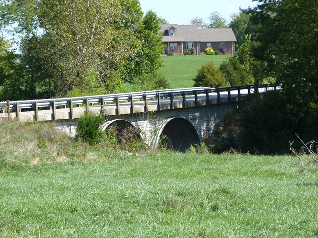
This is one of a substantial number of stone arch bridges in this region, which is also the only region in Indiana that has any noteworthy number of stone arch bridges. This particular example has sadly been substantially altered and thus has poor historic integrity today. The original railings have been lost, the deck being replaced with a concrete slab that cantilevers out beyond the spandrel walls and has modern Armco guardrail on it. Some of the spandrel wall has been replaced with concrete. Also, corrugated steel has been added to the arch ring. The corrugated steel extends outward slightly beyond the spandrel wall, and as such it obstructs the view of the stone arch ring from most viewing angles.
Information and Findings From DHPA Historic Bridge SurveyOther Information Decatur's commissioners contracted with George Bussell Company in May 1892 for "a double arch stone bridge" near Harris City. The contract was drawn in rates per cubic yard for excavation ($.25) and masonry
($2.97). In September, Bussell received $1,595.51 for the Muddy Fork structure. In 1904, Joseph A. Stagg received $323 for unspecified repairs to the Harris City Bridge. Four years later, Joseph M. Mathews negotiated at one fell
swoop contracts for the repair of twelve county bridges, including that over Muddy Fork south of Harris City. The repairs to the bridge must have been modest, for Mathews received only $30 at completion within a few days of the
contracting. In response to damages inflicted by the big 1913 flood, the commissioners accepted the plans and specifications which "J. A. Stagg, Engineer," submitted for "reconstruction of a wall" and fill of the "Harris City
bridge." McQueen and Watkins secured a $267 contract for the repair in May, and the county paid them in December. Bridge Considered Historic By Survey: No |
![]()
Photo Galleries and Videos: Harris City Bridge
Bridge Photo-Documentation
Original / Full Size PhotosA collection of overview and detail photos. This gallery offers photos in the highest available resolution and file size in a touch-friendly popup viewer.
Alternatively, Browse Without Using Viewer
![]()
Bridge Photo-Documentation
Mobile Optimized PhotosA collection of overview and detail photos. This gallery features data-friendly, fast-loading photos in a touch-friendly popup viewer.
Alternatively, Browse Without Using Viewer
![]()
Maps and Links: Harris City Bridge
Coordinates (Latitude, Longitude):
Search For Additional Bridge Listings:
Bridgehunter.com: View listed bridges within 0.5 miles (0.8 kilometers) of this bridge.
Bridgehunter.com: View listed bridges within 10 miles (16 kilometers) of this bridge.
Additional Maps:
Google Streetview (If Available)
GeoHack (Additional Links and Coordinates)
Apple Maps (Via DuckDuckGo Search)
Apple Maps (Apple devices only)
Android: Open Location In Your Map or GPS App
Flickr Gallery (Find Nearby Photos)
Wikimedia Commons (Find Nearby Photos)
Directions Via Sygic For Android
Directions Via Sygic For iOS and Android Dolphin Browser
USGS National Map (United States Only)
Historical USGS Topo Maps (United States Only)
Historic Aerials (United States Only)
CalTopo Maps (United States Only)

