

View Information About HSR Ratings
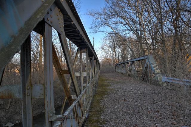
This abandoned variation of a state standard pony truss has one of the greatest possible skews that is possible for a bridge. The skew is listed at an incredible 67 degrees! The end floorbeams do not even reach the opposite truss and instead rest on the abutments. This bridge is today bypassed and abandoned when a bridge was built on new alignment in 1997.
Information and Findings From DHPA Historic Bridge SurveyStatement of Significance The Elkhart Bridge Company of Elkhart, Indiana, erected this structure. Concrete abutments and wingwalls support the one-span Warren pony truss. The riveted structure extends 142' in ten panels with the north truss offset three panels to the west. Its verticals and diagonals are manufactured from pairs of angles riveted to stay plates and reinforced with sway bracing. The I floor-beams are bolted to gussets and the verticals above the lower chord and carry the asphalt-over-timber deck with its 15'8" roadway. A prolific Indiana firm fabricated the longest extant span of its kind. Except for the skew, the design is standard. The structure retains its original members, including latticed guardrails. The Indiana Historical Society holds the plans for the bridge. Other Information References United Consulting Engineers, Inc., Bridge Inspection Study and Report: Madison County (Indianapolis, 1973); Bridge Reinspection Report: Madison County (Indianapolis, 1978). Elkhart Bridge & Iron Company, Drawings, D-591, Indiana Historical Society (Indianapolis). Engineering News, LXXXVI, 3 Aug. 1916, Construction News, 59. Bridge Considered Historic By Survey: Yes |
![]()
![]()
![]()
Coordinates (Latitude, Longitude):
Search For Additional Bridge Listings:
Bridgehunter.com: View listed bridges within 0.5 miles (0.8 kilometers) of this bridge.
Bridgehunter.com: View listed bridges within 10 miles (16 kilometers) of this bridge.
Additional Maps:
Google Streetview (If Available)
GeoHack (Additional Links and Coordinates)
Apple Maps (Via DuckDuckGo Search)
Apple Maps (Apple devices only)
Android: Open Location In Your Map or GPS App
Flickr Gallery (Find Nearby Photos)
Wikimedia Commons (Find Nearby Photos)
Directions Via Sygic For Android
Directions Via Sygic For iOS and Android Dolphin Browser
USGS National Map (United States Only)
Historical USGS Topo Maps (United States Only)
Historic Aerials (United States Only)
CalTopo Maps (United States Only)

© Copyright 2003-2025, HistoricBridges.org. All Rights Reserved. Disclaimer: HistoricBridges.org is a volunteer group of private citizens. HistoricBridges.org is NOT a government agency, does not represent or work with any governmental agencies, nor is it in any way associated with any government agency or any non-profit organization. While we strive for accuracy in our factual content, HistoricBridges.org offers no guarantee of accuracy. Information is provided "as is" without warranty of any kind, either expressed or implied. Information could include technical inaccuracies or errors of omission. Opinions and commentary are the opinions of the respective HistoricBridges.org member who made them and do not necessarily represent the views of anyone else, including any outside photographers whose images may appear on the page in which the commentary appears. HistoricBridges.org does not bear any responsibility for any consequences resulting from the use of this or any other HistoricBridges.org information. Owners and users of bridges have the responsibility of correctly following all applicable laws, rules, and regulations, regardless of any HistoricBridges.org information.
![]()