

View Information About HSR Ratings
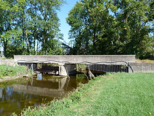
This bridge is a good example of a one-lane concrete through girder. Likely because of its relatively early 1915 construction date as well as its narrow, one-lane design, the bridge has surprisingly lightweight girders that do not look much more massive than one might expect with non-structural bridge railing found on other bridge types like a concrete t-beam bridge. The bridge has articulated floorbeams that are visible under the deck. The historic integrity of the bridge is very good.
Information and Findings From DHPA Historic Bridge SurveyStatement of Significance From a structural perspective, the designer of this bridge produced rather standard through-girder spans. They are, though, unusually well decorated. Architectural Description Because of its greater rigidity, the reinforced concrete through girder can be extended beyond the T-beam's ordinary limit of span (40' - 60' long). In a through structure, a pair of girders - large beams that
receive their loads from other beams - flank the roadway and usually carry the deck above floor beams (which run from girder to girder and whose reinforcing rods are interlocked with those of the girders). The through girder is
preferred where the roadway is not far above stream level and T-beams could obstruct the watercourse more than would girders which do some of their carrying above the level of the road. Bridge Considered Historic By Survey: Yes |
![]()
![]()
![]()
Coordinates (Latitude, Longitude):
Search For Additional Bridge Listings:
Bridgehunter.com: View listed bridges within 0.5 miles (0.8 kilometers) of this bridge.
Bridgehunter.com: View listed bridges within 10 miles (16 kilometers) of this bridge.
Additional Maps:
Google Streetview (If Available)
GeoHack (Additional Links and Coordinates)
Apple Maps (Via DuckDuckGo Search)
Apple Maps (Apple devices only)
Android: Open Location In Your Map or GPS App
Flickr Gallery (Find Nearby Photos)
Wikimedia Commons (Find Nearby Photos)
Directions Via Sygic For Android
Directions Via Sygic For iOS and Android Dolphin Browser
USGS National Map (United States Only)
Historical USGS Topo Maps (United States Only)
Historic Aerials (United States Only)
CalTopo Maps (United States Only)

© Copyright 2003-2025, HistoricBridges.org. All Rights Reserved. Disclaimer: HistoricBridges.org is a volunteer group of private citizens. HistoricBridges.org is NOT a government agency, does not represent or work with any governmental agencies, nor is it in any way associated with any government agency or any non-profit organization. While we strive for accuracy in our factual content, HistoricBridges.org offers no guarantee of accuracy. Information is provided "as is" without warranty of any kind, either expressed or implied. Information could include technical inaccuracies or errors of omission. Opinions and commentary are the opinions of the respective HistoricBridges.org member who made them and do not necessarily represent the views of anyone else, including any outside photographers whose images may appear on the page in which the commentary appears. HistoricBridges.org does not bear any responsibility for any consequences resulting from the use of this or any other HistoricBridges.org information. Owners and users of bridges have the responsibility of correctly following all applicable laws, rules, and regulations, regardless of any HistoricBridges.org information.
![]()