

View Information About HSR Ratings
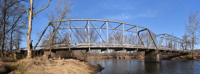
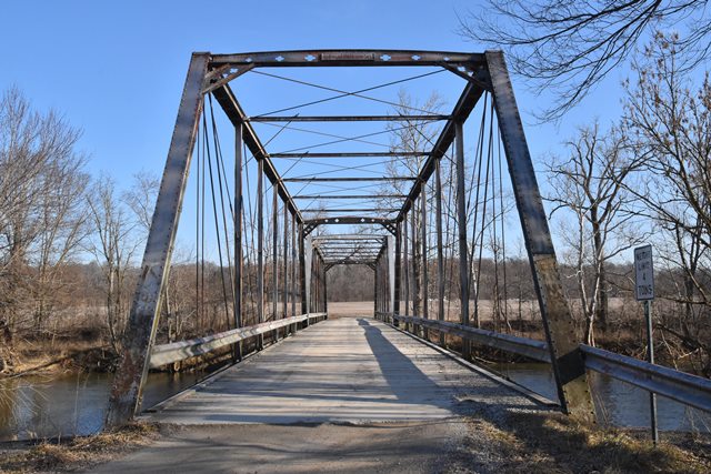
This early and nicely ornamented Pratt truss is one of the finest examples of this once-common type in the area. It features portal bracing ornamentation that the Massillon Bridge Company used on a few bridges in Indiana, but is not typically found on products of the Massillon Bridge Company in other states. The historic integrity of this bridge is excellent.
Information and Findings From DHPA Historic Bridge SurveyStatement of Significance One of the oldest Pratts extant in Indiana and the oldest example of this prolific Ohio firm, the spans retain their integrity including decorated portals and bracing. Architectural Description The Massillon Bridge Company of Massillon, Ohio, fabricated this two-span, pin-connected Pratt through structure of 244' upon cut stone abutments, wingwalls, and pier. Intermediate verticals of two sizes of reinforced I beams subdivide each 122' span into most of its eight panels. Eyebars provide the diagonals: pairs stretch toward center span from the top panel point to the bottom of all except the endpost panels; cylindrical eyebars with turnbuckles counter the others in the three most central panels. Special adjustable eyebars run through the intermediate verticals parallel to and about midway between the chords. U-bolted to the lower pins, heavy and rectangular girder floor-beams carry the timber deck with its 17'7" roadway and 20'5" of vertical clearance. Other Information Bridge nameplate. Butler, Fairman and Seufert, Inc., Bridge Inspection/Reinspection Report: Miami County (Indianapolis, 1973, 1977, 1981). Bridge Considered Historic By Survey: Yes |
![]()
![]()
![]()
Coordinates (Latitude, Longitude):
Search For Additional Bridge Listings:
Bridgehunter.com: View listed bridges within 0.5 miles (0.8 kilometers) of this bridge.
Bridgehunter.com: View listed bridges within 10 miles (16 kilometers) of this bridge.
Additional Maps:
Google Streetview (If Available)
GeoHack (Additional Links and Coordinates)
Apple Maps (Via DuckDuckGo Search)
Apple Maps (Apple devices only)
Android: Open Location In Your Map or GPS App
Flickr Gallery (Find Nearby Photos)
Wikimedia Commons (Find Nearby Photos)
Directions Via Sygic For Android
Directions Via Sygic For iOS and Android Dolphin Browser
USGS National Map (United States Only)
Historical USGS Topo Maps (United States Only)
Historic Aerials (United States Only)
CalTopo Maps (United States Only)

© Copyright 2003-2025, HistoricBridges.org. All Rights Reserved. Disclaimer: HistoricBridges.org is a volunteer group of private citizens. HistoricBridges.org is NOT a government agency, does not represent or work with any governmental agencies, nor is it in any way associated with any government agency or any non-profit organization. While we strive for accuracy in our factual content, HistoricBridges.org offers no guarantee of accuracy. Information is provided "as is" without warranty of any kind, either expressed or implied. Information could include technical inaccuracies or errors of omission. Opinions and commentary are the opinions of the respective HistoricBridges.org member who made them and do not necessarily represent the views of anyone else, including any outside photographers whose images may appear on the page in which the commentary appears. HistoricBridges.org does not bear any responsibility for any consequences resulting from the use of this or any other HistoricBridges.org information. Owners and users of bridges have the responsibility of correctly following all applicable laws, rules, and regulations, regardless of any HistoricBridges.org information.
![]()