

View Information About HSR Ratings
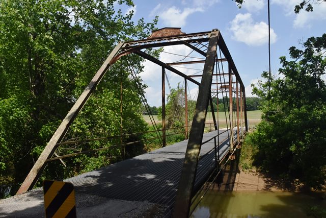
This is a classic example of a Wrought Iron Bridge Company through truss that retains good historic integrity.
Information and Findings From DHPA Historic Bridge SurveyBridge History and Significance Constructed on the old New Albany-Vincennes State Road; at least a second-generation structure at this location. The county engineer drafted detailed specifications for the substructure and general ones for the superstructure. George M. Albertson of Orange County built the substructure. The Wrought Iron Bridge Company of Canton, Ohio, fabricated this single-span, pin-connected Pratt through truss which is seated upon cut stone abutments and wingwalls. Intermediate verticals of crafted I beams divide the 101' truss into most of its six panels. Eyebars provide the diagonals: pairs of adjustable ones stretch toward center span from the top panel point to the bottom of all except the endpost panels; a cylindrical eyebar with a turnbuckle counters the others in the two most central panels. U-bolted to the lower pins, new I floor-beams carry the timber deck with its 11'5" roadway and 16'9" of vertical clearance. Designed by a prolific Ohio firm, this bridge retains many of its original members, including its decoratively latticed portals and portal bracing. Its new floor-beams are welded as well as U-bolted to pin and vertical plates. References Warren T. Hobson & Associates, Bridge Inspection/Reinspection Report: Orange County (Indianapolis, 1974, 1979, 1996). bridge nameplate. Bridge Considered Historic By Survey: Yes |
![]()
![]()
![]()
Coordinates (Latitude, Longitude):
Search For Additional Bridge Listings:
Bridgehunter.com: View listed bridges within 0.5 miles (0.8 kilometers) of this bridge.
Bridgehunter.com: View listed bridges within 10 miles (16 kilometers) of this bridge.
Additional Maps:
Google Streetview (If Available)
GeoHack (Additional Links and Coordinates)
Apple Maps (Via DuckDuckGo Search)
Apple Maps (Apple devices only)
Android: Open Location In Your Map or GPS App
Flickr Gallery (Find Nearby Photos)
Wikimedia Commons (Find Nearby Photos)
Directions Via Sygic For Android
Directions Via Sygic For iOS and Android Dolphin Browser
USGS National Map (United States Only)
Historical USGS Topo Maps (United States Only)
Historic Aerials (United States Only)
CalTopo Maps (United States Only)

© Copyright 2003-2025, HistoricBridges.org. All Rights Reserved. Disclaimer: HistoricBridges.org is a volunteer group of private citizens. HistoricBridges.org is NOT a government agency, does not represent or work with any governmental agencies, nor is it in any way associated with any government agency or any non-profit organization. While we strive for accuracy in our factual content, HistoricBridges.org offers no guarantee of accuracy. Information is provided "as is" without warranty of any kind, either expressed or implied. Information could include technical inaccuracies or errors of omission. Opinions and commentary are the opinions of the respective HistoricBridges.org member who made them and do not necessarily represent the views of anyone else, including any outside photographers whose images may appear on the page in which the commentary appears. HistoricBridges.org does not bear any responsibility for any consequences resulting from the use of this or any other HistoricBridges.org information. Owners and users of bridges have the responsibility of correctly following all applicable laws, rules, and regulations, regardless of any HistoricBridges.org information.
![]()