

View Information About HSR Ratings
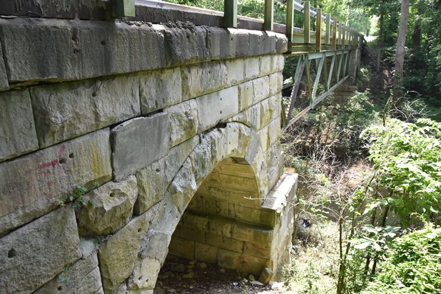
This bridge has a history that is somewhat complicated and uncertain. According to INDOT, this bridge was apparantly built in 1848 as a three span stone arch railroad bridge. Eventually the railroad was abandoned and the grade converted to a highway. At some point, possibly due to an early 20th century flood, the center of the bridge was removed or destroyed, and in 1913 an extremely lightweight looking Warren deck truss was built in the center, while reusing the stone arch approach spans. If the 1848 construction date for the stone arch spans is correct (other sources mentioned an 1890 construction date) these stone arch spans are highly significant as some of the oldest spans surviving in Indiana. As for the main span, Warren deck truss spans of any kind are rare in Indiana, and this lightweight span stands out as unusual. The lack of verticals in a Warren truss is also extremely rare.
Despite being one of the most unique bridges in the area, this historic bridge is likely headed for the dumpster. Indiana generally has one of the best preservation track records in the country. However the planned replacement of this bridge will certainly be a very dark day for Indiana. Located on a quiet rural road, this bridge deserved to be preserved.
Information and Findings From DHPA Historic Bridge SurveyBridge History and Significance The northern and southern stone arch approaches to the single-span Warren deck truss and the cut-stone remnants under the truss suggest that the deck span replaced stone arches that were washed out in the early decades of the century. The metal span is fabricated largely from pairs of angles riveted to each other and to connecting plates. Only in the endposts are channels used; verticals are omitted altogether. Placed above and bolted to the top chord, I floor-beams carry the timber deck with its 12' roadway. This structure probably consists of spans from two different but not widely disconnected decades. Unadorned and apparently intact, the central deck span is one of four Warrens extant in Indiana. References American Consulting Engineers, Inc., Bridge Inspection/Reinspection Report: Martin County (Indianapolis, 1974, 1979). Bridge Considered Historic By Survey: Yes Additional Information From InDOT 14 Tons (H-rating) |
![]()
![]()
![]()
Coordinates (Latitude, Longitude):
Search For Additional Bridge Listings:
Bridgehunter.com: View listed bridges within 0.5 miles (0.8 kilometers) of this bridge.
Bridgehunter.com: View listed bridges within 10 miles (16 kilometers) of this bridge.
Additional Maps:
Google Streetview (If Available)
GeoHack (Additional Links and Coordinates)
Apple Maps (Via DuckDuckGo Search)
Apple Maps (Apple devices only)
Android: Open Location In Your Map or GPS App
Flickr Gallery (Find Nearby Photos)
Wikimedia Commons (Find Nearby Photos)
Directions Via Sygic For Android
Directions Via Sygic For iOS and Android Dolphin Browser
USGS National Map (United States Only)
Historical USGS Topo Maps (United States Only)
Historic Aerials (United States Only)
CalTopo Maps (United States Only)

© Copyright 2003-2025, HistoricBridges.org. All Rights Reserved. Disclaimer: HistoricBridges.org is a volunteer group of private citizens. HistoricBridges.org is NOT a government agency, does not represent or work with any governmental agencies, nor is it in any way associated with any government agency or any non-profit organization. While we strive for accuracy in our factual content, HistoricBridges.org offers no guarantee of accuracy. Information is provided "as is" without warranty of any kind, either expressed or implied. Information could include technical inaccuracies or errors of omission. Opinions and commentary are the opinions of the respective HistoricBridges.org member who made them and do not necessarily represent the views of anyone else, including any outside photographers whose images may appear on the page in which the commentary appears. HistoricBridges.org does not bear any responsibility for any consequences resulting from the use of this or any other HistoricBridges.org information. Owners and users of bridges have the responsibility of correctly following all applicable laws, rules, and regulations, regardless of any HistoricBridges.org information.
![]()