

View Information About HSR Ratings
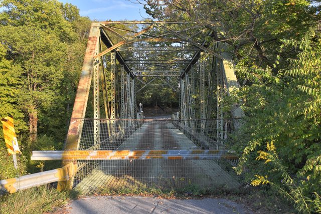
Sitting on the stone substructure of a previous bridge is this attractive through and pony truss combination bridge.
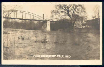
Above: Historical photo showing previous bridge at location.
Information and Findings From DHPA Historic Bridge SurveyBridge History and Significance Previous Structure There was probably a metal-truss bridge over the Flat Rock River at St. Paul before the current structure. The Shelby commissoners, for example, contracted with John Burk in November 1899 to repair about a dozen bridges, including the one at St. Paul for $115. In June 1910, the board employed Haymond and Hammond to clean the St. Paul Bridge with wire brushes and to apply a single coat of paint to the trusses. Surveyed Structure Shelby county sought bids in October 1910 for construction of a steel-truss bridge with a concrete floor over the Flat Rock at St. Paul. The board then contracted with the Lafayette Engineering Company for the superstructure at $4,049. Lafayette Engineering received payment for about half of its contract price in May 1911, at about the same time as Haymond and Howard won a contract for the construction of a concrete abutment and repair of the cut-stone pier. The "Record" shows a small payment of $435 on substructure work and the remainder of its contracted price for the superstructure in July 1911. This single-span, riveted Pratt through truss and Warren pony approach to the south is seated upon one cut stone and one concrete abutment and a stone masonry pier. Intermediate verticals of laced double angles subdivide the through trusses into most of their six panels. Angles riveted together with stay plates provide the lower chord members and the diagonals. There are no counter-braces. The four-panel pony's members are similar to those used on the through. Riveted to the verticals, I floor-beams carry the concrete deck. The through span has 16 feet and 6 inches of vertical roadway clearance. The county included the St. Paul Bridge on the list of structures Ray Heck was to repaint in 1927. These trusses retain their original members. They are unadorned except for decoratively latticed guardrails. References Butler, Fairman and Seufert, Inc., Bridge Inspection Report: Shelby County (Indianapolis, 1973). United Consulting Engineers, Inc., Bridge Reinspection Report For Shelby County (Indianapolis, 1978). SIECO, Inc., Bridge Reinspection Report: Shelby County (Columbus, 1990, 1994). "Construction News," Engineering News, 22 September 1910: 130; 6 October 1910: 155; 20 April 1911: 186. Indiana Historic Sites and Structures Inventory, Shelby County: Interim Report (Indianapolis, 1992), 99, 101. Shelby County, "Commissioners Record," O: 77; R: 576-577; S: 40, 98, 103, 114, 116; T: 512-513. Bridge Considered Historic By Survey: Yes |
![]()
![]()
![]()
Coordinates (Latitude, Longitude):
Search For Additional Bridge Listings:
Bridgehunter.com: View listed bridges within 0.5 miles (0.8 kilometers) of this bridge.
Bridgehunter.com: View listed bridges within 10 miles (16 kilometers) of this bridge.
Additional Maps:
Google Streetview (If Available)
GeoHack (Additional Links and Coordinates)
Apple Maps (Via DuckDuckGo Search)
Apple Maps (Apple devices only)
Android: Open Location In Your Map or GPS App
Flickr Gallery (Find Nearby Photos)
Wikimedia Commons (Find Nearby Photos)
Directions Via Sygic For Android
Directions Via Sygic For iOS and Android Dolphin Browser
USGS National Map (United States Only)
Historical USGS Topo Maps (United States Only)
Historic Aerials (United States Only)
CalTopo Maps (United States Only)

© Copyright 2003-2025, HistoricBridges.org. All Rights Reserved. Disclaimer: HistoricBridges.org is a volunteer group of private citizens. HistoricBridges.org is NOT a government agency, does not represent or work with any governmental agencies, nor is it in any way associated with any government agency or any non-profit organization. While we strive for accuracy in our factual content, HistoricBridges.org offers no guarantee of accuracy. Information is provided "as is" without warranty of any kind, either expressed or implied. Information could include technical inaccuracies or errors of omission. Opinions and commentary are the opinions of the respective HistoricBridges.org member who made them and do not necessarily represent the views of anyone else, including any outside photographers whose images may appear on the page in which the commentary appears. HistoricBridges.org does not bear any responsibility for any consequences resulting from the use of this or any other HistoricBridges.org information. Owners and users of bridges have the responsibility of correctly following all applicable laws, rules, and regulations, regardless of any HistoricBridges.org information.
![]()