

View Information About HSR Ratings
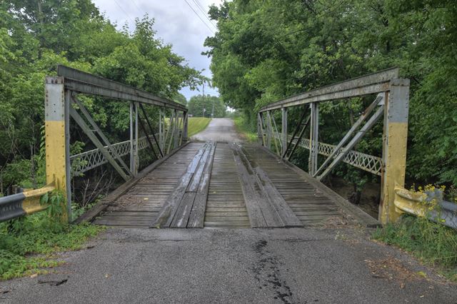
This is an extremely rare rivet-connected bedstead pony truss bridge. It was reportedly moved here from an unknown previous location perhaps in 1987. Looking under the bridge, there is evidence that this bedstead replaced another bedstead truss at this location of a shorter span length. The remains of the bottom of the legs and some concrete from the former abutments are visible under the bridge.
Information and Findings From DHPA Historic Bridge SurveyBridge History and Significance The pin-connected [sic] truss leg or Pratt bedstead pony spans 51' in four panels. The truss legs run to stream level alongside driven I beams now backed by concrete. The wingwalls are made of timber. The vertical endposts and top chords are fabricated of a pair of channels riveted together with a cover plate and battens, the interior verticals of a pair of laced channels, the diagonals of a pair of die-forged eyebars, the center panel's counters of cylindrical rods with turnbuckles, and the outer panel of the lower chord of a pair of angles. U-bolted to the pins, I floor-beams carry the 14' timber deck. The design of these trusses is quite conventional, and the original structure remains intact. 1997 Bridge Inspection Report indicates superstructure relocated to this site (1987?) and reinforced with I-beams added to top chord. References MW, Inc., Warrick County Bridge Re-Inspection Report (Indianapolis, 1978). Engineer Associates, Inc., Bridge Reinspection Report: Warrick County (Evansville, 1981). United Consulting Engineers, Inc., Bridge Reinspection Report: Warrick County (Indianapolis, 1987). WTH Engineering, Warrick County: Bridge Reinspection Report (Indianapolis, 1999). Bridge Considered Historic By Survey: Yes (Select) |
![]()
![]()
![]()
Coordinates (Latitude, Longitude):
Search For Additional Bridge Listings:
Bridgehunter.com: View listed bridges within 0.5 miles (0.8 kilometers) of this bridge.
Bridgehunter.com: View listed bridges within 10 miles (16 kilometers) of this bridge.
Additional Maps:
Google Streetview (If Available)
GeoHack (Additional Links and Coordinates)
Apple Maps (Via DuckDuckGo Search)
Apple Maps (Apple devices only)
Android: Open Location In Your Map or GPS App
Flickr Gallery (Find Nearby Photos)
Wikimedia Commons (Find Nearby Photos)
Directions Via Sygic For Android
Directions Via Sygic For iOS and Android Dolphin Browser
USGS National Map (United States Only)
Historical USGS Topo Maps (United States Only)
Historic Aerials (United States Only)
CalTopo Maps (United States Only)

© Copyright 2003-2025, HistoricBridges.org. All Rights Reserved. Disclaimer: HistoricBridges.org is a volunteer group of private citizens. HistoricBridges.org is NOT a government agency, does not represent or work with any governmental agencies, nor is it in any way associated with any government agency or any non-profit organization. While we strive for accuracy in our factual content, HistoricBridges.org offers no guarantee of accuracy. Information is provided "as is" without warranty of any kind, either expressed or implied. Information could include technical inaccuracies or errors of omission. Opinions and commentary are the opinions of the respective HistoricBridges.org member who made them and do not necessarily represent the views of anyone else, including any outside photographers whose images may appear on the page in which the commentary appears. HistoricBridges.org does not bear any responsibility for any consequences resulting from the use of this or any other HistoricBridges.org information. Owners and users of bridges have the responsibility of correctly following all applicable laws, rules, and regulations, regardless of any HistoricBridges.org information.
![]()