

View Information About HSR Ratings
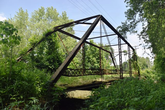
This classic pin-connected truss bridge has been abandoned.
Information and Findings From DHPA Historic Bridge SurveyBridge History and Significance This connector for Mineral City to the Bloomfield-Loogootee road may not have existed much before Richland Creek was spanned. Unfortunately the Greene County "Commissioners Record" is missing for the years around when the bridge was built. Fortunately, the Indiana Bridge Company's records provide us some considerable insight into the erection. In 1907, George M. Notter of Worthington ordered a pair of duplicate structures, one of which he likely erected over Richland Creek on concrete abutments and wing-walls that he had constructed. The hip-verticals of the 16-foot high, pin-connected Pratt through-truss span are hangers; the intermediate ones a pair of laced channels. A pair of die-forged eye-bars provide the diagonal sets for the second and fourth panels. Single, cylindrical rods with turnbuckles supply the diagonal and counter for the center panel. A braced-A portal, intermediate struts, and lateral bracing help to hold the trusses rigid against one. U-bolted to the lower pins, rolled I-floor-beams carry I-beam stringers and the timber roadway. Latticed rails line the trusses. An important bridge-building regional contractor built the substructure of this bridge and erected the superstructure. A prolific Hoosier fabricator used one of its standard designs for these fairly light trusses. The Indiana Bridge Co.'s erection plan for Notter is extant; the structure retains its original members, including latticed guardrails. References Butler, Fairman & Seufert, Inc., Bridge Inspection Report: Greene County (Indianapolis, 1974). M.W., Inc., Bridge Reinspection Report: Greene County (Indianapolis, 1978). United Consulting Engineers, Inc., Bridge Reinspection Report: Greene County (Indianapolis, 1981). Indiana Bridge Co. , contract #6132 or #6196; erection prints for George M. Notter, drawing #2279 (Drawings Archive, College of Architecture, Ball State University). Bridge Considered Historic By Survey: Yes |
![]()
![]()
![]()
Coordinates (Latitude, Longitude):
Search For Additional Bridge Listings:
Bridgehunter.com: View listed bridges within 0.5 miles (0.8 kilometers) of this bridge.
Bridgehunter.com: View listed bridges within 10 miles (16 kilometers) of this bridge.
Additional Maps:
Google Streetview (If Available)
GeoHack (Additional Links and Coordinates)
Apple Maps (Via DuckDuckGo Search)
Apple Maps (Apple devices only)
Android: Open Location In Your Map or GPS App
Flickr Gallery (Find Nearby Photos)
Wikimedia Commons (Find Nearby Photos)
Directions Via Sygic For Android
Directions Via Sygic For iOS and Android Dolphin Browser
USGS National Map (United States Only)
Historical USGS Topo Maps (United States Only)
Historic Aerials (United States Only)
CalTopo Maps (United States Only)

© Copyright 2003-2025, HistoricBridges.org. All Rights Reserved. Disclaimer: HistoricBridges.org is a volunteer group of private citizens. HistoricBridges.org is NOT a government agency, does not represent or work with any governmental agencies, nor is it in any way associated with any government agency or any non-profit organization. While we strive for accuracy in our factual content, HistoricBridges.org offers no guarantee of accuracy. Information is provided "as is" without warranty of any kind, either expressed or implied. Information could include technical inaccuracies or errors of omission. Opinions and commentary are the opinions of the respective HistoricBridges.org member who made them and do not necessarily represent the views of anyone else, including any outside photographers whose images may appear on the page in which the commentary appears. HistoricBridges.org does not bear any responsibility for any consequences resulting from the use of this or any other HistoricBridges.org information. Owners and users of bridges have the responsibility of correctly following all applicable laws, rules, and regulations, regardless of any HistoricBridges.org information.
![]()