

View Information About HSR Ratings
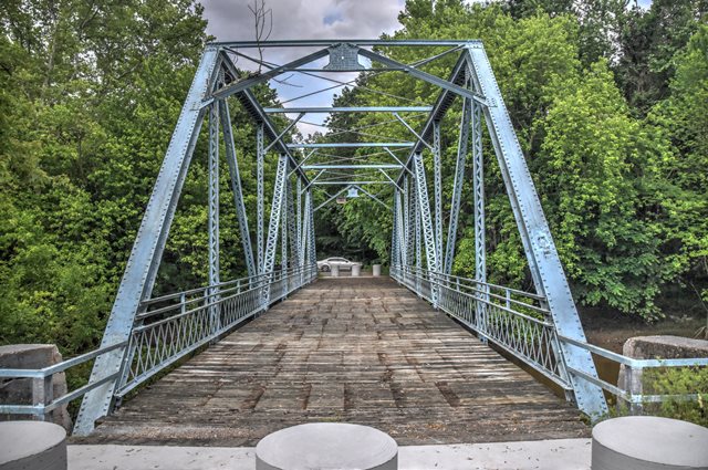
This riveted Warren highway through truss bridge has been bypassed and preserved for pedestrian use.
Information and Findings From DHPA Historic Bridge SurveyStatement of Significance For prior structure, see Gibson, "Severn (Cov.) Bridge". Designed by the Indiana Bridge Company of Muncie, Indiana, this all-riveted Warren through truss with verticals sits upon concrete abutments and wingwalls. Verticals, diagonals (except for center panels), and lower chord members all consist of a standard size of laced double angles. The diagonals which stretch outward from the top most central panel point consist of laced channels similar to those used for the top chord. Riveted to the gussets, I floor-beams carry the concrete deck with its 15'6" roadway and 14'6" of vertical clearance. One of the older Warrens known to have been fabricated by a prolific Indiana firm, this bridge is also one of the earliest all-riveted surviving throughs of its type. The design has been streamlined by using the same configuration of elements for the vertical, lower chord, and some diagonal members. The structure retains its original members, including its decoratively latticed guardrails. Severn's Bridge was closed in 1999, bypassed, and left in pedestrian use. References Lowell E. Morrison, Bridge Inspection Survey & Report of Gibson County (Princeton, 1974). United Consulting Engineers, Inc., Bridge Reinspection for Gibson County (Indianapolis, 1980, 1998). bridge nameplate. Indiana Bridge Co., Contract Index, #6563, Indiana Bridge Co. (Muncie). Indiana Historic Sites and Structures Inventory, Gibson and Warrick Counties: Interim Report (Indianapolis, 1984). Bridge Considered Historic By Survey: Yes |
![]()
![]()
![]()
Coordinates (Latitude, Longitude):
Search For Additional Bridge Listings:
Bridgehunter.com: View listed bridges within 0.5 miles (0.8 kilometers) of this bridge.
Bridgehunter.com: View listed bridges within 10 miles (16 kilometers) of this bridge.
Additional Maps:
Google Streetview (If Available)
GeoHack (Additional Links and Coordinates)
Apple Maps (Via DuckDuckGo Search)
Apple Maps (Apple devices only)
Android: Open Location In Your Map or GPS App
Flickr Gallery (Find Nearby Photos)
Wikimedia Commons (Find Nearby Photos)
Directions Via Sygic For Android
Directions Via Sygic For iOS and Android Dolphin Browser
USGS National Map (United States Only)
Historical USGS Topo Maps (United States Only)
Historic Aerials (United States Only)
CalTopo Maps (United States Only)

© Copyright 2003-2025, HistoricBridges.org. All Rights Reserved. Disclaimer: HistoricBridges.org is a volunteer group of private citizens. HistoricBridges.org is NOT a government agency, does not represent or work with any governmental agencies, nor is it in any way associated with any government agency or any non-profit organization. While we strive for accuracy in our factual content, HistoricBridges.org offers no guarantee of accuracy. Information is provided "as is" without warranty of any kind, either expressed or implied. Information could include technical inaccuracies or errors of omission. Opinions and commentary are the opinions of the respective HistoricBridges.org member who made them and do not necessarily represent the views of anyone else, including any outside photographers whose images may appear on the page in which the commentary appears. HistoricBridges.org does not bear any responsibility for any consequences resulting from the use of this or any other HistoricBridges.org information. Owners and users of bridges have the responsibility of correctly following all applicable laws, rules, and regulations, regardless of any HistoricBridges.org information.
![]()