We Recommend:
Bach Steel - Experts at historic truss bridge restoration.
BridgeHunter.com Phase 1 is released to the public! - Visit Now
Bentonsport Bridge

Primary Photographer(s): Nathan Holth and Rick McOmber
Bridge Documented: July 2, 2009
Bentonsport and Vernon: Van Buren County, Iowa: United States
1882 By Builder/Contractor: King Bridge Company of Cleveland, Ohio
1903
146.0 Feet (44.5 Meters)
730.0 Feet (222.5 Meters)
Not Available
5 Main Span(s)
Not Applicable

View Information About HSR Ratings
Bridge Documentation
There are several extremely rare and significant pin-connected truss bridges on the lower section of the Des Moines River. Each are distinguished as rare surviving examples of large, multi-span examples of their type. Among them, the Bentonsport Bridge stands out as a large, relatively complete, and early example. The bridge is a long, five-span truss bridge. Each span contains eight panels. One of the central spans was replaced after it was damaged in a flood in 1903. The span was replaced by the George E. King Bridge Company of Des Moines, Iowa, which was a spinoff of the King Bridge Company who built the original bridge.
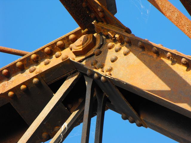
All spans on the bridge are traditionally composed, but the original spans do contain a few unusual details. Most noteworthy, a number of the pin bolts on the bridge are square bolts. Square bolts were common during the period this bridge was built, but not as pin bolts, where hexagonal bolts were far more common. There are also cast iron intersection assemblies for the diagonal member intersections with the counters, and also where the lateral bracing intersects. Finally, the original truss spans also contain fishtail style built-up floor beams.
The Bentonsport Bridge was also refitted to allow pedestrian usage. The preservation work was limited to the installation of a narrow deck with no work done to the bridge itself.. What was left of the former deck was allowed to remain in place. Original railings were left in place on the bridge, The structural condition of the bridge appears to be fair, and with its use being limited to non-motorized traffic, and the material of the bridge being corrosion-resistant wrought iron, the rate of deterioration on this bridge is low, even in its un-restored condition. There is interpretive signage posted for the bridge. However it is worth noting that although this 1882 bridge is the oldest intact bridge in Van Buren County, it is not the oldest Des Moines River Bridge as the sign claims, since the Eveland Bridge in Mahaska County was dated to 1877.
Most of the surviving Des Moines River pin-connected truss bridges in this region remain inaccessible due to flooding and deck damage. As such, the placement of a deck on the Bentonsport Bridge is significant because this makes the Bentonsport Bridges one of the few of these amazing Des Moines River bridges that can be more completely experienced. The bridge is a centerpiece that unifies the tiny communities of Vernon and Bentonsport, and the bridge provides a noteworthy attraction for two tiny communities that might otherwise pass unnoticed.
Information and Findings From Iowa's Historic Bridge InventoryDiscussion of Bridge Van Buren County built the Keosauqua Bridge, its
first major bridge over the Des Moines River, in 1873. Soon thereafter
other communities along the river began clamoring for bridges of their
own, prompting the county board of supervisors to pass a resolution in
January 1877 regarding bridge construction. Before the formation of the state highway commission, the individual counties of Iowa built wagon bridges themselves, typically contracting with bridge companies to design, fabricate and erect the all-metal spans. Numerous multiple-span bridges were built in this manner throughout Iowa in the late 19th century, many of the more spectacular examples spanning the Des Moines River in the southeast part of the state. Van Buren County eventually built eight large-scale bridges over the Des Moines River--at Selma, Douds, Keosauqua, Bentonsport, Bonaparte and Farmington. Although not the first such structures built, the Bentonsport Bridge is noteworthy as the oldest remaining intact bridge in the county. In well-preserved condition, the Bentonsport Bridge is an outstanding early wagon truss - one of the last multiple-span bridges from this formative period in Iowa transportation [adapted from Fraser 1991]. Bridge Considered Historic By Survey: Yes |
![]()
Photo Galleries and Videos: Bentonsport Bridge
Structure Overview
Original / Full Size PhotosA collection of overview photos that show the bridge as a whole and general areas of the bridge. This gallery offers photos in the highest available resolution and file size in a touch-friendly popup viewer.
Alternatively, Browse Without Using Viewer
![]()
Structure Details
Original / Full Size PhotosA collection of detail photos that document the parts, construction, and condition of the bridge. This gallery offers photos in the highest available resolution and file size in a touch-friendly popup viewer.
Alternatively, Browse Without Using Viewer
![]()
Structure Overview
Mobile Optimized PhotosA collection of overview photos that show the bridge as a whole and general areas of the bridge. This gallery features data-friendly, fast-loading photos in a touch-friendly popup viewer.
Alternatively, Browse Without Using Viewer
![]()
Structure Details
Mobile Optimized PhotosA collection of detail photos that document the parts, construction, and condition of the bridge. This gallery features data-friendly, fast-loading photos in a touch-friendly popup viewer.
Alternatively, Browse Without Using Viewer
![]()
Maps and Links: Bentonsport Bridge
Coordinates (Latitude, Longitude):
Search For Additional Bridge Listings:
Bridgehunter.com: View listed bridges within 0.5 miles (0.8 kilometers) of this bridge.
Bridgehunter.com: View listed bridges within 10 miles (16 kilometers) of this bridge.
Additional Maps:
Google Streetview (If Available)
GeoHack (Additional Links and Coordinates)
Apple Maps (Via DuckDuckGo Search)
Apple Maps (Apple devices only)
Android: Open Location In Your Map or GPS App
Flickr Gallery (Find Nearby Photos)
Wikimedia Commons (Find Nearby Photos)
Directions Via Sygic For Android
Directions Via Sygic For iOS and Android Dolphin Browser
USGS National Map (United States Only)
Historical USGS Topo Maps (United States Only)
Historic Aerials (United States Only)
CalTopo Maps (United States Only)


