We Recommend:
Bach Steel - Experts at historic truss bridge restoration.
BridgeHunter.com Phase 1 is released to the public! - Visit Now
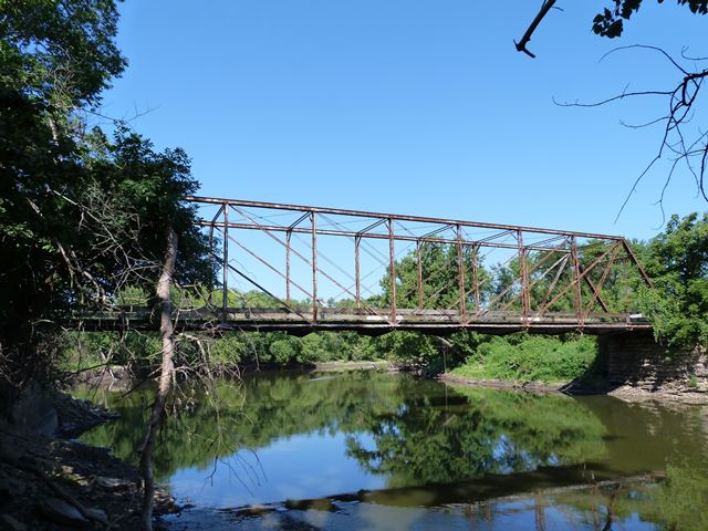
Quarry Bridge

Primary Photographer(s): Nathan Holth
Bridge Documented: August 10, 2013
Quarry: Marshall County, Iowa: United States
1885 By Builder/Contractor: King Bridge Company of Cleveland, Ohio
Not Available or Not Applicable
148.0 Feet (45.1 Meters)
150.0 Feet (45.7 Meters)
16 Feet (4.88 Meters)
1 Main Span(s)
242320

View Information About HSR Ratings
Bridge Documentation
View Archived National Bridge Inventory Report - Has Additional Details and Evaluation
This bridge is an old and rare example of a Whipple truss bridge. It is further significant as a bridge built by the prolific and noteworthy King Bridge Company. The actual on-site construction was undertaken by King and Twiss of Des Moines, Iowa. The bridge has been closed to traffic, but is in decent condition. It would be easy to restore for pedestrian use either here or relocated to a new location. It also would be feasible to rehabilitate for light vehicular use. Either way, this bridge deserves to be preserved. It retains good historic integrity although some alterations were noted included a repaired vertical and diagonal member. Some of the diagonal member intersection castings have broken off.
Apparently, there is a park called Three Bridges Park immediately northeast of this bridge. Restoring this bridge for pedestrian use as part of this park is an idea to consider.
Information and Findings From Iowa's Historic Bridge InventoryDiscussion of Bridge The bridge over the Iowa River near the town of Quarry in Le Grand Township was one of Marshall County's oldest spans when it collapsed during late spring flooding in 1885. In June the board of supervisors hired
the Wright Brothers, local contractors, to pull the wrecked structure from the river, and subsequently solicited competitive proposals from bridge companies for a replacement span. On July 1st the board awarded a construction
contract to low-bidder King and Twiss of Des Moines for a 150-foot Whipple truss identical to the Stanley Mill Bridge, built by the county the year before. Using a superstructure fabricated by the King Iron Bridge Company of
Cleveland, Ohio, the builders completed the bridge by September at a total cost of $3,295. The Quarry Bridge has carried traffic since, with the reconstruction of its north abutment with concrete the only major alteration of note. Bridge Considered Historic By Survey: Yes |
![]()
Photo Galleries and Videos: Quarry Bridge
Bridge Photo-Documentation
Original / Full Size PhotosA collection of overview and detail photos. This gallery offers photos in the highest available resolution and file size in a touch-friendly popup viewer.
Alternatively, Browse Without Using Viewer
![]()
Bridge Photo-Documentation
Mobile Optimized PhotosA collection of overview and detail photos. This gallery features data-friendly, fast-loading photos in a touch-friendly popup viewer.
Alternatively, Browse Without Using Viewer
![]()
Maps and Links: Quarry Bridge
Coordinates (Latitude, Longitude):
Search For Additional Bridge Listings:
Bridgehunter.com: View listed bridges within 0.5 miles (0.8 kilometers) of this bridge.
Bridgehunter.com: View listed bridges within 10 miles (16 kilometers) of this bridge.
Additional Maps:
Google Streetview (If Available)
GeoHack (Additional Links and Coordinates)
Apple Maps (Via DuckDuckGo Search)
Apple Maps (Apple devices only)
Android: Open Location In Your Map or GPS App
Flickr Gallery (Find Nearby Photos)
Wikimedia Commons (Find Nearby Photos)
Directions Via Sygic For Android
Directions Via Sygic For iOS and Android Dolphin Browser
USGS National Map (United States Only)
Historical USGS Topo Maps (United States Only)
Historic Aerials (United States Only)
CalTopo Maps (United States Only)

