

View Information About HSR Ratings
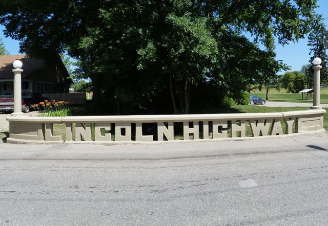
This bridge is structurally a very short and simple reinforced concrete slab bridge. However, it was built with a lot of ornamentation, all aimed at advertising the Lincoln Highway which it was built to carry. As such, the bridge has a unique railing that is composed of letters spelling out "Lincoln Highway." It also has lighting standards at each corner. The bridge is historically significant for its association with the development and promotion of the Lincoln Highway. It is an intact and unaltered part of this highway which was the first successful highway route that ran from coast to coast in the United States.
Information and Findings From Iowa's Historic Bridge InventoryDiscussion of Bridge On May 17, 1915, the Tama County Board of Supervisors contracted with Paul N. Kingsley, a relatively new contractor from Strawberry Point, Iowa, to build 53 bridges and culverts throughout the county. Kingsley was to complete the work by November 1st of that year, for $39,900. But by November Kingsley, who was struggling to manage the ambitious, multiple-bridge contracts he then held with several Iowa counties, had completed only a minimal amount of work. Although the board considered taking action against Kingsley and his bonding company in meetings held on November 27th and 30th, on December 28th they extended his contract to July 1, 1916. By spring, though, it was evident that Kingsley no longer had the wherewithal to complete the work. The supervisors declared Kingsley in default of the contract, and in December 1916, settled with the bonding company and contracted with other firms for his unfinished work. Kingsley's difficulties in fulfilling his obligations are not revealed in the historic record, and his name quickly passed from county bridge building circles. Yet Kingsley did leave a lasting legacy by building the Lincoln Highway Bridge in Tama. Constructed in 1915, three years after the formation of the Lincoln Highway Association, the bridge is representative of efforts by local officials in order to promote automobile travel to encourage economic development. In recent years, following a relocation of U.S. Highway 30, the bridge has served to carry local traffic. Although for contractor Paul Kingsley the Lincoln Highway Bridge represented the beginning of the end, for the town of Tama it commemorated the town's place on the nation's first transcontinental highway, with the traffic commerce that accompanied it. When the route was first plotted in 1913, the citizens of Tama and the surrounding area immediately recognized its importance. "We can scarcely estimate the travel this national road will induce," the Traer Star-Clipper stated in November 1913. "Millions have already been pledged toward it and every state it spans is at work planning construction. All along the 3,000 miles work is in progress. This will probably become the best long distance auto road in the United States. Fortunate indeed is Tama county to have it pass through her entire length." The highway was routed through the small town of Tama, along Fifth Street at the town's eastern edge. When in 1915 the county planned a small bridge to carry the Lincoln Highway over Mud Creek in Tama, the county supervisors opted to add architectural expression to the otherwise typical concrete slab structure, as a means to distinguish the bridge from the hundreds of others [adapted from Fraser 1990] Bridge Considered Historic By Survey: Yes |
![]()
![]()
![]()
Coordinates (Latitude, Longitude):
Search For Additional Bridge Listings:
Bridgehunter.com: View listed bridges within 0.5 miles (0.8 kilometers) of this bridge.
Bridgehunter.com: View listed bridges within 10 miles (16 kilometers) of this bridge.
Additional Maps:
Google Streetview (If Available)
GeoHack (Additional Links and Coordinates)
Apple Maps (Via DuckDuckGo Search)
Apple Maps (Apple devices only)
Android: Open Location In Your Map or GPS App
Flickr Gallery (Find Nearby Photos)
Wikimedia Commons (Find Nearby Photos)
Directions Via Sygic For Android
Directions Via Sygic For iOS and Android Dolphin Browser
USGS National Map (United States Only)
Historical USGS Topo Maps (United States Only)
Historic Aerials (United States Only)
CalTopo Maps (United States Only)

© Copyright 2003-2026, HistoricBridges.org. All Rights Reserved. Disclaimer: HistoricBridges.org is a volunteer group of private citizens. HistoricBridges.org is NOT a government agency, does not represent or work with any governmental agencies, nor is it in any way associated with any government agency or any non-profit organization. While we strive for accuracy in our factual content, HistoricBridges.org offers no guarantee of accuracy. Information is provided "as is" without warranty of any kind, either expressed or implied. Information could include technical inaccuracies or errors of omission. Opinions and commentary are the opinions of the respective HistoricBridges.org member who made them and do not necessarily represent the views of anyone else, including any outside photographers whose images may appear on the page in which the commentary appears. HistoricBridges.org does not bear any responsibility for any consequences resulting from the use of this or any other HistoricBridges.org information. Owners and users of bridges have the responsibility of correctly following all applicable laws, rules, and regulations, regardless of any HistoricBridges.org information.
![]()