

View Information About HSR Ratings
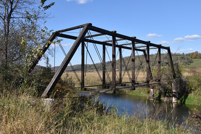
Abandoned and deteriorating, this is an exceedingly rare example of a combination truss, using both timber and metal in its construction. Built in 1920, it is a bit of an anomaly, as most combination bridges were built in the 19th century as builders and engineers experimented with and transitioned to using metal in bridge construction instead of timber. Reglardless of its late construction date, its traditional pin-connected construction still accurately documents what a timber/metal combination truss looks like.
Information and Findings From Iowa's Historic Bridge InventoryDiscussion of Bridge Now abandoned with its stringers and deck removed,
the Red Bridge spans the Yellow River northeast of Postville, in
Franklin Township. The structure dates to 1920. That year the Allamakee
County Engineer designed this 98-foot timber truss--the first bridge at
this crossing--estimated its cost at $2,500, and let a series of private
contracts for its fabrication and erection. The Worden-Allen Company of
Milwaukee provided the structural steel, City Lumber provided the
timbers, a man named Ryerson provided the hardware, and local contractor
A.L. Powell built the truss. Total cost of the bridge was $2,304.74.
Called the Red Bridge, the Yellow River Bridge or Oelberg Bridge
locally, this timber truss featured a Pratt configuration, with timber
compression members and forged iron tension members. The upper-chord
timbers are bolted to the timber verticals using iron plates; the iron
eye-rod lower chords are pinned to the verticals. From these pins the
floor beams are hung using U-bolts. The Red Bridge carried traffic until
its later closure (at an unknown date). The timber deck and stringers
were subsequently removed, and the bridge now stands abandoned in
deteriorating condition. Bridge Considered Historic By Survey: Yes |
![]()
![]()
![]()
Coordinates (Latitude, Longitude):
Search For Additional Bridge Listings:
Bridgehunter.com: View listed bridges within 0.5 miles (0.8 kilometers) of this bridge.
Bridgehunter.com: View listed bridges within 10 miles (16 kilometers) of this bridge.
Additional Maps:
Google Streetview (If Available)
GeoHack (Additional Links and Coordinates)
Apple Maps (Via DuckDuckGo Search)
Apple Maps (Apple devices only)
Android: Open Location In Your Map or GPS App
Flickr Gallery (Find Nearby Photos)
Wikimedia Commons (Find Nearby Photos)
Directions Via Sygic For Android
Directions Via Sygic For iOS and Android Dolphin Browser
USGS National Map (United States Only)
Historical USGS Topo Maps (United States Only)
Historic Aerials (United States Only)
CalTopo Maps (United States Only)

© Copyright 2003-2025, HistoricBridges.org. All Rights Reserved. Disclaimer: HistoricBridges.org is a volunteer group of private citizens. HistoricBridges.org is NOT a government agency, does not represent or work with any governmental agencies, nor is it in any way associated with any government agency or any non-profit organization. While we strive for accuracy in our factual content, HistoricBridges.org offers no guarantee of accuracy. Information is provided "as is" without warranty of any kind, either expressed or implied. Information could include technical inaccuracies or errors of omission. Opinions and commentary are the opinions of the respective HistoricBridges.org member who made them and do not necessarily represent the views of anyone else, including any outside photographers whose images may appear on the page in which the commentary appears. HistoricBridges.org does not bear any responsibility for any consequences resulting from the use of this or any other HistoricBridges.org information. Owners and users of bridges have the responsibility of correctly following all applicable laws, rules, and regulations, regardless of any HistoricBridges.org information.
![]()