

View Information About HSR Ratings
This bridge is abandoned with deck and deck stringers removed.
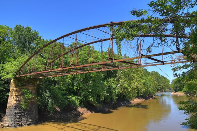
Cast and wrought iron bowstring truss bridges represent some of the earliest, rarest, and most significant historic bridges in the country. And among bowstring bridges, this is one of the most significant examples. Firstly, its main span is one of the few surviving bowstrings by the Wrought Iron Bridge Company that uses genuine Phoenix columns for the upper chord. The company typically used Keystone columns (or columns resembling Keystone columns), and appears to have rarely used Phoenix columns. Not only does the upper chord have the appearance of a Phoenix column, it bears the name of Phoenix Iron to prove that they were actually rolled in by the Phoenixville, Pennsylvania based company.
This bridge also has a pony truss bowstring approach span, with an estimated span length of 75 feet. Unlike the main span, this one does use the more common Keystone-style column. As such this bridge offers a unique comparison to the two columns... at least in the winter. In the summer, the overgrowth is so extensive that the pony truss is literally not visible from the south side, which is the easily accessible end.
This bridge is tagged with the following special condition(s): Phoenix Columns
![]()
![]()
![]()
Reportedly, this abandoned bridge is still in public right-of-way, despite no trespassing signs posted.
Coordinates (Latitude, Longitude):
Search For Additional Bridge Listings:
Bridgehunter.com: View listed bridges within 0.5 miles (0.8 kilometers) of this bridge.
Bridgehunter.com: View listed bridges within 10 miles (16 kilometers) of this bridge.
Additional Maps:
Google Streetview (If Available)
GeoHack (Additional Links and Coordinates)
Apple Maps (Via DuckDuckGo Search)
Apple Maps (Apple devices only)
Android: Open Location In Your Map or GPS App
Flickr Gallery (Find Nearby Photos)
Wikimedia Commons (Find Nearby Photos)
Directions Via Sygic For Android
Directions Via Sygic For iOS and Android Dolphin Browser
USGS National Map (United States Only)
Historical USGS Topo Maps (United States Only)
Historic Aerials (United States Only)
CalTopo Maps (United States Only)

© Copyright 2003-2026, HistoricBridges.org. All Rights Reserved. Disclaimer: HistoricBridges.org is a volunteer group of private citizens. HistoricBridges.org is NOT a government agency, does not represent or work with any governmental agencies, nor is it in any way associated with any government agency or any non-profit organization. While we strive for accuracy in our factual content, HistoricBridges.org offers no guarantee of accuracy. Information is provided "as is" without warranty of any kind, either expressed or implied. Information could include technical inaccuracies or errors of omission. Opinions and commentary are the opinions of the respective HistoricBridges.org member who made them and do not necessarily represent the views of anyone else, including any outside photographers whose images may appear on the page in which the commentary appears. HistoricBridges.org does not bear any responsibility for any consequences resulting from the use of this or any other HistoricBridges.org information. Owners and users of bridges have the responsibility of correctly following all applicable laws, rules, and regulations, regardless of any HistoricBridges.org information.
![]()