

View Information About HSR Ratings
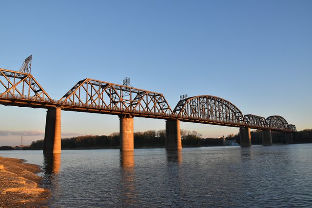
Featuring former vehicular decks cantilevered from the sides of the trusses with a railroad deck in the middle, this bridge is also noted for its variety of truss designs. Because of this variety, this bridge is hard to classify into main and approach spans. Typically HistoricBridges.org considers the movable span of a bridge to be the main span. However, the estimated 625 foot fixed Pennsylvania truss spans of this bridge are both visually dominating and technologically noteworthy for their extremely long span length, and therefore have been listed as the main spans here. However, the 400 foot swing span is large in its own right. It is a bit comical looking because its height above the river is so great that it may be somewhat unexpected to see a movable span at all. Adding to the novelty in the present day is that this swing span (which no longer is needed to open for boats) doesn't even line up with the lock system that is on the Ohio River at this location to accommodate the elevation change associated with the Falls of the Ohio. Reportedly, the swing span was intended to be used during periods of high water levels, and was never meant to operate for typical boats and river conditions.
The cantilevered vehicular decks of this bridge have been abandoned, and the bridge serves railroad traffic only today. However, the vehicular decks remain in place (as of 2016) and thus the bridge retains the historic integrity associated with the vehicular function this bridge once served.
The consulting engineers listed for this bridge are Jason M. Johnson and John E. Greiner. Of these two, Greiner is more well-known, as he went on to form his own engineering practice and designed many large bridges.
Foster-Creighton-Gould Company of Nashville, Tennessee built the bridge substructure, and the American Bridge Company of New York, New York built the superstructure.
![]()
![]()
![]()
Coordinates (Latitude, Longitude):
Search For Additional Bridge Listings:
Bridgehunter.com: View listed bridges within 0.5 miles (0.8 kilometers) of this bridge.
Bridgehunter.com: View listed bridges within 10 miles (16 kilometers) of this bridge.
Additional Maps:
Google Streetview (If Available)
GeoHack (Additional Links and Coordinates)
Apple Maps (Via DuckDuckGo Search)
Apple Maps (Apple devices only)
Android: Open Location In Your Map or GPS App
Flickr Gallery (Find Nearby Photos)
Wikimedia Commons (Find Nearby Photos)
Directions Via Sygic For Android
Directions Via Sygic For iOS and Android Dolphin Browser
USGS National Map (United States Only)
Historical USGS Topo Maps (United States Only)
Historic Aerials (United States Only)
CalTopo Maps (United States Only)

© Copyright 2003-2026, HistoricBridges.org. All Rights Reserved. Disclaimer: HistoricBridges.org is a volunteer group of private citizens. HistoricBridges.org is NOT a government agency, does not represent or work with any governmental agencies, nor is it in any way associated with any government agency or any non-profit organization. While we strive for accuracy in our factual content, HistoricBridges.org offers no guarantee of accuracy. Information is provided "as is" without warranty of any kind, either expressed or implied. Information could include technical inaccuracies or errors of omission. Opinions and commentary are the opinions of the respective HistoricBridges.org member who made them and do not necessarily represent the views of anyone else, including any outside photographers whose images may appear on the page in which the commentary appears. HistoricBridges.org does not bear any responsibility for any consequences resulting from the use of this or any other HistoricBridges.org information. Owners and users of bridges have the responsibility of correctly following all applicable laws, rules, and regulations, regardless of any HistoricBridges.org information.
![]()