

View Information About HSR Ratings
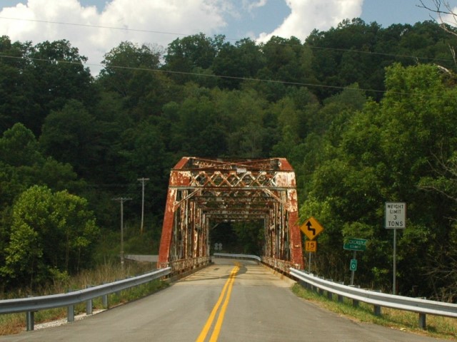
This bridge is an excellent example of a 1920s riveted truss bridge in Kentucky, and its Pennsylvania truss configuration is uncommon. By 2007, the bridge had developed some deterioration that led to a very low 3 ton weight limit and a low 2% sufficiency rating. Those familiar with historic truss bridge should know that those issues do not always mean that it is not possible and economical to rehabilitate the bridge, but at the same time these numbers are often interpreted by the owner as meaning the bridge must be replaced, especially in a state like Kentucky which has a low rate of preservation. However, news articles reported that rehabilitation has been in fact planned for this bridge. If true, this bridge would be a great success story for Kentucky where so few bridges of this type have been preserved.
The plaque for this bridge has broken off in several areas, so the builder name is mostly missing. However it appears that the builder may have been the Brookville Bridge Company based on the text remaining.
![]()
![]()
![]()
Coordinates (Latitude, Longitude):
Search For Additional Bridge Listings:
Bridgehunter.com: View listed bridges within 0.5 miles (0.8 kilometers) of this bridge.
Bridgehunter.com: View listed bridges within 10 miles (16 kilometers) of this bridge.
Additional Maps:
Google Streetview (If Available)
GeoHack (Additional Links and Coordinates)
Apple Maps (Via DuckDuckGo Search)
Apple Maps (Apple devices only)
Android: Open Location In Your Map or GPS App
Flickr Gallery (Find Nearby Photos)
Wikimedia Commons (Find Nearby Photos)
Directions Via Sygic For Android
Directions Via Sygic For iOS and Android Dolphin Browser
USGS National Map (United States Only)
Historical USGS Topo Maps (United States Only)
Historic Aerials (United States Only)
CalTopo Maps (United States Only)

© Copyright 2003-2026, HistoricBridges.org. All Rights Reserved. Disclaimer: HistoricBridges.org is a volunteer group of private citizens. HistoricBridges.org is NOT a government agency, does not represent or work with any governmental agencies, nor is it in any way associated with any government agency or any non-profit organization. While we strive for accuracy in our factual content, HistoricBridges.org offers no guarantee of accuracy. Information is provided "as is" without warranty of any kind, either expressed or implied. Information could include technical inaccuracies or errors of omission. Opinions and commentary are the opinions of the respective HistoricBridges.org member who made them and do not necessarily represent the views of anyone else, including any outside photographers whose images may appear on the page in which the commentary appears. HistoricBridges.org does not bear any responsibility for any consequences resulting from the use of this or any other HistoricBridges.org information. Owners and users of bridges have the responsibility of correctly following all applicable laws, rules, and regulations, regardless of any HistoricBridges.org information.
![]()