HistoricBridges.org Menu: HistoricBridges.org Menu:


We Recommend:
Bach Steel - Experts at historic truss bridge restoration.

HistoricBridges.org: Bridge Browser

Owensboro Bridge

Glover Cary Bridge

Owensboro Bridge

Primary Photographer(s): Nathan Holth

Bridge Documented: May 27, 2019

View Photos
and Videos
View Maps
and Links

Facility Carried / Feature Intersected
IN-161 (Old US-231) Over Ohio River, 2nd Street, and CR-710 South
Location
Owensboro: Daviess County, Kentucky and Spencer County, Indiana: United States
Structure Type
Metal Cantilever 17 Panel Rivet-Connected Warren Through Truss, Fixed and Approach Spans: Metal 10 Panel Rivet-Connected Warren Deck Truss, Fixed
Construction Date and Builder / Engineer
1940 By Builder/Contractor: Hunter Steel Company of Pittsburgh, Pennsylvania and Engineer/Design: Modjeski and Masters
Rehabilitation Date
Not Available or Not Applicable
Main Span Length
750.8 Feet (228.8 Meters)
Structure Length
4,623.0 Feet (1409.1 Meters)
Roadway Width
22 Feet (6.71 Meters)
Spans
4 Main Span(s) and 33 Approach Span(s)
Inventory Number
030B00118N

Historic Significance Rating (HSR)
View Information About HSR Ratings

Bridge Documentation

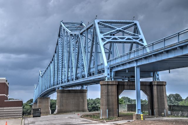
This increasingly rare cantilever truss bridge is noted for its beauty, span configuration, and lack of alteration.

View Archived National Bridge Inventory Report - Has Additional Details and Evaluation

View Historical Articles About This Bridge

Above: Original drawings of bridge.

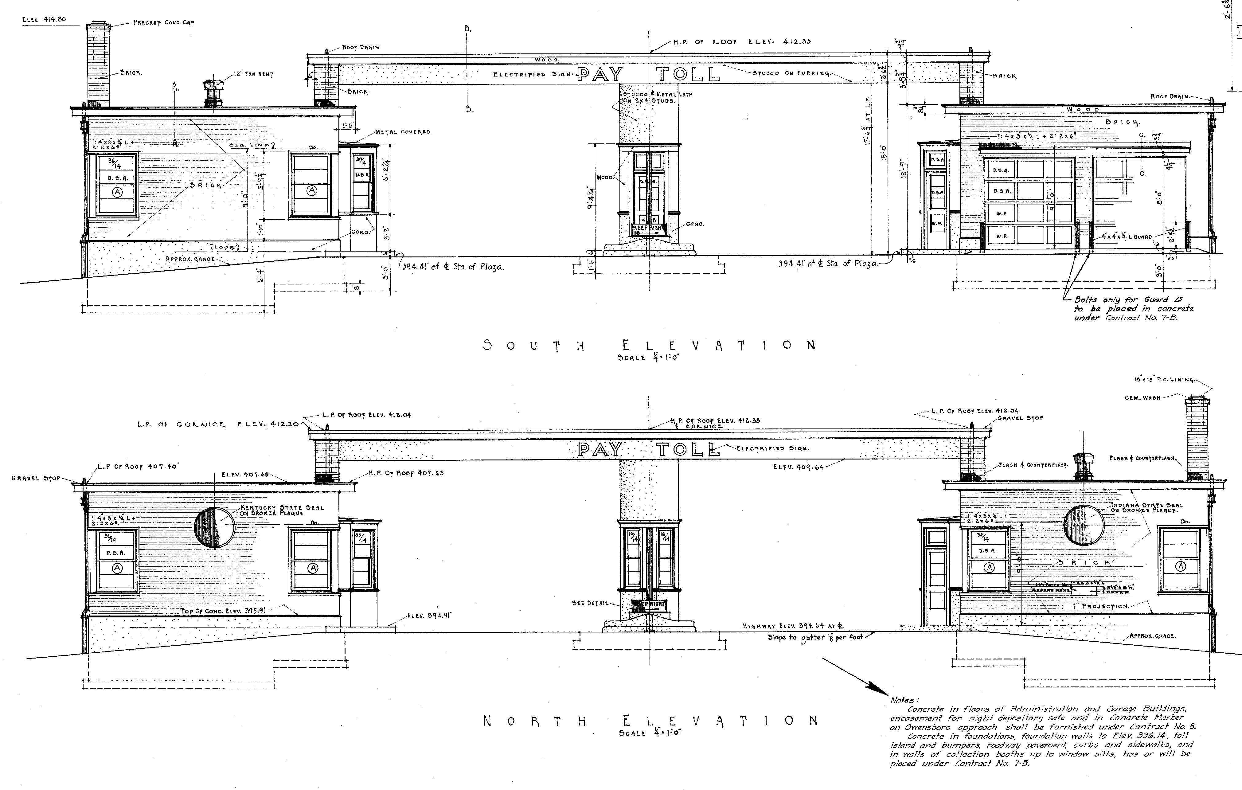
Above: Original drawing for the toll plaza that was originally at the Indiana end of the bridge.

Divider

Photo Galleries and Videos: Owensboro Bridge


View Photo Gallery

Structure Overview

Original / Full Size Photos
A collection of overview photos that show the bridge as a whole and general areas of the bridge. This gallery offers photos in the highest available resolution and file size in a touch-friendly popup viewer.
Alternatively, Browse Without Using Viewer

Divider

View Photo Gallery

Structure Details

Original / Full Size Photos
A collection of detail photos that document the parts, construction, and condition of the bridge. This gallery offers photos in the highest available resolution and file size in a touch-friendly popup viewer.
Alternatively, Browse Without Using Viewer

Divider

View Photo Gallery

Structure Overview

Mobile Optimized Photos
A collection of overview photos that show the bridge as a whole and general areas of the bridge. This gallery features data-friendly, fast-loading photos in a touch-friendly popup viewer.
Alternatively, Browse Without Using Viewer

Divider

View Photo Gallery

Structure Details

Mobile Optimized Photos
A collection of detail photos that document the parts, construction, and condition of the bridge. This gallery features data-friendly, fast-loading photos in a touch-friendly popup viewer.
Alternatively, Browse Without Using Viewer

Divider

Maps and Links: Owensboro Bridge

Coordinates (Latitude, Longitude):

Search For Additional Bridge Listings:

Bridgehunter.com: View listed bridges within 0.5 miles (0.8 kilometers) of this bridge.

Bridgehunter.com: View listed bridges within 10 miles (16 kilometers) of this bridge.

HistoricBridges.org Bridge Browser: View listed bridges within 0.5 miles (0.8 kilometers) of this bridge.

HistoricBridges.org Bridge Browser: View listed bridges within 10 miles (16 kilometers) of this bridge.

2021 National Bridge Inventory: View listed bridges within 0.5 miles (0.8 kilometers) of this bridge.

Additional Maps:

Google Maps

Google Streetview (If Available)

Bing Maps

OpenStreetMap

GeoHack (Additional Links and Coordinates)

Apple Maps (Via DuckDuckGo Search)

Apple Maps (Apple devices only)

MapQuest

HERE We Go Maps

ACME Mapper

Waze Map

Android: Open Location In Your Map or GPS App

Flickr Gallery (Find Nearby Photos)

Wikimedia Commons (Find Nearby Photos)

Directions Via Sygic For Android

Directions Via Sygic For iOS and Android Dolphin Browser

USGS National Map (United States Only)

Historical USGS Topo Maps (United States Only)

Historic Aerials (United States Only)

CalTopo Maps (United States Only)


Divider
 
Home Top

Divider

About - Contact

© Copyright 2003-2024, HistoricBridges.org. All Rights Reserved. Disclaimer: HistoricBridges.org is a volunteer group of private citizens. HistoricBridges.org is NOT a government agency, does not represent or work with any governmental agencies, nor is it in any way associated with any government agency or any non-profit organization. While we strive for accuracy in our factual content, HistoricBridges.org offers no guarantee of accuracy. Information is provided "as is" without warranty of any kind, either expressed or implied. Information could include technical inaccuracies or errors of omission. Opinions and commentary are the opinions of the respective HistoricBridges.org member who made them and do not necessarily represent the views of anyone else, including any outside photographers whose images may appear on the page in which the commentary appears. HistoricBridges.org does not bear any responsibility for any consequences resulting from the use of this or any other HistoricBridges.org information. Owners and users of bridges have the responsibility of correctly following all applicable laws, rules, and regulations, regardless of any HistoricBridges.org information.

Admin Login

Divider