We Recommend:
Bach Steel - Experts at historic truss bridge restoration.
BridgeHunter.com Phase 1 is released to the public! - Visit Now
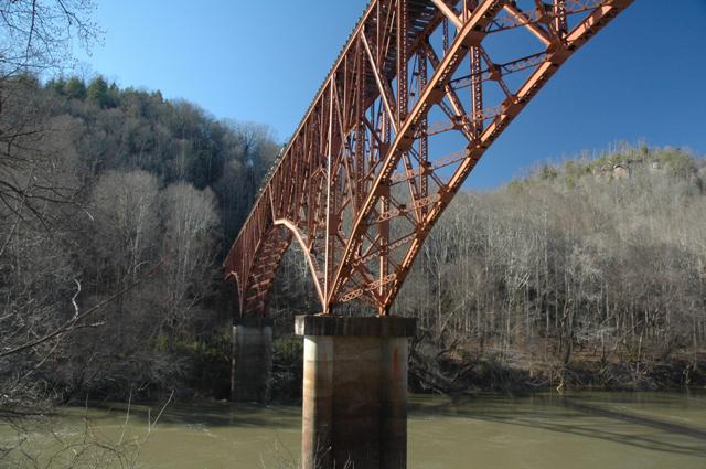
Blue Heron Railroad Bridge

Primary Photographer(s): Dave Michaels
Bridge Documented: January 8, 2007
Blue Heron (Rural): McCreary County, Kentucky: United States
Metal Cantilever Rivet-Connected Baltimore Deck Truss, Fixed and Approach Spans: Metal Deck Girder, Fixed
By Builder/Contractor: Unknown
Not Available or Not Applicable
Not Available
Not Available
Not Available
3 Main Span(s)
Not Applicable

View Information About HSR Ratings
Bridge Documentation
Cantilever deck truss bridges like this one are often mistaken for arch bridges. However, due to an unusual feature with this bridge, few will make that mistake here. The bottom chord of this bridge turns into an end-post of sorts and meets the deck at mid-span. This gives the bridge a rather unusual appearance. If it were an arch bridge it would not stand like this, and would collapse, since with arch bridges, the arch needs to run continuous and support needed most in the center. With a cantilever bridge however, the strength starts at the support and goes out, like the limbs on a tree. Therefore, each half of this bridge could stand independently of each other and still support weight. For this reason, there really was no need for support at the center of this bridge, so engineers brought the bottom chord back up to the deck.
This bridge is significant as an uncommon example of a cantilever deck truss that dates to the late 1930s, although the exact date is unknown. It was built to access a mine, and was used until the 1960s. It features riveted connections, and built-up members and chords that include attractive lattice and v-lacing. it is located in the Big South Fork National River and Recreation Area. The bridge is hard to photograph even in the winter, plus to make matters worse, signs mounted on the trails warn people of dangerous snakes.
![]()
Photo Galleries and Videos: Blue Heron Railroad Bridge
Bridge Photo-Documentation
A collection of overview and detail photos. This photo gallery contains a combination of Original Size photos and Mobile Optimized photos in a touch-friendly popup viewer.Alternatively, Browse Without Using Viewer
![]()
Maps and Links: Blue Heron Railroad Bridge
Coordinates (Latitude, Longitude):
Search For Additional Bridge Listings:
Bridgehunter.com: View listed bridges within 0.5 miles (0.8 kilometers) of this bridge.
Bridgehunter.com: View listed bridges within 10 miles (16 kilometers) of this bridge.
Additional Maps:
Google Streetview (If Available)
GeoHack (Additional Links and Coordinates)
Apple Maps (Via DuckDuckGo Search)
Apple Maps (Apple devices only)
Android: Open Location In Your Map or GPS App
Flickr Gallery (Find Nearby Photos)
Wikimedia Commons (Find Nearby Photos)
Directions Via Sygic For Android
Directions Via Sygic For iOS and Android Dolphin Browser
USGS National Map (United States Only)
Historical USGS Topo Maps (United States Only)
Historic Aerials (United States Only)
CalTopo Maps (United States Only)

