

View Information About HSR Ratings
While the bridge seen today lacks historic significance, it is a rather interesting story in addressing the ever-increasing traffic needs of busy I-75. The timeline of the bridge is as follows:
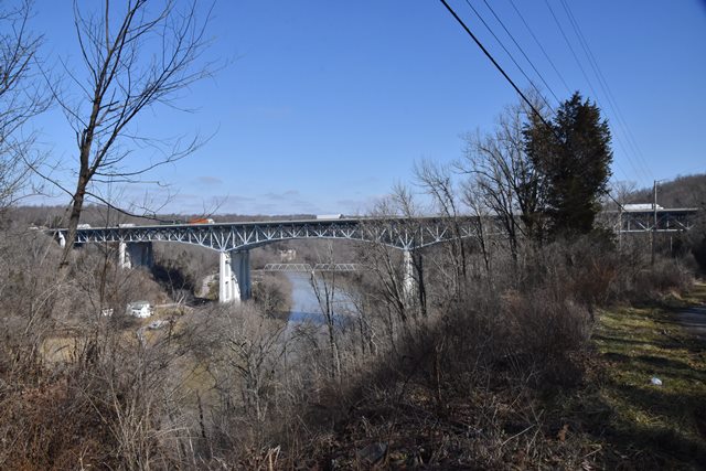
1946: A new deck truss bridge is completed by Mt. Vernon Bridge Co. of Mt. Vernon, Ohio to serve US-25. This bridge features concrete piers with gothic arches.
1963: A companion bridge, reportedly of similar design, is built next to the existing bridge to convert the bridge to serve the new interstate highway, I-75. This bridge features concrete piers with more simple appearance, and simple rectangular openings inside.
1998: A third pier of solid design and simple appearance is added in between the two piers of the bridges, and at this time both truss superstructures were demolished and replaced with a single new superstructure, a deck truss with four truss lines, effectively turning what was once two bridges with two lanes each into a single six lane bridge. These trusses follow the same Warren truss configuration as previous bridges, but lacking any rivets or built-up beams.
Anyone unfamiliar with this story would likely wonder why the piers under the bridge look so weird!
.

Above: Postcard showing original bridge.
This bridge is tagged with the following special condition(s): Unorganized Photos
![]()
![]()
![]()
Coordinates (Latitude, Longitude):
Search For Additional Bridge Listings:
Bridgehunter.com: View listed bridges within 0.5 miles (0.8 kilometers) of this bridge.
Bridgehunter.com: View listed bridges within 10 miles (16 kilometers) of this bridge.
Additional Maps:
Google Streetview (If Available)
GeoHack (Additional Links and Coordinates)
Apple Maps (Via DuckDuckGo Search)
Apple Maps (Apple devices only)
Android: Open Location In Your Map or GPS App
Flickr Gallery (Find Nearby Photos)
Wikimedia Commons (Find Nearby Photos)
Directions Via Sygic For Android
Directions Via Sygic For iOS and Android Dolphin Browser
USGS National Map (United States Only)
Historical USGS Topo Maps (United States Only)
Historic Aerials (United States Only)
CalTopo Maps (United States Only)

© Copyright 2003-2025, HistoricBridges.org. All Rights Reserved. Disclaimer: HistoricBridges.org is a volunteer group of private citizens. HistoricBridges.org is NOT a government agency, does not represent or work with any governmental agencies, nor is it in any way associated with any government agency or any non-profit organization. While we strive for accuracy in our factual content, HistoricBridges.org offers no guarantee of accuracy. Information is provided "as is" without warranty of any kind, either expressed or implied. Information could include technical inaccuracies or errors of omission. Opinions and commentary are the opinions of the respective HistoricBridges.org member who made them and do not necessarily represent the views of anyone else, including any outside photographers whose images may appear on the page in which the commentary appears. HistoricBridges.org does not bear any responsibility for any consequences resulting from the use of this or any other HistoricBridges.org information. Owners and users of bridges have the responsibility of correctly following all applicable laws, rules, and regulations, regardless of any HistoricBridges.org information.
![]()