

View Information About HSR Ratings
This is the second historic bridge moved and preserved at Sandy Watkins Park. The previous location was over Blackford Creek on Toler Bridge Road between Hancock County, Kentucky, and Daviess County, Kentucky. Please see the BridgeHunter page for photos of the bridge in this previous location and a photo of the plaque which has gone missing sadly.
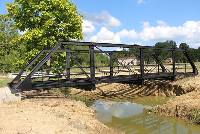
This bridge is overall a traditional half-hip pony truss bridge with pinned connections, however it has an extremely unusual design of built-up vertical members, making this a distinctive bridge with an unusual design detail. This adds to the signficance of the bridge. Newspapers covering the relocation listed the construction date for this bridge as 1919 and the National Bridge Inventory listed a 1920 date. However pinned connections were not being used on pony truss bridges at this time, nor were unusual designs of built-up members. The bridge looks more like a ca. 1890s bridge. It is possible the 1919 date refers to a major rehabilitation or another relocation of the bridge back in 1919. The narrow 11.5 foot roadway width of the bridge is also suggestive of an older bridge. In 1919, even a 15 foot roadway would have been fairly narrow.
The photos appearing on this page were taken after the bridge had been moved, but before the deck was installed.
This bridge is tagged with the following special condition(s): Unorganized Photos
![]()
![]()
![]()
Coordinates (Latitude, Longitude):
Search For Additional Bridge Listings:
Bridgehunter.com: View listed bridges within 0.5 miles (0.8 kilometers) of this bridge.
Bridgehunter.com: View listed bridges within 10 miles (16 kilometers) of this bridge.
Additional Maps:
Google Streetview (If Available)
GeoHack (Additional Links and Coordinates)
Apple Maps (Via DuckDuckGo Search)
Apple Maps (Apple devices only)
Android: Open Location In Your Map or GPS App
Flickr Gallery (Find Nearby Photos)
Wikimedia Commons (Find Nearby Photos)
Directions Via Sygic For Android
Directions Via Sygic For iOS and Android Dolphin Browser
USGS National Map (United States Only)
Historical USGS Topo Maps (United States Only)
Historic Aerials (United States Only)
CalTopo Maps (United States Only)

© Copyright 2003-2025, HistoricBridges.org. All Rights Reserved. Disclaimer: HistoricBridges.org is a volunteer group of private citizens. HistoricBridges.org is NOT a government agency, does not represent or work with any governmental agencies, nor is it in any way associated with any government agency or any non-profit organization. While we strive for accuracy in our factual content, HistoricBridges.org offers no guarantee of accuracy. Information is provided "as is" without warranty of any kind, either expressed or implied. Information could include technical inaccuracies or errors of omission. Opinions and commentary are the opinions of the respective HistoricBridges.org member who made them and do not necessarily represent the views of anyone else, including any outside photographers whose images may appear on the page in which the commentary appears. HistoricBridges.org does not bear any responsibility for any consequences resulting from the use of this or any other HistoricBridges.org information. Owners and users of bridges have the responsibility of correctly following all applicable laws, rules, and regulations, regardless of any HistoricBridges.org information.
![]()