We Recommend:
Bach Steel - Experts at historic truss bridge restoration.
BridgeHunter.com Phase 1 is released to the public! - Visit Now
Butte Larose Bridge
Crocodile Bayou Bridge

Primary Photographer(s): Nathan Holth
Bridge Documented: October 10, 2019
Rural: St. Martin Parish, Louisiana: United States
Not Available or Not Applicable
40.0 Feet (12.2 Meters)
240.0 Feet (73.2 Meters)
Not Available
1 Main Span(s) and 18 Approach Span(s)
35030169914401

View Information About HSR Ratings
Bridge Documentation
This bridge no longer exists!
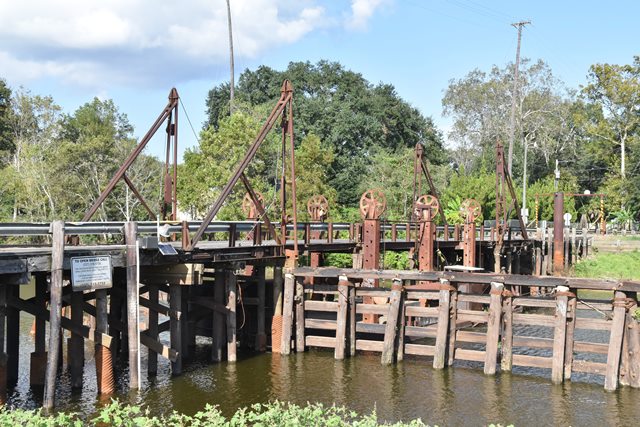
Bridge Status: Demolished and replaced in 2023!This unique bridge is the most unusual of the surviving pontoon swing bridges, a bridge type that is almost unheard of in modern times outside of Louisiana. With a pontoon swing bridge, the movable part of the bridge is a floating barge, that is physically floated away from the roadway to allow boats to pass. This pontoon bridge feautres bascule ramps that connect the fixed approach spans to the pontoon barge, and their movement not only frees the pontoon to be operated for boats, but the adjustable ramps also allow for small changes in water level. Perhaps the most unique feature of this bridge is the large tubular counterweights that parallel the roadway and are connected to sheaves. These are part of a system that allows the roadway to be adjusted and maintained at the correct elevation at significantly different water levels. These counterweights assist with an adjustment system consisting of a steel tower with support pins at 12 inch increments. The pins can be moved to different slots to adjust the roadway level. When HistoricBridges.org visited the bridge, water levels were fairly low, and the counterweights were positioned below the roadway. C. Hanchey provided additional photos in the photo gallery showing a higher water level in which the counterweights are located above the roadway level. Lastly, this video shows the bridge when water levels are very high.
Note: The main span of this bridge is a 40 foot section of roadway supported by a 52 foot long steel pontoon. HAER Documentation states the following: The bridge was moved and erected on current location ca. 1954. It was originally constructed in the 1930s in Vermillion Parish, where it reportedly crossed an oilfield canal. However it is unclear what parts of the bridge date to the 1930s and were in fact moved. The included HAER drawings show a 1951 standard plan for the pontoon.
View Archived National Bridge Inventory Report - Has Additional Details and Evaluation
View Historic American Engineering Record (HAER) Documentation For This Bridge
HAER Drawings, PDF - HAER Data Pages, PDF
Above: Photo from HAER Documentation showing bridge opened.
![]()
Photo Galleries and Videos: Butte Larose Bridge
Bridge Photo-Documentation
Original / Full Size PhotosA collection of overview and detail photos. This gallery offers photos in the highest available resolution and file size in a touch-friendly popup viewer.
Alternatively, Browse Without Using Viewer
![]()
Bridge Photo-Documentation
Mobile Optimized PhotosA collection of overview and detail photos. This gallery features data-friendly, fast-loading photos in a touch-friendly popup viewer.
Alternatively, Browse Without Using Viewer
![]()
Cars Crossing Bridge
Full Motion VideoNote: The downloadable high quality version of this video (available on the video page) is well worth the download since it offers excellent 1080 HD detail and is vastly more impressive than the compressed streaming video. Streaming video of the bridge. Also includes a higher quality downloadable video for greater clarity or offline viewing.
![]()
View Under Bridge With Cars Crossing
Full Motion VideoNote: The downloadable high quality version of this video (available on the video page) is well worth the download since it offers excellent 1080 HD detail and is vastly more impressive than the compressed streaming video. Streaming video of the bridge. Also includes a higher quality downloadable video for greater clarity or offline viewing.
![]()
Maps and Links: Butte Larose Bridge
This historic bridge has been demolished. This map is shown for reference purposes only.
Coordinates (Latitude, Longitude):
Search For Additional Bridge Listings:
Bridgehunter.com: View listed bridges within 0.5 miles (0.8 kilometers) of this bridge.
Bridgehunter.com: View listed bridges within 10 miles (16 kilometers) of this bridge.
Additional Maps:
Google Streetview (If Available)
GeoHack (Additional Links and Coordinates)
Apple Maps (Via DuckDuckGo Search)
Apple Maps (Apple devices only)
Android: Open Location In Your Map or GPS App
Flickr Gallery (Find Nearby Photos)
Wikimedia Commons (Find Nearby Photos)
Directions Via Sygic For Android
Directions Via Sygic For iOS and Android Dolphin Browser
USGS National Map (United States Only)
Historical USGS Topo Maps (United States Only)
Historic Aerials (United States Only)
CalTopo Maps (United States Only)


