We Recommend:
Bach Steel - Experts at historic truss bridge restoration.
BridgeHunter.com Phase 1 is released to the public! - Visit Now
Black Bridge

Primary Photographer(s): Nathan Holth
Bridge Documented: August 19, 2011 and June 15, 2012
Railroad (Maine Central) and Bridge Street Over Androscoggin River
Brunswick and Topsham: Cumberland County, Maine: United States
Metal 12 Panel Rivet-Connected Modified Warren (Subdivided) Through Truss, Fixed and Approach Spans: Metal Through Girder, Fixed
1909 By Builder/Contractor: Pennsylvania Steel Company of Steelton, Pennsylvania
1957
Not Available
318.0 Feet (96.9 Meters)
12.5 Feet (3.81 Meters)
2 Main Span(s) and 2 Approach Span(s)
Not Applicable

View Information About HSR Ratings
Bridge Documentation
This bridge has been altered, resulting in a severe loss of historic integrity and significance!
Bridge Status: This historic bridge's unique suspended deck was demolished by MaineDOT!View Archived National Bridge Inventory Report - Has Additional Details and Evaluation
View Historic American Engineering Record (HAER) Documentation For This Bridge
HAER Data Pages, PDF
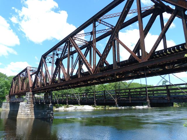
This double deck bridge is one of the most unusual and unique bridges in Maine due to its suspended highway deck which runs under the truss of this bridge. The truss also has a deck in the "normal" place for railroad traffic. Structurally, the bridge is essentially a rivet-connected railroad through truss bridge with no unusual details aside from its use of a Warren truss that is subdivided in a manner similar to a Baltimore truss. However, there is one detail on the truss superstructure that is unique which is the bottom chord connections also have pins in them. These pins hold eyebars which in turn connect to pins at the floorbeams under the bridge which hold the unique suspended highway deck. The lightweight pin-connected nature of the suspended highway deck is a stark contrast to the riveted connections of the truss superstructure. Double-deck bridges are rare, but what is particularly noteworthy is this use of a pin-connected system for the suspended lower deck, as well as the fact that the lower deck is completely suspended below the truss. More commonly, a double-deck truss bridge either has both decks stacked within the truss superstructure, or it has one deck on top of the truss (like a deck truss) while the lower deck runs along the bottom chord level like a through truss.
This bridge was closed to the one-lane traffic it served in 2011 following a vehicle collision with some of the suspenders and subsequent discovery of deterioration in the floor beams and deck surface. MaineDOT apparantly has little interest in preserving this historic bridge since, without hiring any engineers with experience rehabilitating historic bridges to do a detailed study of alternatives, they put out a press release essentially condemning the suspended deck of the bridge to demolition. The exact quote from MaineDOT was "In order to reopen the bridge to vehicle traffic, the entire vehicle portion of the bridge would need to be replaced." This was following an in-depth inspection. In-depth inspections identify problems, but do not necessarily confirm solutions. For such a unique structure, consultation and study with a firm active in preservation of historic bridges is needed. The truth is likely that the suspended structure does not need to be replaced but could instead be repaired, which would retain the unique deck design, as well as the original, unaltered and historically significant materials such as the eyebar hangers.
Information and Findings From Maine's Historic Bridge InventoryDiscussion of Bridge The Free/Black bridge, a 318' long bridge with two, riveted, Baltimore thru truss spans and a 26' long built up stringer approach span (#0999) at the north end. It was built in 1909 to replace a double-decker bridge. This bridge has a deck suspended from the lower chords to carry one lane of vehicular traffic. The upper level carries one track of a minor branch line of the Maine Central RR that was built between Brunswick and Leeds in 1861. The bridge was determined eligible for the National Register by the MHPC in 2000. It is one of four Baltimore truss bridges built between 1890 and 1928. Other double-deck bridges is the state include the Carlton Bridge, a vertical lift bridge at Bath and the Sarah Mildred Long bridge at Kittery, also a vertical lift. There the railroad is on the lower level. The detail of the suspended roadway from the lower chords of the truss is unique, but it appears to be more expedient than technologically innovative. There is also a thru girder span at the south end of the upper level truss bridge, that was placed in 1957, that carries the railroad over US Route 1 (Mill Street) (#0333). Bridge Considered Historic By Survey: Yes |
![]()
Photo Galleries and Videos: Black Bridge
Bridge Photo-Documentation
Original / Full Size PhotosA collection of overview and detail photos. This gallery offers photos in the highest available resolution and file size in a touch-friendly popup viewer.
Alternatively, Browse Without Using Viewer
![]()
Bridge Photo-Documentation
Mobile Optimized PhotosA collection of overview and detail photos. This gallery features data-friendly, fast-loading photos in a touch-friendly popup viewer.
Alternatively, Browse Without Using Viewer
![]()
Maps and Links: Black Bridge
Coordinates (Latitude, Longitude):
Search For Additional Bridge Listings:
Bridgehunter.com: View listed bridges within 0.5 miles (0.8 kilometers) of this bridge.
Bridgehunter.com: View listed bridges within 10 miles (16 kilometers) of this bridge.
Additional Maps:
Google Streetview (If Available)
GeoHack (Additional Links and Coordinates)
Apple Maps (Via DuckDuckGo Search)
Apple Maps (Apple devices only)
Android: Open Location In Your Map or GPS App
Flickr Gallery (Find Nearby Photos)
Wikimedia Commons (Find Nearby Photos)
Directions Via Sygic For Android
Directions Via Sygic For iOS and Android Dolphin Browser
USGS National Map (United States Only)
Historical USGS Topo Maps (United States Only)
Historic Aerials (United States Only)
CalTopo Maps (United States Only)

