We Recommend:
Bach Steel - Experts at historic truss bridge restoration.
BridgeHunter.com Phase 1 is released to the public! - Visit Now
Hillside Avenue Bridge

Primary Photographer(s): Nathan Holth
Bridge Documented: June 16. 2012
Rural: Cumberland County, Maine: United States
Not Available or Not Applicable
50.0 Feet (15.2 Meters)
109.0 Feet (33.2 Meters)
20 Feet (6.1 Meters)
2 Main Span(s)
187

View Information About HSR Ratings
Bridge Documentation
View Archived National Bridge Inventory Report - Has Additional Details and Evaluation
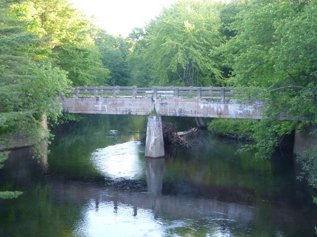
This bridge is a good representative example of a concrete t-beam bridge in Maine. It is a good example due to its lack of alteration, allowing visitors to see what t-beam bridges looked like when originally built. The bridge has deteriorated somewhat, but continues to convey its original appearance and design. The bridge has been closed to traffic. It has likely not been replaced since this road is old US-302 alignment, and is bypassed by the current US-302 which now serves the purpose that this road once did.
Information and Findings From Maine's Historic Bridge InventoryDiscussion of Bridge The 2 span, 109'-long, reinforced concrete T beam bridge built in 1922 has 2 rail high concrete railings, incised paneled fasciae beams, and concrete pier and abutments with wingwalls. The T beam bridge technology has a history common with other standardized reinforced concrete bridge types and by 1910 it was a well established bridge type for spans between 20' and 80' in length because of its efficient use of material and ease of maintenance. T beams were used with great frequency by the MSHC Bridge Division from the late 1910s through the 1950s. T beam bridges are composed of cast-in-place reinforced concrete, longitudinal beams with monolithic flanking deck sections. The bridge is one of more than 250 T beam bridges from 1914 to 1955 in the state. Earlier, complete prototypical examples have been identified. The bridge is not historically or technologically distinguished by its setting or context. Discussion of Surrounding Area The bridge carries a 2 lane road over a stream in a sparsely developed, forested setting. Bridge Considered Historic By Survey: No |
![]()
Photo Galleries and Videos: Hillside Avenue Bridge
Bridge Photo-Documentation
Original / Full Size PhotosA collection of overview and detail photos. This gallery offers photos in the highest available resolution and file size in a touch-friendly popup viewer.
Alternatively, Browse Without Using Viewer
![]()
Bridge Photo-Documentation
Mobile Optimized PhotosA collection of overview and detail photos. This gallery features data-friendly, fast-loading photos in a touch-friendly popup viewer.
Alternatively, Browse Without Using Viewer
![]()
Maps and Links: Hillside Avenue Bridge
Coordinates (Latitude, Longitude):
Search For Additional Bridge Listings:
Bridgehunter.com: View listed bridges within 0.5 miles (0.8 kilometers) of this bridge.
Bridgehunter.com: View listed bridges within 10 miles (16 kilometers) of this bridge.
Additional Maps:
Google Streetview (If Available)
GeoHack (Additional Links and Coordinates)
Apple Maps (Via DuckDuckGo Search)
Apple Maps (Apple devices only)
Android: Open Location In Your Map or GPS App
Flickr Gallery (Find Nearby Photos)
Wikimedia Commons (Find Nearby Photos)
Directions Via Sygic For Android
Directions Via Sygic For iOS and Android Dolphin Browser
USGS National Map (United States Only)
Historical USGS Topo Maps (United States Only)
Historic Aerials (United States Only)
CalTopo Maps (United States Only)

