We Recommend:
Bach Steel - Experts at historic truss bridge restoration.
BridgeHunter.com Phase 1 is released to the public! - Visit Now
Bollman Truss Railroad Bridge

Primary Photographer(s): Dave Michaels
Bridge Documented: April 14, 2007
Railroad (Abandoned Baltimore and Ohio, Rail-Trail) Over Little Patuxent River
Savage: Howard County, Maryland: United States
1869 By Builder/Contractor: Baltimore and Ohio Railroad Mount Clare Shops of Baltimore, Maryland and Engineer/Design: Wendel Bollman of Baltimore, Maryland
2000
79.5 Feet (24.2 Meters)
159.0 Feet (48.5 Meters)
25.5 Feet (7.77 Meters)
2 Main Span(s)
Not Applicable

View Information About HSR Ratings
Bridge Documentation
View Historic American Engineering Record (HAER) Documentation For This Bridge
HAER Drawings, PDF - HAER Data Pages, PDF
View National Historic Landmark Nomination For This Bridge
View The Original Patent For The Bollman Truss Used On This Historic Bridge
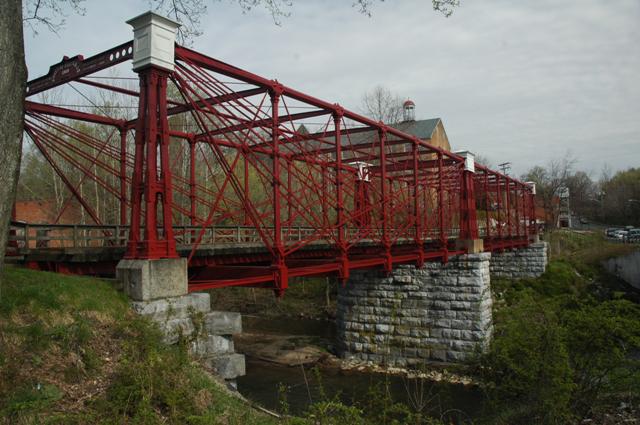
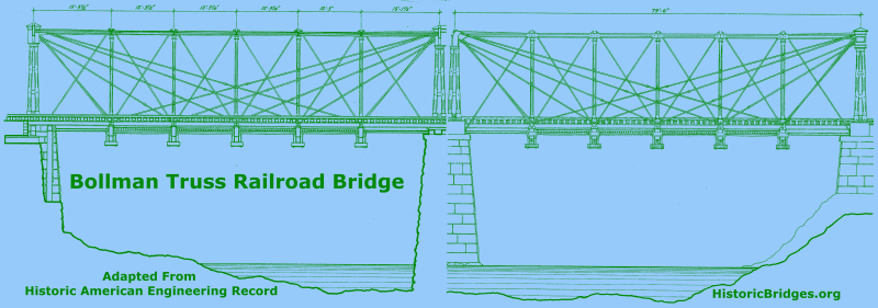
This bridge, which has been restored, is one of the most important historic bridges in the country. This bridge was originally on a B&O mainline, but was moved way back in 1887 to an industrial spur off of the mainline, which allowed this bridge to remain rather than be demolished and replaced with the more familiar massive-member railroad truss bridges. The bridge was built 1869, placing it among the oldest metal bridges in the country. Wendel Bollman, a noted bridge engineer, was responsible for designing this bridge. His unusual truss configuration, known as the Bollman truss, is a very distinctive design that features diagonals that span varying lengths from top to bottom chord. Most diagonals originate from the endpost. As such, one might imagine how the diagonals function in a manner similar to a cable-stayed bridge. In the truss, all compression members on the bridge (top chord, end post, and verticals) are made of cast iron. All tension members (diagonals, bottom chord) are made of wrought iron. The connection of the diagonals to the top of the end post is enclosed in a protective wooden enclosure. Bollman's design was the first metal truss bridge design to be used in any notable quantity by the railroads, and is thus significant in the development of the metal truss bridge. However, today, this bridge is the last remaining example of the Bollman truss, and thus has unparalleled historic value. The bridge was rehabilitated in 1983 and 2000.
Be sure to read the National Historic Landmark nomination for this bridge which includes the most extensive and complete history and description of the bridge available. It is much more extensive than even the HAER narrative.
This bridge is tagged with the following special condition(s): Reused
![]()
Photo Galleries and Videos: Bollman Truss Railroad Bridge
Bridge Photo-Documentation
A collection of overview and detail photos. This photo gallery contains a combination of Original Size photos and Mobile Optimized photos in a touch-friendly popup viewer.Alternatively, Browse Without Using Viewer
![]()
Maps and Links: Bollman Truss Railroad Bridge
Coordinates (Latitude, Longitude):
Search For Additional Bridge Listings:
Bridgehunter.com: View listed bridges within 0.5 miles (0.8 kilometers) of this bridge.
Bridgehunter.com: View listed bridges within 10 miles (16 kilometers) of this bridge.
Additional Maps:
Google Streetview (If Available)
GeoHack (Additional Links and Coordinates)
Apple Maps (Via DuckDuckGo Search)
Apple Maps (Apple devices only)
Android: Open Location In Your Map or GPS App
Flickr Gallery (Find Nearby Photos)
Wikimedia Commons (Find Nearby Photos)
Directions Via Sygic For Android
Directions Via Sygic For iOS and Android Dolphin Browser
USGS National Map (United States Only)
Historical USGS Topo Maps (United States Only)
Historic Aerials (United States Only)
CalTopo Maps (United States Only)


