We Recommend:
Bach Steel - Experts at historic truss bridge restoration.
BridgeHunter.com Phase 1 is released to the public! - Visit Now
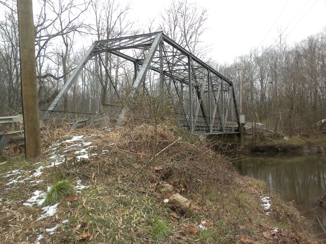
Governor's Bridge

Primary Photographer(s): Bob Dover
Bridge Documented: December 14, 2013
Bowie: Prince Georges County, Maryland and Anne Arundel County, Maryland: United States
Not Available or Not Applicable
114.0 Feet (34.7 Meters)
117.5 Feet (35.8 Meters)
12 Feet (3.66 Meters)
1 Main Span(s)
200000P0599010

View Information About HSR Ratings
Bridge Documentation
View Archived National Bridge Inventory Report - Has Additional Details and Evaluation
View Historic American Engineering Record (HAER) Documentation For This Bridge
HAER Data Pages, PDF
View The Historic Bridge Inventory Report For This Bridge
Information About Bridge Contributed By Bob Dover
Location:
Bowie, on the border between Prince Georges and Anne Arundel
Counties, Maryland. Less than a mile south of US Route 50, about halfway between
Washington DC and Annapolis, Maryland.
Setting:
Completely in woods,
but very close to major suburban development in Bowie, including the Bowie
Baysox minor league baseball stadium, on the west side of the bridge.
Access:
Within about a mile of the intersection of US Route 50 and US Route
301. Take Governor's Bridge Road just southeast of the intersection, behind the
baseball stadium. No designated parking available. At time of site visit,
Governor's Bridge Road was closed, blocked by Jersey barriers, for about a
half-mile on either side of the bridge. You can pull off the shoulder of the
road at the Jersey barriers, and walk down the road to the bridge. The ends of
the bridge itself are also blocked off by Jersey barriers, but there are no
signs, barriers, or gates prohibiting hikers from walking around the barrier and
out onto the bridge.
There are no signs at the bridge explaining the
reason for the road closure. An internet search shows that an inspection in
April, 2013, determined that the bridge was unsafe, and it was closed for
repairs. Those articles, posted in April through July, 2013, report that the
repairs are expected to take up to four weeks. However, the site visit at this
bridge was conducted in December, and there is no sign of any pending
construction activity.
Crosses:
Patuxent River
Current Status:
One-lane bridge, steel grid deck, carries traffic on Governor's Bridge Road, a
narrow, winding two-lane road.
Decorations/Plaques:
No decorations or
date plaques on bridge.
Threats:
The apparent delay in repairs, based
on closure of the bridge in April for an estimated "four weeks" and repairs
having not yet begun in December, may suggest that the county is considering
options that could include removal of the bridge. A local person hiking on the
road to the bridge during the site visit reported that he used the bridge for
commuting, and that closure of the bridge was aggravating. The bridge is less
than a mile south of US Route 50, a major commuting route between Annapolis and
Washington DC, and which has terrible traffic jams in the morning. Locals who
commute between the two counties, but wish to avoid the traffic jams on Route
50, would likely prefer to drive the extra distance on scenic Governor's Bridge
Road for their commute. Therefore, this one-lane bridge likely gets a high
volume of traffic, especially during rush hour, and was probably not sufficient
to handle that traffic . This may account for the delay, if the county is
considering overall sufficiency of the bridge for the traffic volume, instead of
just structural integrity.
HistoricBridges.org Discussion
This is a traditionally composed example of a riveted through truss, a type that is locally uncommon.
![]()
Photo Galleries and Videos: Governor's Bridge
Bridge Photo-Documentation
Original / Full Size PhotosA collection of overview and detail photos. This gallery offers photos in the highest available resolution and file size in a touch-friendly popup viewer.
Alternatively, Browse Without Using Viewer
![]()
Bridge Photo-Documentation
Mobile Optimized PhotosA collection of overview and detail photos. This gallery features data-friendly, fast-loading photos in a touch-friendly popup viewer.
Alternatively, Browse Without Using Viewer
![]()
Maps and Links: Governor's Bridge
Coordinates (Latitude, Longitude):
Search For Additional Bridge Listings:
Bridgehunter.com: View listed bridges within 0.5 miles (0.8 kilometers) of this bridge.
Bridgehunter.com: View listed bridges within 10 miles (16 kilometers) of this bridge.
Additional Maps:
Google Streetview (If Available)
GeoHack (Additional Links and Coordinates)
Apple Maps (Via DuckDuckGo Search)
Apple Maps (Apple devices only)
Android: Open Location In Your Map or GPS App
Flickr Gallery (Find Nearby Photos)
Wikimedia Commons (Find Nearby Photos)
Directions Via Sygic For Android
Directions Via Sygic For iOS and Android Dolphin Browser
USGS National Map (United States Only)
Historical USGS Topo Maps (United States Only)
Historic Aerials (United States Only)
CalTopo Maps (United States Only)

