

View Information About HSR Ratings
Location:
Columbia, Howard County, Maryland. On Guilford Road, less than a
mile from Interstate 95 and Maryland Route 32.
Date:
1902
Setting:
Suburban, in a small park across the road from an office park.
Access:
Exit Maryland Route 32 off of Interstate 95. The bridge sits in a
small park with designated parking, and is also on bike/hike trails.
Crosses:
Little Patuxent River
Current Status:
Closed to traffic,
the bridge was converted in 2002 to bike and pedestrian use only as the Patuxent
Branch Rail Trail. Five historical exhibit plaques at the ends of the bridge
describe the bridge itself, as well as the historical quarry and railroad
operations.
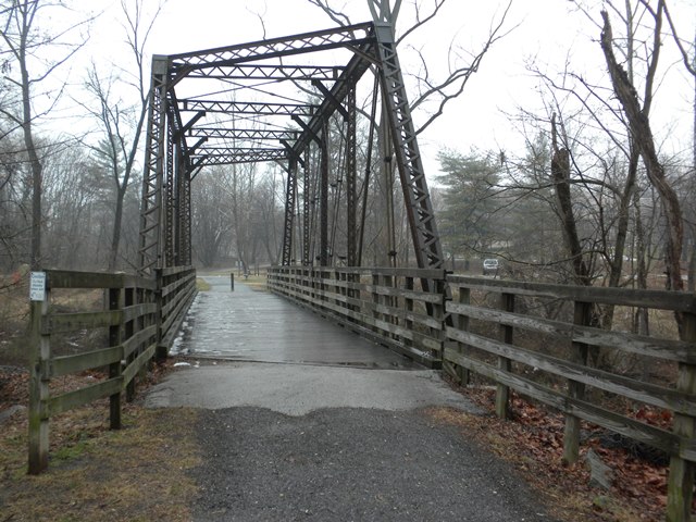
Construction/Description:
Single span Pratt through-truss,
originally constructed as a railroad bridge for the Patuxent Branch of the B&O
Railroad. The vertical components of the truss are compound girders, and the
diagonal supports are a combination of simple light-gauge steel bars and rods,
but separated by wood spacers. The truss is skewed 35 degrees, so the bridge
does not cross the river at a right angle. The two edges of the truss are
offset, so the cross-pieces at the ends of the truss are not perpendicular to
the edges, but connect to the edges at an angle. Color is gray.
Decorations/Plaques:
No decorations or date plaques on bridge. There are five
historical exhibit plaques in the park at the ends of the bridge - three on the
western end and two on the eastern end.
Threats:
Threats are unlikely.
The bridge was rehabilitated in 2002, and is now serving as part of a rail trail
within a county park.
For a railroad bridge, particularly one built in 1902, this bridge has very lightweight members. The laced end posts contribute to this appearance, and also add a nice aesthetic.
![]()
![]()
![]()
Coordinates (Latitude, Longitude):
Search For Additional Bridge Listings:
Bridgehunter.com: View listed bridges within 0.5 miles (0.8 kilometers) of this bridge.
Bridgehunter.com: View listed bridges within 10 miles (16 kilometers) of this bridge.
Additional Maps:
Google Streetview (If Available)
GeoHack (Additional Links and Coordinates)
Apple Maps (Via DuckDuckGo Search)
Apple Maps (Apple devices only)
Android: Open Location In Your Map or GPS App
Flickr Gallery (Find Nearby Photos)
Wikimedia Commons (Find Nearby Photos)
Directions Via Sygic For Android
Directions Via Sygic For iOS and Android Dolphin Browser
USGS National Map (United States Only)
Historical USGS Topo Maps (United States Only)
Historic Aerials (United States Only)
CalTopo Maps (United States Only)

© Copyright 2003-2026, HistoricBridges.org. All Rights Reserved. Disclaimer: HistoricBridges.org is a volunteer group of private citizens. HistoricBridges.org is NOT a government agency, does not represent or work with any governmental agencies, nor is it in any way associated with any government agency or any non-profit organization. While we strive for accuracy in our factual content, HistoricBridges.org offers no guarantee of accuracy. Information is provided "as is" without warranty of any kind, either expressed or implied. Information could include technical inaccuracies or errors of omission. Opinions and commentary are the opinions of the respective HistoricBridges.org member who made them and do not necessarily represent the views of anyone else, including any outside photographers whose images may appear on the page in which the commentary appears. HistoricBridges.org does not bear any responsibility for any consequences resulting from the use of this or any other HistoricBridges.org information. Owners and users of bridges have the responsibility of correctly following all applicable laws, rules, and regulations, regardless of any HistoricBridges.org information.
![]()