


View Information About HSR Ratings
Location:
Near Fallston, on the border between Baltimore County and
Harford County, Maryland. A few miles north of Interstate 95, about 15 miles
northeast of Baltimore.
Date:
1884
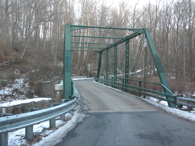
Setting:
Rural, in woods
inside Gunpowder Falls State Park.
Access:
Joppatowne/Mountain Road
exit from I-95. No parking available, and there is no opportunity to pull over
on a shoulder near the bridge. The road is very narrow, and has some traffic, so
walking about a half mile from the nearest pull off to get to the bridge would
be dangerous.
Crosses:
Little Gunpowder Falls
Current Status:
One-lane bridge, wood deck, carries traffic on Vinegar Hill Road, a narrow,
winding two-lane road through the State Park.
Decorations/Plaques:
No
date plaque on bridge. There is some subtle decoration in the upper corners of
the truss, with a trefoil pattern centered inside a circle on the outside, and
then additional circles of decreasing size across the panel towards the center
of the roadway.
Threats:
None known. The bridge is located within a
State Park, and substantial development which would increase traffic needs
beyond the bridge's capability is unlikely.
The Maryland Historic Bridge Inventory indicates that this bridge was built 1884 (not 1894 as shown in the National Bridge Inventory) and by the Penn Bridge Company and cites Proceedings of County Commissioners as the source. So it seems to be documented. But this is unlike anything built by Penn Bridge. Did Penn Bridge perhaps erect a bridge fabricated by others? The unusual ornamental portal bracing knees and equally unusual pipe struts are similar to the Carroll Road Bridge and so one wonders if the same Gilbert who built that bridge (and later reorganized as Gilbert and Smith of Gettysburg, Pennsylvania) was somehow in involved with this one as well.
This bridge is tagged with the following special condition(s): Unorganized Photos
![]()
![]()
![]()
![]()
![]()
Coordinates (Latitude, Longitude):
Search For Additional Bridge Listings:
Bridgehunter.com: View listed bridges within 0.5 miles (0.8 kilometers) of this bridge.
Bridgehunter.com: View listed bridges within 10 miles (16 kilometers) of this bridge.
Additional Maps:
Google Streetview (If Available)
GeoHack (Additional Links and Coordinates)
Apple Maps (Via DuckDuckGo Search)
Apple Maps (Apple devices only)
Android: Open Location In Your Map or GPS App
Flickr Gallery (Find Nearby Photos)
Wikimedia Commons (Find Nearby Photos)
Directions Via Sygic For Android
Directions Via Sygic For iOS and Android Dolphin Browser
USGS National Map (United States Only)
Historical USGS Topo Maps (United States Only)
Historic Aerials (United States Only)
CalTopo Maps (United States Only)

© Copyright 2003-2026, HistoricBridges.org. All Rights Reserved. Disclaimer: HistoricBridges.org is a volunteer group of private citizens. HistoricBridges.org is NOT a government agency, does not represent or work with any governmental agencies, nor is it in any way associated with any government agency or any non-profit organization. While we strive for accuracy in our factual content, HistoricBridges.org offers no guarantee of accuracy. Information is provided "as is" without warranty of any kind, either expressed or implied. Information could include technical inaccuracies or errors of omission. Opinions and commentary are the opinions of the respective HistoricBridges.org member who made them and do not necessarily represent the views of anyone else, including any outside photographers whose images may appear on the page in which the commentary appears. HistoricBridges.org does not bear any responsibility for any consequences resulting from the use of this or any other HistoricBridges.org information. Owners and users of bridges have the responsibility of correctly following all applicable laws, rules, and regulations, regardless of any HistoricBridges.org information.
![]()