

View Information About HSR Ratings
It is assumed that Patapsco Bridge and Iron Works of Baltimore, Maryland built this bridge, as that was the company that famous engineer Wendel Bollman of Baltimore, Maryland was running at the time this bridge was built.

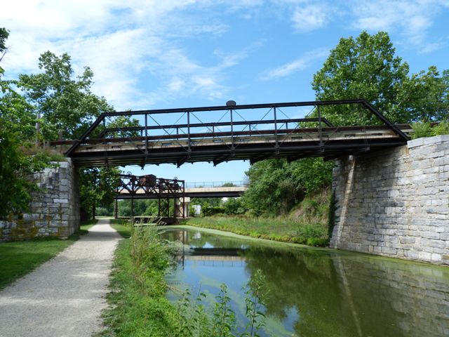
This bridge was designed and built by Wendel Bollman, inventor of the Bollman truss configuration. This is not a Bollman truss however. Instead, it is a very old example of a pin-connected Pratt truss. As a pony truss, it has very small panels, giving this 67 foot span eight panels, a very large number of panels for a bridge of this size. The bridge no longer bears the weight of traffic, since steel stringers have been added between the deck and the floor beams to support traffic. The truss only supports its own weight. While preservationists with engineering interests likely would condemn this preservation project because the truss no longer bears any live load, preservationists who value integrity of original design and materials will find this to be a good compromise preservation solution. Because the stringers support the load, alteration or retrofit of the truss was not needed. The manner in which the stringers was added is sensitive. They are located above the floor beams, so they are not readily visible, and they have the appearance of oversized deck stringers, so they do not stick out even when seen. Also important is that the floorbeams or trusses were not altered. The stringers slip right in above the floorbeams without disturbing the truss.
![]()
![]()
![]()

![]()
Coordinates (Latitude, Longitude):
Search For Additional Bridge Listings:
Bridgehunter.com: View listed bridges within 0.5 miles (0.8 kilometers) of this bridge.
Bridgehunter.com: View listed bridges within 10 miles (16 kilometers) of this bridge.
Additional Maps:
Google Streetview (If Available)
GeoHack (Additional Links and Coordinates)
Apple Maps (Via DuckDuckGo Search)
Apple Maps (Apple devices only)
Android: Open Location In Your Map or GPS App
Flickr Gallery (Find Nearby Photos)
Wikimedia Commons (Find Nearby Photos)
Directions Via Sygic For Android
Directions Via Sygic For iOS and Android Dolphin Browser
USGS National Map (United States Only)
Historical USGS Topo Maps (United States Only)
Historic Aerials (United States Only)
CalTopo Maps (United States Only)

© Copyright 2003-2026, HistoricBridges.org. All Rights Reserved. Disclaimer: HistoricBridges.org is a volunteer group of private citizens. HistoricBridges.org is NOT a government agency, does not represent or work with any governmental agencies, nor is it in any way associated with any government agency or any non-profit organization. While we strive for accuracy in our factual content, HistoricBridges.org offers no guarantee of accuracy. Information is provided "as is" without warranty of any kind, either expressed or implied. Information could include technical inaccuracies or errors of omission. Opinions and commentary are the opinions of the respective HistoricBridges.org member who made them and do not necessarily represent the views of anyone else, including any outside photographers whose images may appear on the page in which the commentary appears. HistoricBridges.org does not bear any responsibility for any consequences resulting from the use of this or any other HistoricBridges.org information. Owners and users of bridges have the responsibility of correctly following all applicable laws, rules, and regulations, regardless of any HistoricBridges.org information.
![]()