We Recommend:
Bach Steel - Experts at historic truss bridge restoration.
BridgeHunter.com Phase 1 is released to the public! - Visit Now
11th Street Bridge

Primary Photographer(s): Nathan Holth and Rick McOmber
Bridge Documented: July 13, 2008
Turners Falls: Franklin County, Massachusetts: United States
1915 By Builder/Contractor: Eastern Bridge and Structural Company of Worcester, Massachusetts
1996
167.0 Feet (50.9 Meters)
205.0 Feet (62.5 Meters)
24 Feet (7.32 Meters)
1 Main Span(s)
M28017

View Information About HSR Ratings
Bridge Documentation
View Archived National Bridge Inventory Report - Has Additional Details and Evaluation
View Historic American Engineering Record (HAER) Documentation For This Bridge
HAER Data Pages, PDF
View Massachusetts Historical Commission (MHC) Inventory Forms For This Historic Bridge

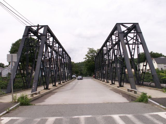
This is one of the most bizarre bridges ever to be encountered. One look at the bridge shows that this is one strange bridge, since it has what looks like two narrow through trusses on either side of the roadway. The bridge has a striking appearance with its tall trusses that make crossing this bridge both exciting and enjoyable. This is a sharp contrast to modern bridges which offer nothing of interest since most are little more than slabs of concrete. This bridge is a great example of why historic bridges are so interesting and important to preserve.
One could have a very good debate on whether this bridge is a through truss or a pony truss. The Historic American Engineering Record (HAER) describes the bridge as a "triple-barreled through truss" which refers to the three portals that this bridge has, one for each of the two sidewalks, and a third for the roadway. From an engineer's standpoint you could consider this two through trusses holding a suspended span for the roadway in the center. Alternatively, if you think of the two trusses as simply two built-up truss lines... two truss lines made wide through an assembly of bracing and member beams... than you could argue that this bridge is a massive pony truss, since there is no bracing above the roadway.
Since HAER has listed this bridge as a through truss, it is being listed as a through truss here on HistoricBridges.org.
Why would such an odd bridge like this be built? Perhaps there was a need or desire to have a large single span bridge rather than place a pier in he canal, yet at the same time a need/desire to avoid having bracing over the roadway. Perhaps large or tall industrial things were being transported to and from the island.
This is a truly unique bridge and as such it has an extremely high level of historic significance. Its maintenance and preservation should receive the highest priority.
![]()
Photo Galleries and Videos: 11th Street Bridge
Bridge Photo-Documentation
Original / Full Size PhotosA collection of overview and detail photos. This gallery offers photos in the highest available resolution and file size in a touch-friendly popup viewer.
Alternatively, Browse Without Using Viewer
![]()
Bridge Photo-Documentation
Mobile Optimized PhotosA collection of overview and detail photos. This gallery features data-friendly, fast-loading photos in a touch-friendly popup viewer.
Alternatively, Browse Without Using Viewer
![]()
Maps and Links: 11th Street Bridge
Coordinates (Latitude, Longitude):
Search For Additional Bridge Listings:
Bridgehunter.com: View listed bridges within 0.5 miles (0.8 kilometers) of this bridge.
Bridgehunter.com: View listed bridges within 10 miles (16 kilometers) of this bridge.
Additional Maps:
Google Streetview (If Available)
GeoHack (Additional Links and Coordinates)
Apple Maps (Via DuckDuckGo Search)
Apple Maps (Apple devices only)
Android: Open Location In Your Map or GPS App
Flickr Gallery (Find Nearby Photos)
Wikimedia Commons (Find Nearby Photos)
Directions Via Sygic For Android
Directions Via Sygic For iOS and Android Dolphin Browser
USGS National Map (United States Only)
Historical USGS Topo Maps (United States Only)
Historic Aerials (United States Only)
CalTopo Maps (United States Only)

