We Recommend:
Bach Steel - Experts at historic truss bridge restoration.
BridgeHunter.com Phase 1 is released to the public! - Visit Now
Aiken Street Bridge
Ouellette Bridge

Primary Photographer(s): Nathan Holth and Rick McOmber
Bridge Documented: July 12, 2008
Lowell: Middlesex County, Massachusetts: United States
1883 By Builder/Contractor: Berlin Iron Bridge Company of East Berlin, Connecticut
1998
155.0 Feet (47.2 Meters)
780.0 Feet (237.7 Meters)
29 Feet (8.84 Meters)
5 Main Span(s)
L15020

View Information About HSR Ratings
Bridge Documentation
View Archived National Bridge Inventory Report - Has Additional Details and Evaluation
HAER Data Pages, PDF
View Massachusetts Historical Commission (MHC) Inventory Forms For This Historic Bridge
View A Berlin Iron Bridge Company Catalog
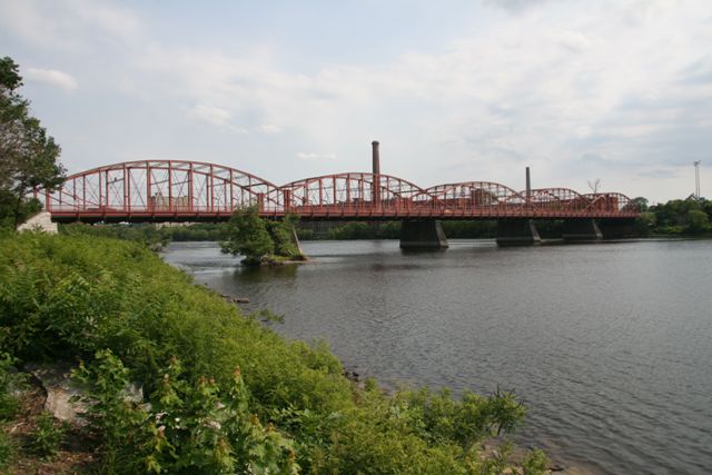
This bridge is among the most beautiful bridges in the country, with its repeating, gracefully flowing lenticular shapes combining with the intricate trusses and built-up beams which contain attractive v-lacing and lattice in many places. It is the longest lenticular truss bridge in the country, and also is in first place for most number of lenticular spans, which is five. This is a nationally significant bridge, but is also significant on a statewide basis as the second oldest lenticular truss bridge in the Massachusetts.
HAER has a significant narrative for this bridge with a lot of information, be sure to check it out.
The bridge has been rehabilitated and today remains in excellent condition with an attractive red paint present on the bridge. The rehabilitations appears to have been sensitive to the historic materials and design of the bridge. Original riveted, built-up floorbeams remain on the bridge. Vehicular railings protect the bridge from impact damage, but are low profile and non-obstructive visually. Original decorative lattice pedestrian railings remain. While some metal has been bolted onto some parts of the bridge, no major members have been replaced or obstructed by large modern additions to the bridge. The work was well done, and as of 2009 the bridge had a high sufficiency rating. In additional testimony to the wide deck width for a bridge from the 1880s, the bridge is not even listed as functionally obsolete in the National Bridge Inventory, which is unusual for a historic bridge. This is a bridge that deserves the highest preservation priority, and it appears that it has indeed received this.
This bridge appears to have been one of the more significant achievements of the Berlin Iron Bridge Company. Thanks to the digitized archives of Cumberland County, Pennsylvania, an original proposal and specifications for a truss bridge is available to provide a look into the Berlin Iron Bridge Company and the typical conduct and business operation of it and other bridge companies of the late 19th Century. The two images seen in this narrative are taken from the proposal. This proposal's beautiful letterhead logo (shown at the top of this narrative), and the Aiken Street Bridge is one of the bridges pictured in the logo. This suggests the pride the company felt upon completing what was undoubtedly among their larger projects. The complete proposal is available in PDF format here. The images were digitized by Cumberland County, Pennsylvania. Although the proposal is for a bridge in Cumberland County, Pennsylvania it is likely representative of the sort of proposal that would have have been supplied by the company for the Aiken Street Bridge and other bridges the company built. During this period in history, the purchaser (city, county, etc) often did not produce a very detailed contract proposal as is done today, and instead the contractor (the bridge company) often took the lead role in not just construction, but engineering as well. This is why the Aiken Street Bridge turned out to be a lenticular truss bridge, simply because Berlin Iron Bridge Company was the company who was hired to build the bridge. If a different company, such as the Wrought Iron Bridge Company had been hired instead, the bridge would undoubtedly been a completely different truss type. Also, the proposal, specifications, and plan sheets provided for these bridges to the purchaser were often nowhere near as detailed as plans and specifications seen for bridges in the 20th Century, where owner agencies began to took the lead role in design.
![]()
Photo Galleries and Videos: Aiken Street Bridge
Bridge Photo-Documentation
Original / Full Size PhotosA collection of overview and detail photos. This gallery offers photos in the highest available resolution and file size in a touch-friendly popup viewer.
Alternatively, Browse Without Using Viewer
![]()
Bridge Photo-Documentation
Mobile Optimized PhotosA collection of overview and detail photos. This gallery features data-friendly, fast-loading photos in a touch-friendly popup viewer.
Alternatively, Browse Without Using Viewer
![]()
Maps and Links: Aiken Street Bridge
Coordinates (Latitude, Longitude):
Search For Additional Bridge Listings:
Bridgehunter.com: View listed bridges within 0.5 miles (0.8 kilometers) of this bridge.
Bridgehunter.com: View listed bridges within 10 miles (16 kilometers) of this bridge.
Additional Maps:
Google Streetview (If Available)
GeoHack (Additional Links and Coordinates)
Apple Maps (Via DuckDuckGo Search)
Apple Maps (Apple devices only)
Android: Open Location In Your Map or GPS App
Flickr Gallery (Find Nearby Photos)
Wikimedia Commons (Find Nearby Photos)
Directions Via Sygic For Android
Directions Via Sygic For iOS and Android Dolphin Browser
USGS National Map (United States Only)
Historical USGS Topo Maps (United States Only)
Historic Aerials (United States Only)
CalTopo Maps (United States Only)


