

View Information About HSR Ratings
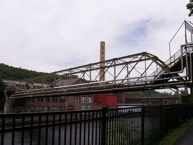
This unique riveted truss bridge provides direct pedestrian access to a historic paper mill. The bridge actually rests on part of the building, and the bridge deposits pedestrians right on the second floor of the mill. The original lattice railing that is on the bridge continues on this "porch" of the building, emphasizing the connection and relationship of bridge to building. This unique connection makes this historic bridge a critical part of the mill building, and the two historic structures should be considered inseparable in any preservation discussion.
Unfortunately, a study done on ways to reuse this closed/nearly abandoned paper mill recommends the demolition of the entire historic bridge and replacement with a glass enclosed bridge that will not match the historic appearance of the mill buildings and will result in the loss of this bridge.
If plans to preserve this mill move forward, HistoricBridges.org instead strongly recommends the preservation of the trusses of this bridge in their current location, either to serve functionally as pedestrian access, or left unused and simply preserved for its historic and aesthetic value. Construction of a second bridge to serve the ADA requirements and other needs should be considered at a different location, such that this new bridge would not require the demolition of the historic bridge.
Information and Findings From Strathmore Mill Potential Reuse StudyOverview Keith Paper Company Pedestrian access to the mill has always utilized a footbridge across the canal. This option for dramatic pedestrian access to the mill remains one of the very positive aspects of this site. The earliest image of the mill dating back to 1873 show a low lying bridge spanning the canal near building #4. At the turn of the century the canal was widened and a new footbridge in its current elevated position was established. Discussion of Bridge The Strathmore Pedestrian Bridge provides access to the Strathmore Mill from the village of Turner Falls over the Turners Falls canal. The bridge is currently owned and maintained by Northeast Generating Services (NGS). The bridge has a span of 153 feet and is constructed of riveted steel trusses, steel angle cross bracing and a 3- inch wood plank walking surface. A 60 foot long steel framed walkway begins at the Canal Street side of the footbridge and connects to a steel and wood framed staircase that leads down to the pedestrian bridge. On the paper mill side of the bridge, a similar steel and wood framed staircase leads from the end of the bridge down to the entrance to the mill on the fourth floor of Building No. 1. The bridge is currently closed which prevented us from making close observations. NGS had the bridge inspected in 2004 and have provided the report to us for our review. The results of their inspection indicate that the lower chord framing has suffered corrosion and will require a combination of repair and replacement. In addition, angle cross bracing and gusset connections that brace the lower chords of the truss are corroded and will have to be replaced. The stairs, located at each end of the bridge are severely corroded and will need to be replaced. The severe corrosion was most likely caused by de-icing salts used on the pedestrian bridge. Cianbro Construction provided NGS a budgetary estimate of $275,000 to repair the bridge in kind. However, the proposed development of the mill complex will require that the pedestrian bridge be enclosed and elevated to the fifth floor of the mill complex. In addition, the bridge will be extended through Building No. 1, where it will provide an outlook to the river. It is Tighe & Bond's opinion that the costs to repair and upgrade the existing pedestrian bridge for the proposed development will most likely approach the cost for a new bridge. Reuse/Demolition Discussion The bridge spans approximately 150 feet from abutment to abutment and 230 feet from Canal Road to the fourth level of Building #4. The current configuration utilizes stairs at either end of the bridge to make up the difference in elevation. The bridge is owned by Northeast Generation Services, which recently conducted a structural review. The stair structures and members supporting the wooden deck are in need of repair after years of de-icing with salt. Renovations to the foot bridge have been estimated at $275,000. Any proposed development of the mill utilizing the bridge must also make the bridge ADA accessible. One way to achieve this is to provide lifts at either end. A better solution is to remove the stairs, raise the bridge on the Canal Street side to meet the road and span across to meet the 5th level of the tower near building #1. The tower junction is envisioned as the heart for circulation throughout the mill. A connection through building #1 to the Connecticut River side might include an observation deck that will help draw pedestrians across the bridge. The proposed bridge is approximately 250 feet long from the river to Canal Street. We also recommended the bridge be enclosed in large part by glass to allow light and visual interest to pedestrians. Further structural investigation is required to determine the capacity of the existing bridge to carry the enclosure. The cost of the proposed covered bridge is $780,000. |
![]()
![]()
![]()
Coordinates (Latitude, Longitude):
Search For Additional Bridge Listings:
Bridgehunter.com: View listed bridges within 0.5 miles (0.8 kilometers) of this bridge.
Bridgehunter.com: View listed bridges within 10 miles (16 kilometers) of this bridge.
Additional Maps:
Google Streetview (If Available)
GeoHack (Additional Links and Coordinates)
Apple Maps (Via DuckDuckGo Search)
Apple Maps (Apple devices only)
Android: Open Location In Your Map or GPS App
Flickr Gallery (Find Nearby Photos)
Wikimedia Commons (Find Nearby Photos)
Directions Via Sygic For Android
Directions Via Sygic For iOS and Android Dolphin Browser
USGS National Map (United States Only)
Historical USGS Topo Maps (United States Only)
Historic Aerials (United States Only)
CalTopo Maps (United States Only)

© Copyright 2003-2025, HistoricBridges.org. All Rights Reserved. Disclaimer: HistoricBridges.org is a volunteer group of private citizens. HistoricBridges.org is NOT a government agency, does not represent or work with any governmental agencies, nor is it in any way associated with any government agency or any non-profit organization. While we strive for accuracy in our factual content, HistoricBridges.org offers no guarantee of accuracy. Information is provided "as is" without warranty of any kind, either expressed or implied. Information could include technical inaccuracies or errors of omission. Opinions and commentary are the opinions of the respective HistoricBridges.org member who made them and do not necessarily represent the views of anyone else, including any outside photographers whose images may appear on the page in which the commentary appears. HistoricBridges.org does not bear any responsibility for any consequences resulting from the use of this or any other HistoricBridges.org information. Owners and users of bridges have the responsibility of correctly following all applicable laws, rules, and regulations, regardless of any HistoricBridges.org information.
![]()