We Recommend:
Bach Steel - Experts at historic truss bridge restoration.
BridgeHunter.com Phase 1 is released to the public! - Visit Now
88th Avenue Bridge

Primary Photographer(s): Rick McOmber
Bridge Documented: May 15, 2010, June 13, 2011, and June 12, 2022
Rural: Oceana County, Michigan: United States
By Builder/Contractor: Groton Bridge Company of Groton, New York
1912
48.0 Feet (14.6 Meters)
49.0 Feet (14.9 Meters)
14 Feet (4.27 Meters)
1 Main Span(s)
64316H00028B020

View Information About HSR Ratings
Bridge Documentation
This bridge's future is at risk!
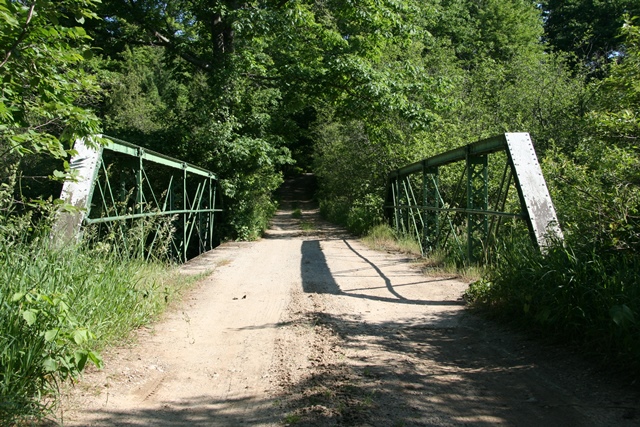
Bridge Status: This bridge has been closed to traffic, and as of 2021 is slated for demolition without replacement at FY 2022, Local Agency Bridge Bundling Program.This bridge is one of the only bridges in the entire county with any heritage value. Indeed, it is one of the few historic bridges of any type in the region. Many counties in northwestern lower Michigan are strikingly devoid of historic bridges. This makes the preservation of each surviving historic bridge essential.
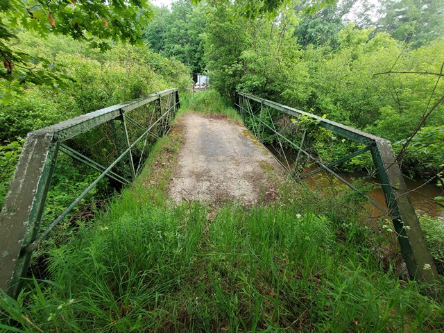
This particular bridge is an excellent historic bridge. Although a small and relatively late example of a once-common structure type, the bridge is noteworthy for what appears to be extremely high level of historic integrity. This bridge retains excellent historic integrity in most areas, including original pole railings, unaltered trusses, and original pole railings, and riveted built-up i-beam style floorbeams.
In particular, the retention of a jack-arch deck is very noteworthy. Even if it is not original to the bridge, it appears to be very old and should therefore be considered historically significant. Jack-arch decks are quite rare in Michigan and are nearly unheard of in many other states. It is unclear why Michigan has a few more examples of jack-arch decks. Some jack-arch decks survive in Michigan because Michigan has left bridges that were abandoned decades ago standing, and these bridges retain the decks that would have been replaced on bridges left open to traffic. In other cases, such as with this bridge, the extremely rural location of the bridge may have meant that the bridge deck never had to be replaced.
The bridge has a 14 foot roadway width which is typical for a bridge of its age. On most roads today, this one-lane width looks very narrow. However on this extremely rural and lightly traveled road, the bridge is actually wider than the road, giving the bridge a fairly wide appearance.
1912 is the construction date given for this bridge. The jack-arch deck on the bridge would be typical of bridges built in this period. However, other features of this bridge appear more like a bridge from the 1890s, including the built-up floorbeams and the cast iron design of the nuts for the connection pins. There is a strong likelihood that in reality this bridge was built in the 1890s by the Groton Bridge Company of Groton, New York (which used the unusual and distinctive cast iron nuts and preferred the latticed verticals seen on this bridge). The bridge may have been moved to this location in 1912 which would explain the date, and would also have likely prompted a new deck to be placed on the bridge, which would explain the jack-arch deck, which would likely not have been built in the 1890s.
Generally in truss bridge preservation work, the deck stringers and surface are not considered part of the historical significance of the bridge and so normally it is not a concern when a deck is replaced, even if the replacement is not in-kind. In the case of truss bridges with jack-arch decks however, the deck design should be considered part of the bridge's significance. When the time comes to rehabilitate and preserve this historic bridge and if it is found that the existing deck is extremely deteriorated and needs to be replaced, HistoricBridges.org recommends replacing the deck with a replica jack-arch design. The key feature is half of a corrugated metal tube (like a culvert) that spans between the top of the bottom flanges on the deck stringers to hold the concrete deck poured above. Thus, replicating a jack-arch would be relatively easy since the construction is simple and uses materials easily available today.

Above: Bridge in 2022. Photo Credit: Jason Holloway.
This bridge is tagged with the following special condition(s): Unorganized Photos
![]()
Photo Galleries and Videos: 88th Avenue Bridge
2010 Bridge Photo-Documentation
Original / Full Size PhotosA collection of overview and detail photos. This gallery offers photos in the highest available resolution and file size in a touch-friendly popup viewer.
Alternatively, Browse Without Using Viewer
![]()
2010 Bridge Photo-Documentation
Mobile Optimized PhotosA collection of overview and detail photos. This gallery features data-friendly, fast-loading photos in a touch-friendly popup viewer.
Alternatively, Browse Without Using Viewer
![]()
Additional Unorganized Photos
Original / Full Size PhotosA supplemental collection of photos that are from additional visit(s) to the bridge and have not been organized or captioned. This gallery offers photos in the highest available resolution and file size in a touch-friendly popup viewer.
Alternatively, Browse Without Using Viewer
![]()
Additional Unorganized Photos
Mobile Optimized PhotosA supplemental collection of photos that are from additional visit(s) to the bridge and have not been organized or captioned. This gallery features data-friendly, fast-loading photos in a touch-friendly popup viewer.
Alternatively, Browse Without Using Viewer
![]()
Maps and Links: 88th Avenue Bridge
Coordinates (Latitude, Longitude):
Search For Additional Bridge Listings:
Bridgehunter.com: View listed bridges within 0.5 miles (0.8 kilometers) of this bridge.
Bridgehunter.com: View listed bridges within 10 miles (16 kilometers) of this bridge.
Additional Maps:
Google Streetview (If Available)
GeoHack (Additional Links and Coordinates)
Apple Maps (Via DuckDuckGo Search)
Apple Maps (Apple devices only)
Android: Open Location In Your Map or GPS App
Flickr Gallery (Find Nearby Photos)
Wikimedia Commons (Find Nearby Photos)
Directions Via Sygic For Android
Directions Via Sygic For iOS and Android Dolphin Browser
USGS National Map (United States Only)
Historical USGS Topo Maps (United States Only)
Historic Aerials (United States Only)
CalTopo Maps (United States Only)

