We Recommend:
Bach Steel - Experts at historic truss bridge restoration.
BridgeHunter.com Phase 1 is released to the public! - Visit Now
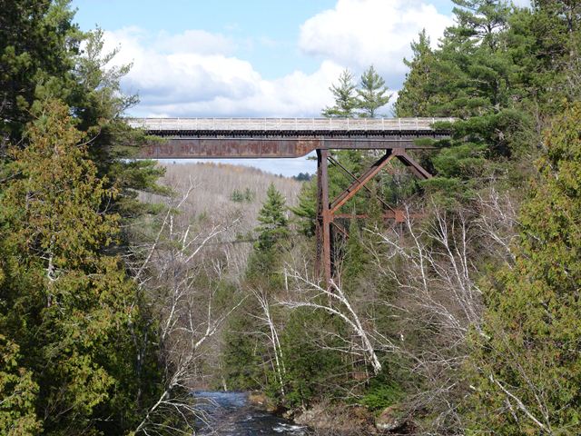
Agate Falls Railroad Bridge

Primary Photographer(s): Nathan Holth
Bridge Documented: October 1, 2012
Railroad (Bergland to Sidnaw Rail Trail / Trail 8) Over Middle Branch Ontonagon River
Rural: Ontonagon County, Michigan: United States
1900 By Builder/Contractor: American Bridge Company of New York, New York
Not Available or Not Applicable
Not Available
Not Available
Not Available
Main Span Count Not Available
Not Applicable

View Information About HSR Ratings
Bridge Documentation
View Archived National Bridge Inventory Report - Has Additional Details and Evaluation
Built in 1900 by the American Bridge Company, this is one of the first bridges ever built by the prolific bridge builder, constructed in the company's first year of operation. The company was formed by buying up a bunch of smaller bridge companies to form one big company. In the first couple years of the company's existence, its operation strongly relied on the existing facilities and practices of the companies it had absorbed. Evidence of that is found in the builder plaque for this bridge that lists not only the American Bridge Company name, but states "Lassig Branch, Chicago, Ill." This refers to what was previously Lassig Bridge and Iron Works of Chicago, Illinois that was bought by the American Bridge Company. Indeed, the plaque on this bridge still has the shape of a Lassig Bridge and Iron Works plaque, rather than the American Bridge Company style plaque the company would later adopt.
The bridge is a high level deck plate girder bridge supported by steel bents, a traditional type of bridge for high level railroad crossings often called "steel trestle" bridges. Given that only certain areas of Michigan display the topography that necessitates this type of bridge, this is a rare bridge variety in Michigan. Most examples of this type are, like this bridge, located in the Upper Penninsula.
This bridge is located in a scenic park setting next to a waterfall. The bridge is today serving a ORV and snowmobile trail.
![]()
Photo Galleries and Videos: Agate Falls Railroad Bridge
Bridge Photo-Documentation
Original / Full Size PhotosA collection of overview and detail photos. This gallery offers photos in the highest available resolution and file size in a touch-friendly popup viewer.
Alternatively, Browse Without Using Viewer
![]()
Bridge Photo-Documentation
Mobile Optimized PhotosA collection of overview and detail photos. This gallery features data-friendly, fast-loading photos in a touch-friendly popup viewer.
Alternatively, Browse Without Using Viewer
![]()
Maps and Links: Agate Falls Railroad Bridge
Coordinates (Latitude, Longitude):
Search For Additional Bridge Listings:
Bridgehunter.com: View listed bridges within 0.5 miles (0.8 kilometers) of this bridge.
Bridgehunter.com: View listed bridges within 10 miles (16 kilometers) of this bridge.
Additional Maps:
Google Streetview (If Available)
GeoHack (Additional Links and Coordinates)
Apple Maps (Via DuckDuckGo Search)
Apple Maps (Apple devices only)
Android: Open Location In Your Map or GPS App
Flickr Gallery (Find Nearby Photos)
Wikimedia Commons (Find Nearby Photos)
Directions Via Sygic For Android
Directions Via Sygic For iOS and Android Dolphin Browser
USGS National Map (United States Only)
Historical USGS Topo Maps (United States Only)
Historic Aerials (United States Only)
CalTopo Maps (United States Only)

